The Winter Solstice is Saturday, but winter will certainly make it’s presence felt over the next few days.
The low pressure system that produced severe weather across the South on Monday will head northeastward, impacting our area on Tuesday. The storm will be moving fairly quickly, and it doesn’t have a lot of cold air to work with, so we’re not expecting a big snowstorm. That doesn’t mean it won’t cause any problems.

Snow will develop around midnight across parts of Connecticut and Southern Rhode Island, gradually spreading northward across the rest of the region before daybreak. The snow should quickly change to rain after daybreak across the South Coast and Cape Cod. As warmer air moves in aloft, a change to sleet and freezing rain will start to take place across the interior, with plain rain along the coast as milder air moves in off the still relatively mild ocean. Right now, it looks like the mixing may get as far north as the Merrimack Valley during the afternoon. North of there, precipitation should stay all snow. The precipitation will lighten up during the afternoon, but won’t completely end until the evening or first part of the overnight.
The morning and evening commute will both be impacted by this storm, but the greater impacts will certainly be during the morning commute. Not only could icing be a problem, especially in parts of Connecticut and Rhode Island, we could be looking at a band of moderate to heavy snow along and south of the Mass Pike. With temperatures expected to drop below freezing at night, many roads could ice back up, so untreated surfaces could become slick, especially in areas that changed over to rain during the afternoon.

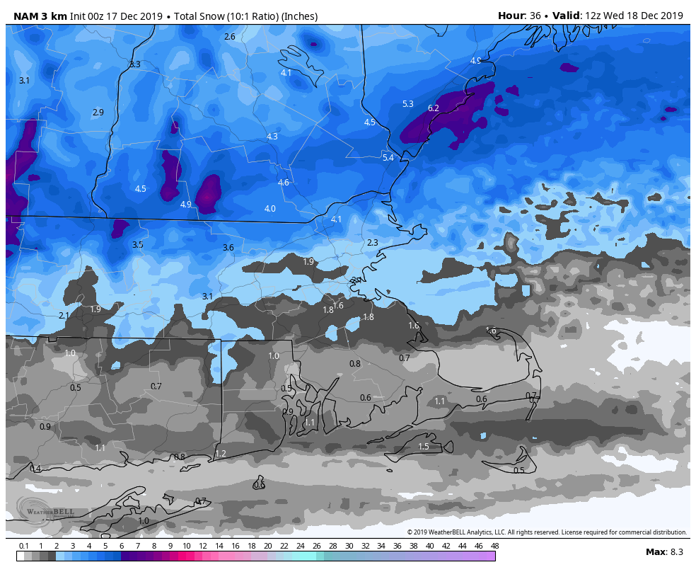
As for how much snow to expect, we haven’t changed our thinking much from our earlier forecast.
South Coast/Cape Cod: Less than 1″
Southeastern Massachusetts (including the I-95 corridor): 1-2″
MetroWest/North Shore: 1-3″
Merrimack Valley: 2-4″
Central + Southern New Hampshire/NH Seacoast: 3-6″
Behind this system, we’ve got to pay attention to an arctic cold front that will move across the region late Wednesday. It could produce some snow showers or squalls as it moves through. These won’t impact everyone, but in places they do, visibility could rapidly drop, and a quick half an inch to an inch of snow could fall.

Behind that front, some of the coldest air so far this season will settle in for Thursday. Wind chills will be below zero during the morning hours, and actual temperatures may not make it out of the teens during the afternoon. Friday will see temperatures start to moderate a bit, but it will still remain quite chilly, even by December standards.
