The first full week of March is shaping up to be a wintry one, mainly in the temperature department, but a little in the precipitation department as well.
The snow will be ending across the region this morning as our storm system pulls away, with some clearing this afternoon. Temperatures may even get a tad mild, allowing for some melting to take place. However, we’re going to drop back below freezing tonight, so anything that melted with ice back up. If you’re heading out this evening, watch out for slippery conditions on untreated surfaces.

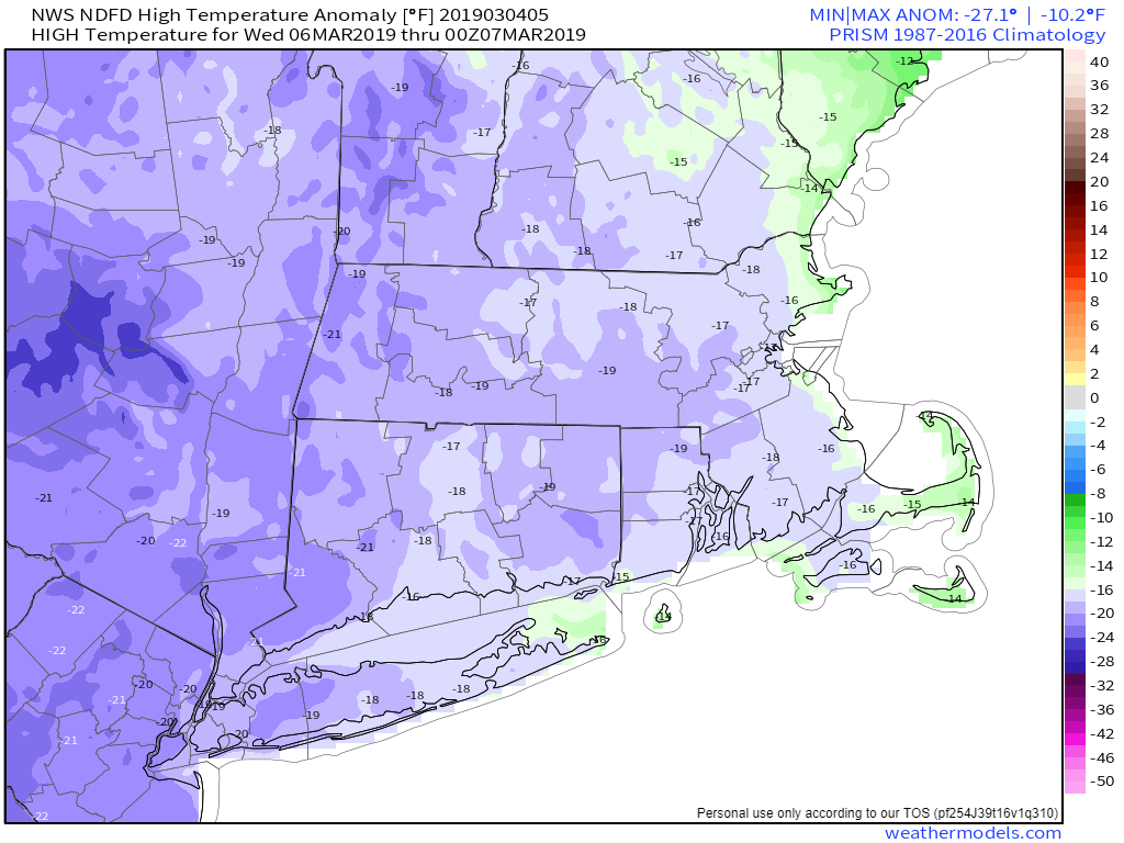
After that, a rather cold airmass will settle into the region for Tuesday through Thursday. While temperatures won’t be as extreme as in the Plains states, we’re still looking at temperatures that are 10-20 degrees below normal, especially Wednesday and Thursday. A couple of upper-level disturbances will also be moving through the region, which may produce a few snow showers at times, especially Wednesday and Thursday.
By Friday, high pressure will move offshore and temperatures will start to moderate. That just means it won’t be quite as cold, but temperatures will still be below normal. The weekend is where things get complicated.
It looks like we’re going to have 2 systems impact the area, a weak one on Saturday, and a stronger one on Saturday. Given that these are both several days away, nothing is set in stone at this point. The first system passes south of New England on Saturday. There is at least one model that has it pass too far south to have any impact on us, but most bring it close enough to spread in some light precipitation. Right now, it looks likely mainly some light snow, but it could be some rain as well, especially along the south coast.
The stronger storm comes in on Sunday. This one looks like it will produce some rain across the area. However, some models are showing temperatures below freezing at the start, which means we’d be looking at yet another situation where we have snow to sleet or freezing rain inland and rain along the coast. Again, this is a week away, so trying to nail down details at this point is a futile exercise. Just be aware that next Sunday could be messy, especially north and west of Boston.
Monday: Snow (rain on the Cape) ending early, some sunny breaks develop in the afternoon. High 33-40.
Monday night: Becoming mostly clear. Low 9-16.
Tuesday: Morning sunshine, afternoon clouds, slight chance for a snow flurry. High 24-31.
Tuesday night: Clear to partly cloudy. Low 10-17.
Wednesday: A sunny start, then clouding up again, breezy. A snow shower is possible. High 19-26.
Thursday: Intervals of clouds and sunshine, with a few afternoon snow showers possible. High 20-27.
Friday: Plenty of clouds. Light snow or rain developing at night. High 28-35.
Saturday: Cloudy with some snow or rain showers possible in the morning. High 31-38.
Sunday: Cloudy with a chance of rain, possibly some snow or a wintry mix across the interior. High 34-41.
