Remember a few years ago when every single storm turned into a major snowstorm around here? In many ways, that was preferable to the winter we’ve had this year. Forecasting was a lot easier. Just forecast snow, and lots of it. Chances are, that’s what ended up happening. Not this year. This year, we get rain/snow lines, sleet, freezing rain, and a general mess with just about every storm. Well, there’s another one on the way.
The week actually starts out on a quiet note with high pressure to the north and a weak low pressure area passing well to the south. This will provided us with dry and seasonably cold conditions today. This is the proverbial “calm before the storm.” On Tuesday, low pressure will start to head towards the Great Lakes, sending clouds and precipitation into New England. It should be cold enough for it to start as snow across the region Tuesday afternoon. In fact, the snow may be quite heavy for a while Tuesday afternoon, which may result in the afternoon rush hour becoming utter chaos (not that it isn’t already). Eventually, warmer air will start to move in aloft, and then at the surface, which will result in a change to sleet and then freezing rain or rain from south to north during the evening hours. The questions are: 1. When does the change to sleet occur? 2. How long does it stay as sleet before changing to freezing rain? 3. When do temperatures get above freezing to end the icing threat? The answers to these questions will play an important role in how much of a mess things become.
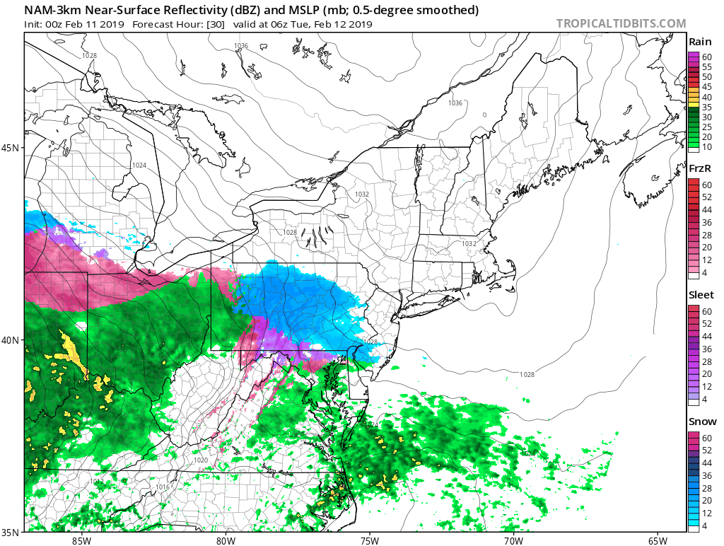
Eventually, a secondary area of low pressure will develop, and move across southeastern New England early Wednesday. This should allow most of the region to get above freezing and change to plain rain before everything winds down around daybreak Wednesday. So, how much snow are we expecting before the changeover?
Cape Cod/Southeast Massachusetts, Southern Rhode Island: 1-2″
I-95 Corridor (Boston/Providence): 1-3″
MetroWest/North Shore: 2-4″
Merrimack Valley/Southern NH/ NH Seacoast: 3-6″
Central NH/Southern ME (Concord/Portland): 4-8″

High pressure builds in behind the storm for late Wednesday and Thursday with dry and cooler conditions. However, another storm follows for Friday. This one looks to be milder, with mainly rain. However, it’s still 5 days away, and the models have been, well, not good, beyond about 3 days this winter, so we’ll obviously have to keep an eye on that one too. But for now at least, it looks like rain. High pressure builds in behind that storm next weekend with dry and colder weather.
Monday: Morning clouds, then becoming partly sunny. High 31-38.
Monday night: Clouds return. Low 13-20.
Tuesday: Cloudy with snow developing in the afternoon, possibly heavy at times. Snow will change to sleet along the South Coast towards evening. High 25-32.
Tuesday night: Snow changing to sleet, freezing rain, and eventually plain rain from south to north before ending by daybreak. Breezy. Temperatures slowly rise at night.
Wednesday: A lingering snow or rain shower is possible, otherwise skies will become partly sunny, breezy. High 39-46, possibly warmer across parts of southeastern Massachusetts and Cape Cod in the morning.
Thursday: Sunshine and a few clouds, still breezy. High 34-41.
Friday: Becoming partly to mostly cloudy with a few rain showers possible. High 43-50.
Saturday: Cloudy and breezy with a chance of rain. High 43-50.
Sunday: Partly to mostly sunny, breezy, and colder. High 29-36.
