You’ve heard the news talking about it all week, and we mentioned it in our Weekly Outlook. A storm is coming on Friday, and it’s going to be a big one.
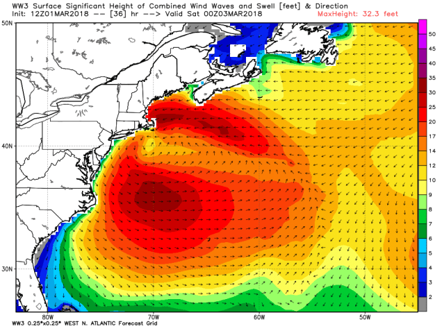
The biggest impacts from this storm will be felt along the coastline. We’ve already got astronomical high tides due to the full moon we had this week. As in the storm churning up the Atlantic and strong winds (more on that in a moment), and you’ve got a recipe for major coastal flooding. Parts of the coastline, especially east-facing shorelines, could see flooding worse than they saw with the storm in early January. Coastal flooding was already observed during the Thursday afternoon high tide without any impacts from the storm. What do you think is going to happen when you have onshore winds of 30-50 mph and 20-40 foot seas? Yeah, nothing good.
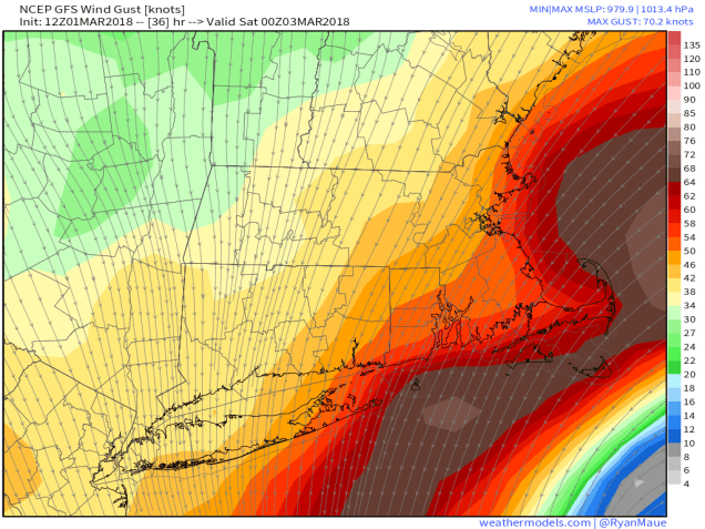
As we mentioned above, strong winds will impact most of the region starting late Thursday night and especially on Friday as the storm begins to intensify in the waters south of New England. High Wind Warnings are already in effect for much of the region. Sustained winds of 25-45 mph with gusts of 60-70 mph are likely, especially near the coastline. Some gusts in excess of hurricane force are possible, especially across Cape Cod. With winds this strong, power outages are likely, so make sure you are prepared for that possibility. Winds may start to diminish a little on Saturday, but as the storm heads southward and grows even larger, it will continue to produce gusty winds across the region right through the weekend.
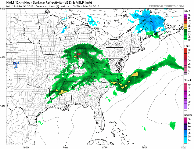
In addition to the damaging winds and coastal flooding, heavy rain is also expected across the region. Rain will move in after midnight tonight, and continue for much of the day on Friday, heavy at times. The storm is drawing moisture northward from the Gulf of Mexico and the tropics, and as it moves into the relatively cooler air in place here, it will wring it out across the region. We’re looking at rainfall totals of 1 to 3 inches across the region, with some heavier amounts possible, especially across southeastern Massachusetts and Rhode Island. We’ve already had a wet start to the year, and the ground is close to saturated, so this will likely result in flooding in many areas. Rivers are also running fairly high, especially for this time of year, so river flooding will also become a concern.

Now we get to the tricky part of the forecast, where the greatest uncertainty lies – snowfall. There’s not a lot of cold air in place when the storm moves in, and we don’t have a big high pressure area to the north to help keep any cold air around. However, there is some cold air aloft, and as the system gets cranked up, it may try to tap into that cold air. As we get into some of the heavier bands of precipitation, it may drag some of that cold air down, changing the rain to snow in some areas. This isn’t the type of thing we can predict well in advance, so trying to pinpoint now is futile. However, don’t be surprised if some places change over to snow for a while during the day on Friday. Of course, some of the higher elevations, especially in the Worcester Hills, Monadnocks, and Berkshire, should have enough elevation to have quite a bit of snowfall from this system. It will be the heavy, wet snow that nobody likes either. You know, the type that weights down tries and power lines, making it even easier for them to snap when you get wind gusts of 50 mph or more. The other thing we’re concerned about with snowfall is what happens on the backside of the system. As the storm starts to pull away late Friday, colder air will settle in behind the system. The questions are: 1. How quickly does that cold air move in? and 2. How much precipitation is still around? Right now, we wouldn’t be surprised to see some locations pick up a quick 1-3 inches, possibly even more. There’s also a chance that the colder air moves in too late, and many places see little to no snow at all. The worst-case scenario, and we’re not completely ruling it out yet, is that places change over to snow in a burst of heavy precipitation during the afternoon (like we mentioned above), and never change back. If that were to happen (and the place where that would be possible would be mainly north and west of Boston), then very heavy snowfall amounts would become more likely. For the record, we’re not expecting this, but we are a little wary that it’s at least possible.

By Monday, high pressure builds in, and everything calms down. We may have another storm to deal with towards the middle of next week, but we’ll worry about that one after we get through this one.
