
Well, looks like there’s going to be yet another parade in the City of Boston. It also looks like Mayor Marty Walsh didn’t consult with any meteorologists before announcing it, because the weather on Tuesday at 11am doesn’t look pretty at all. But Tuesday’s not the only day we need to worry about, there’s also Thursday (which could be a bigger threat) along with Saturday and Sunday. So, let’s get right to it.
The week starts off with high pressure on Monday, giving us some sunshine, but cooler temperatures. By Tuesday, low pressure starts heading into the Great Lakes, with a warm front extending eastward. As is typical of this time of year, the warm front will have a hard time moving northward, which will create a mess across inland areas, as cold air remains trapped at the surface while warmer air moves in aloft.From Boston southward, this will be mainly a rain storm, with some snow possible at the start Tuesday morning. Inland though, especially north and west of 495, it’ll be a much different story. Accumulating snow is likely, which a change to sleet and freezing rain Tuesday evening, The wintry mix may continue through much of the overnight, especially across southern NH, before the warmer air finally moves in Wednesday morning, allowing a change to plain rain before it ends around midday. We’re not looking at a lot snow, mainly 1-3″ in most spots, maybe a little more into southern NH, but the sleet and freezing rain could make for some slippery travel Tuesday night. If you’re heading in for the parade, expect some snow changing to rain, gusty easterly winds, and temperatures in the middle 30s.
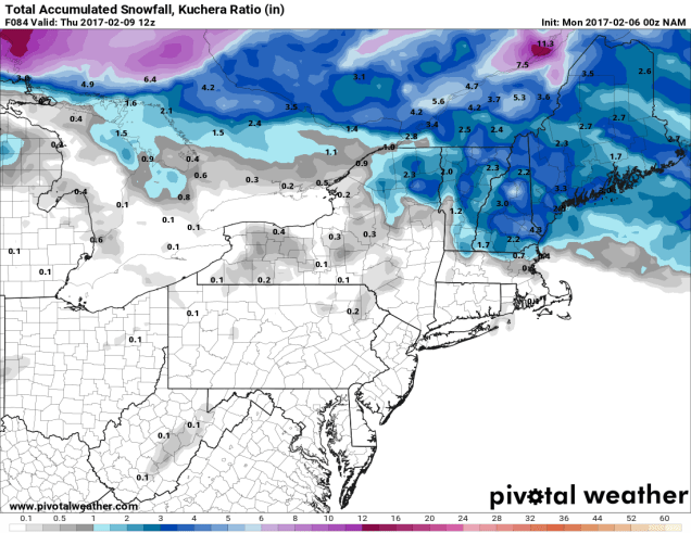
Once that storm moves out, we turn our eyes to the south for Thursday. Most of the models show a storm system moving off the Southeast coast and heading northeastward. Most of the models also have it passing close enough to spread some snow into at least southern New England. The question is, how close does it get? That could mean the difference between a few inches from Boston southward (as some models show), , 3-6″ across most of eastern New England as another model shows, or a widespread 6-12″ across the entire region, as another model is currently showing. For now, we’re going to lean towards the lighter side, but we’ll have to keep a close eye on the models for the next few days to see which way they are trending. As usual, if it looks like a threat, we’ll write another post about it.
Once that system goes by, then high pressure builds in for Friday with much colder conditions, but an Alberta Clipper will head our way for Saturday. This will bring in some light snow, but shouldn’t be a big storm. Another system quickly moves out of the Great Lakes behind that one for Sunday, but this one looks warmer, with more rain than snow. However, it’s nearly a week away, so a lot can and will change, and we’ll need to keep an eye on this one too.

Monday: Plenty of sunshine to start, clouds start to move in during the afternoon. High 28-35.
Monday night: Becoming cloudy, some flurries or freezing drizzle are possible. Low 21-28 in the evening, then temperatures hold steady or slowly rise overnight.
Tuesday: Snow developing, quickly changing to rain from Boston southward, gradually changing to a mix of sleet and freezing rain north and west of Boston late in the day. High 29-36 north and west of I-95, 36-43 south and east of I-95.
Tuesday night: Freezing rain continues across southern NH, changing to plain rain close to daybreak, elsewhere, light rain is expected overnight. Temperatures slowly rise across the region.
Wednesday: Showers ending around midday, otherwise remaining mostly cloudy. High 41-48 north and west of I-95, 48-55 south and east of I-95.
Thursday: Cloudy with a chance of snow. High 26-33.
Friday: A mix of sun and clouds, chance for a few snow showers. High 18-25.
Saturday: Cloudy with a chance for some light snow, possibly changing to rain across Cape Cod and the South Coast. High 30-37.
Sunday: Cloudy with a chance of rain or snow. High 32-39.
