(Note: This post was edited to reflect the fact that Hermine was upgraded to a hurricane at 3pm EDT)
We’re just about to start the Labor Day Weekend, traditionally summer’s last gasp around here, and the big question on everyone’s mind is “Will Hurricane Hermine ruin my plans?” The short answer is “maybe.”

First, let’s start off with the basic facts. As of 3pm EDT, Hurricane Hermine was centered about 115 miles south-southwest of Apalachicola, Florida, and was moving towards the north-northeast at 14 mph. The storm has maximum sustained winds of 75 mph, and some more strengthening is possible before landfall just east of Apalachicola tonight.A Hurricane Warning is in effect for the coast of Florida from Mexico Beach to the mouth of the Suwanee River. Hurricane watches and Tropical Storm Warnings are also in effect for much of the remainder of the Florida Gulf Coast, as well as much of the Atlantic Coast from northeastern Florida up to North Carolina.

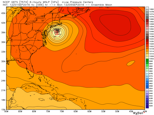
OK, now that we’ve got the facts spelled out, here’s what we’re fairly sure about: Hermine will likely make landfall a little east of Apalachicola, Florida tonight. This will be the 1st hurricane to make landfall in Florida since Hurricane Wilma on October 24, 2005, ending Florida’s record 11-year “hurricane drought.” Once it makes landfall it will move up across Georgia and into the Carolinas, slowly weakening while dropping heavy rainfall on the region. Flooding is almost a certainty in some areas. The center of Hermine should move back out into the Atlantic off the North Carolina coastline, possibly as far north as Norfolk, Virginia by late Saturday. Once off the coast, the storm will likely drift northward and then stall east of the Delmarva Peninsula on Sunday. This is where things get tricky.

We’ve gone over what is going on currently, and what we’re fairly sure will happen over the next 2-3 days. Now, we’ll delve into the parts that we don’t have a handle on yet. Once the storm stalls east of the Delmarva Peninsula, we have a lot of questions that just can’t be answered right now. Where does it actually stall? How long does it stall? Which way does it drift once it does stall? How strong will it be? How large will the wind field be? How large will the precipitation field be? These are all important details that have a HUGE effect on the forecast. Unfortunately, we won’t have a better idea of these details for another 24 or even 48 hours.

While we’re not expecting Hermine to be a hurricane once its off the Delmarva Peninsula, it could still be a tropical storm once it is east of the Delmarva Peninsula. More likely, it will become extratropical. What does that mean? To put it in simple terms, it will be more like a typical Nor’easter around here.
If you’ve got Labor Day Weekend plans, don’t scrap them just yet, but have a backup plan ready. The farther north your plans are, the less likely that you’ll be impacted. However, the closer you are to the South Coast or the Cape, the greater the chance that you may be dealing with gusty winds and/or rainfall. (Rough surf is a virtual lock at this point, so staying out of the water is probably a good idea).
We should be able to provide an update this weekend, once things become a little more certain.