Weekly Outlook: March 23-29, 2026

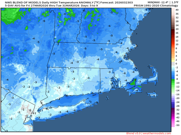
The first full week of Spring won’t feature any big storms or extreme temperatures, but it won’t be a quiet week either.

Some wintry precipitation is expected today, but with little accumulation. Image provided by WeatherBell.

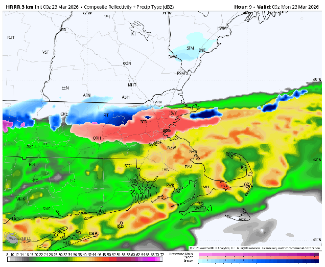
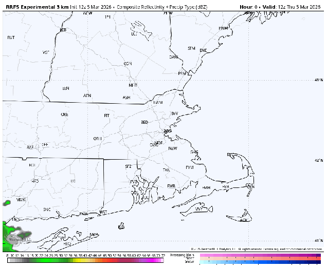
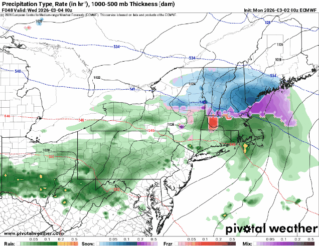
A wave of low pressure riding along a stalled out frontal system south of New England will bring some snow or rain showers in today. With most of the snow falling during the daytime, we’re not expecting much, if any, accumulation, and if there is any, it will be mainly on grassy surfaces. A trough of low pressure trailing the system may produce some additional snow showers this evening and tonight, then we’ll start to clear out later tonight as high pressure builds in with dry and cool conditions for Tuesday. Clouds start to stream back in on Wednesday as a weak trough of low pressure heads our way from the Midwest. A few widely scattered showers may accompany this trough, but most of the region should remain dry. A cold front then moves in on Thursday, with some rain late Thursday and Thursday night, possibly ending as some snow early Friday, then high pressure builds in for the weekend with chilly but dry conditions.

Below normal temperatures return for the end of the week and the weekend. Image provided by weathermodels.com

Monday: Plenty of clouds, breezy, some snow showers or sleet likely from the Mass Pike northward, rain changing to snow showers elsewhere. High 35-42.

Monday night: Snow showers gradually taper off and end, skies start to clear out late at night. Low 25-32.

Tuesday: Becoming partly to mostly sunny, though some clouds may start to move back in late in the day. High 39-46.

Tuesday night: Partly cloudy. Low 27-34.

Wednesday: Partly sunny, breezy. High 45-52.

Wednesday night: Becoming mostly cloudy. Low 34-41.

Thursday: Mostly cloudy, becoming breezy, showers possible late in the day. High 51-58.

Thursday night: Plenty of clouds with showers likely, possibly changing to snow before ending around daybreak, breezy. Low 36-43.

Friday: Partly sunny, breezy. High 47-54.

Saturday: Sunshine and some afternoon clouds. High 34-41.

Sunday: A mix of sun and clouds. High 41-48.

Weekend Outlook: March 20-23, 2026

Spring officially begins at 10:46am on Friday, but that doesn’t really mean that we’re done with winter weather.

Record highs and summerlike temperatures are likely this weekend across a majority of the nation…..except the Northeast and Great Lakes. Image provided by weathermodels.com

While the rest of the nation gets an early taste of summer for the next few days, here in New England, we’re reminded that Spring is usually delayed compared to everywhere else. A weak system will pass north of the region tonight generating some clouds and possibly a few flurries, favoring areas north of Route 2. We’ll clear out late at night, but clouds will quickly move back in Friday afternoon as another low pressure system heads our way. We’ll see some rain moving in by evening, ending around daybreak Saturday. We’re not expecting heavy rain from this, but every little bit helps put a dent in the ongoing drought. While we should see some sunny breaks developing Saturday afternoon, plenty of clouds will hang around as yet another system heads our way. This system could be a little trickier. Some models show a mild day with temperatures topping 60 before some rain moves in during the afternoon ahead of a cold front. Other say that it might be cold enough to start as some snow across parts of southern New Hampshire or even the Merrimack Valley, changing to rain, then back to snow or sleet behind the cold front from the Mass Pike northward before everything winds down early Monday. We’re going to lean towards the milder scenario for now, but with low confidence. Gradual clearing is expected during the day Monday as the cold front pushes offshore.

The models all have different ideas for what to expect Sunday evening. Images provided by Pivotal Weather.

Thursday night: Partly cloudy, slight chance for a flurry north of Route 2. Low 27-34.

Friday: Morning sun, then clouds stream back in, rain developing late in the day, becoming breezy. High 47-54.

Friday night: Periods of rain and showers, ending before daybreak. Low 35-42.

Saturday: Intervals of clouds and sunshine. High 47-54.

Saturday night: Partly to mostly cloudy. Low 31-38.

Sunday: Plenty of clouds with showers developing in the afternoon. High 47-54.

Sunday night: Rain may change to snow and/or sleet before ending overnight, especially north of the Mass Pike. Low 30-37.

Monday: Gradual clearing, breezy. High 41-48.

Weekend Outlook: March 13-16, 2026

After an early taste of Spring this week, Mother Nature is going to remind us that it’s still March, and astronomical Spring doesn’t start for another week.

Average high temperatures for mid-March are in the middle 40s. Image provided by weathermodels.com

A wave of low pressure will ride along the cold front that crossed the region earlier today, bringing in some additional precipitation this evening. We’ll see rain changing over to sleet and then snow during the late afternoon and evening, ending before midnight. Some places could see a coating to perhaps an inch of accumulation, mainly on grassy surfaces, before everything winds down. We’ll see some clearing overnight, but clouds quickly move back in on Friday. A fast-moving system will bring in some snow or rain showers Friday evening. There probably won’t be much accumulation, and what little there is, will be mainly on grassy surfaces, and mainly north of Route 2. Gusty winds behind the system will bring colder air back in for Saturday, with wind chills in the 20s and 30s during the daytime as air temperatures only get into the lower to middle 40s. Sunday looks to be a dry and seasonably cool day, but more changes are coming.

Wind gusts of 35-45 mph or higher are expected Saturday afternoon. Image provided by Weathermodels.com

A storm system that may produce blizzard conditions across the Great Lakes will begin heading towards southeastern Canada later Sunday. We’ll see some rain moving in Sunday night ahead of a warm front. Once the front moves through, rain will taper off Sunday morning, with gusty southerly winds bring much warmer air back in, with many places likely reaching 60 again on Monday. As a cold front trailing the system heads our way, we’ll see rain moving back in late in the day, and it could be heavy, with a rumble of thunder possible as well. While we do need the rain to help put a dent in the ongoing drought, the ground remains frozen in much of the region, so a lot of the rain won’t seep in. Many rivers are also running high due to some recent rain and melting snow, so another round of heavy rain could lead to some flooding.

Much of the region could see an inch or more of rainfall on Monday. Images provided by Pivotal Weather.

Thursday night: Snow, sleet, and rain ending during the evening, less than 1 inch accumulation, mainly on grassy surfaces, skies clear out overnight. Low 24-31.

Friday: Sunny in the morning, clouds return in the afternoon, snow or rain showers possible by evening, becoming breezy. High 36-43.

Friday night: Partly to mostly cloudy and breezy with some snow or rain showers likely, mainly north of Route 2, and mostly before midnight. Low 30-37.

Saturday: Sunshine and a few clouds, windy. High 40-47.

Saturday night: Clear skies, clouds may start to move back in late at night. Low 23-30.

Sunday: Becoming partly to mostly cloudy. High 38-45.

Sunday night: Cloudy with rain developing. Low 31-38 during the evening, temperatures start rising after midnight.

Monday: Rain tapers off early, then mostly cloudy and windy with more rain by late in the day, possibly a rumble of thunder. High 54-61, coolest across the South Coast and Cape Cod.

Weekly Outlook: March 9-15, 2026

March is the month where we transition from winter to spring, but this week, we’re going to go the opposite direction – from spring to winter.

Temperatures could reach 70 in some areas on Tuesday, Image provided by Weathermodels.com

We start the week off with some unseasonably mild weather for Monday and Tuesday with high pressure in control. Temperatures will likely top 60 across inland areas, with 50s or even 40s near the coast and across southeastern Massachusetts, where southwest winds are blowing across the still-chilly Atlantic. By late Tuesday, a backdoor cold front will begin dropping southward as high pressure builds into eastern Canada, meaning a much cooler day is expected, especially along the coast. At the same time, low pressure will be moving into the Great Lakes, so we’ll have plenty of clouds, with a few showers possible during the day, more likely at night. That backdoor cold front will begin to lift northward again as a warm front Wednesday night, but our warm weather redux will be short-lived. The aforementioned low pressure system will drag a strong cold front across the region early Thursday, with rain ahead of it, ending in the afternoon. After a mild start to the day, temperatures will drop during the daytime hours. After a cool day on Friday, another system moves into the Great Lakes, with milder weather returning for Friday night and Saturday before another cold front brings in another round of showers, possibly mixed with some wet snow to start. Another system quickly follows on Sunday, with some additional rain or snow possible.

Temperatures Wednesday afternoon could be 15-30 degrees cooler than Tuesday afternoon behind a backdoor cold front. Image provided by WeatherBell.

Monday: Partly to mostly sunny. High 58-65, cooler near the South Coast and Cape Cod.

Monday night: Partly to mostly cloudy across Cape Cod, clear to partly cloudy elsewhere. Low 34-41.

Tuesday: Partly to mostly sunny. High 64-71, cooler near the South Coast and Cape Cod.

Tuesday night: Clear during the evening, then increasing clouds overnight. Low 36-43.

Wednesday: Becoming mostly cloudy and breezy. High 51-58, warmer inland, especially well south and west of Boston.

Wednesday night: Plenty of clouds with some showers likely, breezy. Low 46-53 during the evening, temperatures may rise overnight.

Thursday: Breezy with rain possibly mixed with snow before ending north and west of Boston. High 51-58 early, temperatures drop in the afternoon.

Thursday night: Becoming clear. Low 22-29.

Friday: Morning sun, then increasing clouds, rain or snow showers possible at night, breezy. High 38-45.

Saturday: Breezy with showers ending, some late-day sunny breaks. High 40-47.

Sunday: Partly to mostly cloudy with a chance for rain or snow showers. High 42-49.

Weekend Outlook: March 6-9, 2026

A rather messy storm will impact the region tonight and Friday, but milder weather is on the way.

A wintry mess is on the way for tonight and Friday morning. Image provided by the National Weather Service office in Norton, MA.

A frontal system is stalled out south of the region as high pressure in Atlantic Canada sends cold weather our way once again. Meanwhile, low pressure moving across the Midwest is sending some rain our way through the afternoon. As the colder air continues to filter in this evening, first at the surface, and then aloft, we’ll see rain changing to sleet, and possibly some freezing rain, mainly north of the Mass Pike, with mostly rain to the south. The best chance for freezing rain will be across the hills in Worcester County up into the Monadnocks of southwestern New Hampshire. As the colder air moves in aloft, a change to snow is expected, with rain changing to sleet south of Boston, though areas near the South Coast will likely stay mostly rain. Precipitation winds down Friday morning as the wave of low pressure pulls away. We’re looking at 2-4 inches of snow and sleet across southern New Hampshire and northern Massachusetts, mainly north of Route 2, with a coating to 2 inches south of there. Friday afternoon and evening will be cloudy, chilly, and damp, with some drizzle or freezing drizzle at times.

A wintry mess will create problems for the Friday morning commute. Loop provided by WeatherBell.

Saturday will be the start of the transition to milder weather. A stronger low pressure system will head into the Great Lakes, with southwest winds developing ahead of it. The clouds will hang tough for much of the day, though there could be a few sunny breaks, but temperatures will turn milder, likely topping 50 in many areas, though areas near the South Coast will stay in the 40s, as a southwest wind will be blowing off of the still-chilly Atlantic. A warm front moves through Saturday night, accompanied by a few rain showers, but it will keep temperatures mild through the night, likely staying in the 40s or even 50s during the overnight hours, helping to melt the snow we still have on the ground. A cold front moves through Sunday morning, possibly with another shower or two, but we’ll clear out behind it, with temperatures remaining mild, well into the 50s inland, 40s near the South Coast. High pressure then builds in for Monday with sunshine and mild temperatures, possibly reaching 60 in a few spots.

Monday is shaping up to be a fantastic day across the region. Image provided by weathermodels.com

Thursday night: Cloudy with rain likely, changing to sleet/freezing rain north of the Mass Pike, and eventually snow north of Route 2. Low 27-34.

Friday: Snow, sleet, freezing rain, and rain ending during the morning, cloudy with some drizzle or freezing drizzle and fog through the afternoon, breezy at times. Snow and sleet totals 2-4 inches north of Route 2, a coating to 2 inches south of Route 2, little to no accumulation across southeastern Massachusetts and southern Rhode Island. High 32-39.

Friday night: Plenty of clouds, some drizzle or freezing drizzle likely along with more fog. Low 29-36.

Saturday: Clouds and a few sunny breaks. High 43-50.

Saturday night: Mostly cloudy with a few showers, becoming breezy. Low 38-45 in the evening, temperatures rise overnight.

Sunday: Morning clouds and fog, possibly a shower, then becoming partly to mostly sunny in the afternoon. High 50-57, cooler across Cape Cod.

Sunday night: Clear skies. Low 31-38.

Monday: Sunshine and a few clouds. High 55-62, cooler across the South Coast and Cape Cod.

Weekly Outlook: March 2-8, 2026

An active weather pattern will provide us with a little bit of everything this week.

Much of the region could see a pretty decent amount of precipitation this week. Image provided by weathermodels.com

The week starts off quiet with high pressure in control giving us a rather chilly day, but that won’t last too long. A wavy frontal system will start to lift northward on Tuesday as a wave of low pressure rides along it. With cold air in place, we’ll see snow moving in Tuesday afternoon, but it will quickly change to rain south of the Mass Pike as warmer air moves in. North of the Pike, the colder air will take a little longer to scour out, but warmer air will move in aloft, so we’ll likely see a period of freezing rain Tuesday evening before a change to plain rain at night before the precipitation comes to an end. Wednesday looks like a calmer day, and likely a bit milder, with some sunshine. That front will lift northward as a warm front on Thursday, bringing us a mild day with more rain. While this will help melt some of the glacier that we still have in place, it may also cause some problems, as the ground remains frozen, so that water will have nowhere to go. While we’re not going to have widespread flooding, there could be some issues, especially along some of the rivers as the ice breaks up and starts to flow downstream, with ice jams possibly resulting in some flooding issues. The front drops southward as a backdoor cold front late Thursday and Friday, with another wave of low pressure moving along it. As the colder air moves back in, we could see a period of sleet or freezing rain across the interior once again. The front may lift back northward as a warm front on Saturday, before a stronger cold front moves in from the northwest on Sunday.

Tuesday’s afternoon commute could be messy, especially north and west of Boston. Images provided by Pivotal Weather.

Monday: Sunshine and a few clouds. High 21-28.

Monday night: Clear and cold, clouds start to drift in late at night. Low 8-15.

Tuesday: Becoming mostly cloudy, light snow developing in the afternoon, quickly changing to rain south of the Mass Pike. High 34-41.

Tuesday night: Cloudy with rain likely south of the Mass Pike, snow changing to freezing rain and possibly plain rain north of the Mass Pike, ending before daybreak. Low 27-34 during the evening, temperatures hold steady or slowly rise overnight.

Wednesday: Clouds give way to some sunshine, chance for a few showers. High 43-50, cooler along the coast and across Cape Cod.

Wednesday night: Becoming mostly cloudy, showers developing late at night. Low 28-35.

Thursday: Cloudy with some showers likely. High 43-50.

Thursday night: Rain likely, possibly changing to sleet or freezing rain across southern New Hampshire and interior northern Massachusetts. Low 29-36.

Friday: Cloudy with some areas of freezing drizzle or sleet across the interior, plain drizzle elsewhere. High 35-42.

Saturday: Plenty of clouds with more showers, possibly some freezing rain well inland in the morning. High 47-54.

Sunday: Mostly cloudy with more showers possible. High 51-58, cooler across Cape Cod.