Weekend Outlook: June 27-30, 2025

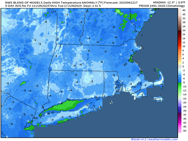
The heat and humidity are gone, with cool and damp weather return, the hot and humid weather could make a return by the end of the weekend.

Temperatures are 20-30 degrees colder this afternoon than they were at this time yesterday. Image provided by Weathermodels.com

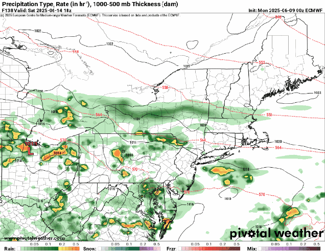
The front that ended the heat wave moved through yesterday and has settled offshore, with high pressure building in to the north. This has shifted winds into the east and northeast, bringing much cooler air in, and it will hang around into Friday. As disturbances ride along the front, we’ll have episodes of showers into Saturday, though the vast majority of the time will remain dry. As the high slides offshore, winds will start to shift into south and southwest on Saturday, allowing temperatures to warm into the 70s in many areas, especially south of the Mass Pike, though we’ll still have plenty of clouds and a few showers, especially north of the Mass Pike, but dewpoints will climb back into the 60s, perhaps even lower 70s across the region. We should see a little more in the way of sunshine on Sunday, allowing temperatures to get back into the 80s in many areas. By Monday, the very warm and humid weather will return, with highs well into the 80s and dewpoints in the 60s and lower 70s across much of the region resulting in another moderately uncomfortable day.

Most (but not all) of the models show drier weather moving in Saturday afternoon. Images provided by Pivotal Weather,

Thursday night: Plenty of clouds with a few showers possible. Low 56-63.

Friday: Intervals of clouds and sunshine, slight chance for a shower. High 66-73.

Friday night: Mostly cloudy with some showers likely. Low 55-62.

Saturday: Mostly cloudy with a chance for more showers, mainly in the morning. High 73-80 south of the Mass Pike, 65-72 north of the Pike.

Saturday night: More clouds with a few more showers possible. Low 60-67.

Sunday: Becoming partly sunny. High 75-82.

Sunday night: Partly cloudy. Low 58-66.

Monday: A mix of sun and clouds. High 81-88, cooler across Cape Cod.

Weekend Outlook: June 13-16, 2025

The calendar says it’s mid-June, but the forecast feels like Groundhog Day, because for the 13th week in a row, we’re here to tell you that it’s going to rain on Saturday.

No matter which model you look at, they all have rain for at least part of the region Saturday morning. Images provided by Pivotal Weather.

After a warm day today we have a cold front moving through with just some clouds and possibly a stray shower through the evening. That front will settle just offshore and stall out, with cooler weather filtering in behind it for Friday, with temperatures running 10-15 degrees cooler than today, close to or a little below where we should be in mid-June. Friday should be dry, with sunshine filtered through some high clouds. A weak area of low pressure will ride along the front Friday night and early Saturday, bringing some rain into the region along with rather cool conditions. The rain should taper off during the morning, but east winds off the Atlantic will keep clouds in place Saturday afternoon with a little drizzle at times, and temperatures only in the 60s, possibly upper 50s near the coast. For Sunday and Monday, we’ll be stuck in between high pressure to the north and another weak low pressure system riding along that front to our south. The result will be plenty of clouds, possibly a few showers, and temperatures remaining on the cool side, though Monday will likely be a little milder. The good news is that temperatures should warm up quite a bit as we get towards the middle of next week.

Temperatures will be cooler than normal for the next few days. Image provided by weathermodels.com

Thursday night: Slight chance for a shower near the South Coast during the evening, otherwise clear to partly cloudy with increasing clouds late at night. Low 55-62.

Friday: A mix of sun and clouds. High 72-79, a little cooler across Cape Cod.

Friday night: Becoming mostly cloudy, showers develop after midnight. Low 52-59.

Saturday: Cloudy and much cooler with showers likely before midday, then a few showers and some patchy drizzle in the afternoon. High 60-67.

Saturday night: Mostly cloudy. Low 49-56.

Sunday: More clouds than sunshine, slight chance for a shower or some drizzle. High 62-69, coolest along the coast.

Sunday night: Partly to mostly cloudy. Low 51-58.

Monday: Mostly cloudy, a few sunny breaks, some showers possible, mainly late in the day. High 67-74.

Weekly Outlook: June 9-15, 2025

We’ve got a fairly typical week of weather for mid-June coming up across the region.

Thursday looks like the warmest day this week with many locations likely getting well into the 80s. Image provided by WeatherBell.

We start the week off on a cloudy and cool note with a warm front off to our south and a weak upper-level disturbance moving through, possibly producing a few widely scattered showers. The warm front moves through late tonight and early Tuesday as low pressure passes north and west of the region. This will result in a warmer and more humid day, with some showers and thunderstorms expected ahead of a cold front trailing that low pressure system. Behind that front high pressure builds in with warmer and drier weather for Wednesday and Thursday with temperatures well into the 70s, with some 80s, especially on Thursday. Although we’ll have sunshine, smoke from Canadian wildfires may result in hazy skies both days, and my keep temperatures a little lower than we are currently expecting.

Smoke from Canadian wildfires will impact much of the Northeast on Wednesday. Image provided by NASA.

The end of the week is a lot more uncertain at this point. We’ll have a big high pressure area across southeastern Canada, and a frontal system stalled out south of New England, with waves of low pressure riding along it. Where that front stalls out and has the waves move through determines when (or if), we get any rain (and how much) next weekend. Friday should be a mostly dry day with the front moving through, though there could be a few showers accompanying it. It’s the weekend that has the most uncertainty. Some models keep Saturday dry, some have some showers, some heave steadier rain especially late in the day. Sunday is fairly similar, with some models showing a decent amount of rain, some having just some showers, and some keeping us mostly dry. Temperatures will also be dependent on the position of the front and waves riding along it, along with the timing and amount of any rainfall. Don’t go cancelling any weekend plans just yet as it’s still several days away and there’s a lot of uncertainty, but have a backup plan ready just in case.

Are we in for yet another rainy Saturday? It remains to be seen. Images provided by Pivotal Weather.

Monday: Areas of morning fog, otherwise mostly cloudy with a few showers possible. High 63-70, coolest along the coast.

Monday night: Overcast with a few showers and some dense fog possible. Low 53-60.

Tuesday: Plenty of clouds with showers and some thunderstorms. High 67-74.

Tuesday night: Showers end in the evening followed by clearing after midnight. Low 55-62.

Wednesday: Plenty of sunshine, breezy. High 76-83, a little cooler across Cape Cod.

Wednesday night: Mostly clear. Low 60-67.

Thursday: Sunshine and some afternoon clouds, breezy. High 78-85, a little cooler across Cape Cod.

Thursday night: Partly to mostly cloudy. Low 56-63.

Friday: Intervals of clouds and sun. High 72-79.

Saturday: Mostly cloudy with some showers possible. High 65-72.

Sunday: More clouds than sun with a chance for more showers. High 65-72.

Weekend Outlook: June 6-9, 2025

Someone call Ripley, because Believe It or Not, there’s rain in the forecast for part of the weekend.

More rain is expected for parts of the region Friday and Saturday. Image provided by WeatherBell.

After a hot and somewhat humid day today, changes are on the way as a slow-moving cold front makes its way toward the region. We’ll see clouds become more numerous tonight and Friday, with some showers and thunderstorms likely on Friday, especially in the afternoon, and mainly north of the Mass Pike. Some of these storms may produce strong winds and heavy rain which could lead to areas of flooding, so if you’ve got outdoor plans, keep an eye on the radar. It’ll still be quite warm and humid, but not as hot as today.

Some severe storms are possible on Friday, especially across the interior. Image provided by the Storm Prediction Center.

The cold front finally moves through on Saturday, accompanied by some additional showers, but they shouldn’t be that heavy. They’ll also be accompanied by cooler temperatures behind the front. Sunday will be the pick of the weekend as high pressure builds in with more comfortable conditions, though there will still be some clouds around as an upper-level disturbance crosses the region. We also have more smoke from Canadian wildfires drifting in on Sunday, resulting in hazy skies at times. Monday is a little uncertain at the moment. Many of the models had been showing high pressure remaining in control with a weak low pressure system passing well to the south, but some of those models are bringing the system a lot farther northward now, possibly bringing in more showers on Monday. We’re going to be cautiously optimistic for now that it should remain mostly dry, but with low confidence.

Will high pressure or low pressure be in control on Monday? Images provided by Pivotal Weather.

Thursday night: Partly to mostly cloudy, a few showers or thunderstorms possible during the evening. Low 61-68.

Friday: Some morning sun, otherwise becoming mostly cloudy with showers and thunderstorms developing, some could produce heavy downpours and strong winds. High 78-85, cooler along the coast.

Friday night: Mostly cloudy, showers and thunderstorms wind down before midnight. Low 57-64.

Saturday: Plenty of clouds with more showers likely. High 70-77.

Saturday night: Any lingering showers end in the evening, then becoming partly cloudy. Low 54-61.

Sunday: Intervals of clouds and hazy sunshine. High 70-77, cooler across Cape Cod.

Sunday night: Partly to mostly cloudy. Low 52-59.

Monday: Partly sunny. High 66-73.

Weekly Outlook: June 2-8, 2025

“Summer’s here and the time is right for dancing in the street”

Climatological summer began yesterday, and we’ve got some summer-like weather finally on the way.

Thursday looks to be the warmest day this week. Image provided by WeatherBell.

We have one more cool day today as low pressure continues to slowly pull away from the region. With northwest winds, temperatures will be a little below normal for early June, and we’ll still have some clouds around, especially in the afternoon, with an upper-level low pressure area nearby. Things start to change for Tuesday though with high pressure building in. We’ll have more sunshine, and southwest winds will start to usher milder air in. Winds aloft will still be out of the northwest, so we could see some smoke aloft from Canadian wildfires start to drift in, resulting in some hazy conditions in the afternoon. Wednesday should be a little warm and also a bit more humid, but still comfortable, but we’ll have a better chance for hazy skies as more smoke flows in from the wildfires in central Canada.

Models show the highest concentration of smoke over our area around midday Wednesday. Image provided by weathermodels.com.

By Thursday a cold front will begin to approach from the northwest, but ahead of it should be the warmest and most humid day of the week, temperatures likely reaching or exceeding 90 in many areas away from the South Coast, and dewpoints should get into the 60s in many locations. That front may trigger some showers and thunderstorms during the afternoon and evening. The front will stall out nearby, with keeping temperatures on the mild side for Friday, but not as warm as the previous few days. A wave of low pressure riding along the front may bring some additional showers and thunderstorms later Friday into Saturday. We know, another Saturday with rain. Save your complaints, we only tell you what to expect, we can’t control it. The front finally pulls offshore later Saturday, and high pressure builds in for Sunday with cooler and drier conditions.

Another Saturday with some rain? The models are leaning that way right now. Images provided by Pivotal Weather.

Monday: Sunshine and some afternoon clouds. High 64-71.

Monday night: Clear skies. Low 46-53.

Tuesday: Plenty of sunshine, becoming hazy late in the day. High 71-78, cooler across Cape Cod.

Tuesday night: Clear skies, hazy. Low 51-58.

Wednesday: Sunshine filtered through smoke and haze. High 80-87, cooler across the South Coast and Cape Cod.

Wednesday night: Clear skies, hazy. Low 57-64.

Thursday: Partly sunny, still hazy at times, chance for some late-day showers and thunderstorms. High 84-91, cooler across the South Coast and Cape Cod.

Thursday night: Any showers or storms end in the evening, otherwise partly cloudy. Low 60-67.

Friday: Becoming mostly cloudy, showers developing late in the day. High 78-85, cooler across Cape Cod.

Saturday: Plenty of clouds with some showers likely, tapering off late in the day. High 72-79, cooler across Cape Cod.

Sunday: Partly to mostly sunny. High 71-78, cooler across Cape Cod.