We’ve got a fairly complicated forecast for the final days of Spring and initial days of Summer.
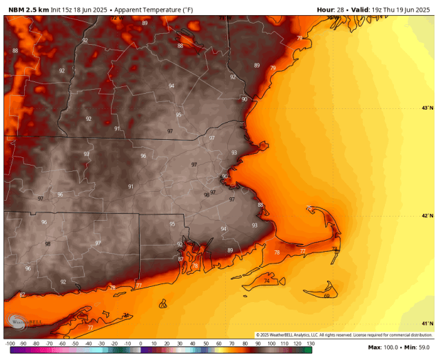
A warm and humid airmass has settled into the region, and it will be here into Thursday. We’ll have plenty of clouds through the evening with a few showers and possibly a rumble of thunder as a weak disturbance moves across the region. These showers should end before midnight, then we’ll see some fog developing. Once the fog burns off Thursday morning a hot and humid day is expected under partly to mostly sunny skies. Gusty southwest winds will help send temperatures into the upper 80s and lower 90s in much of the region, except along the South Coast and Cape Cod, where winds off the water will keep temperatures a little cooler. Dewpoints well get into the 60s and lower 70s, resulting in the heat index reaching the middle to upper 90s in many areas. A Heat Advisory has been issued for parts of the region as a result.

A cold front will move across the region late in the day, triggering some showers and thunderstorms during the late afternoon and evening. A few of these storms may produce strong winds, heavy downpours and some hail, but it looks like the best chance for severe storms will be off to our west. If the front were to move in a little faster than we currently expect, the odds for severe weather would rise, since it would be arriving around the time of maximum heating. Behind the front, drier air settles in for Friday, and while it won’t be as hot, it will still be quite warm. As we get to Saturday, it looks like we will finally break our streak of wet Saturdays with sunshine, mild temperatures, and lower humidity, but that doesn’t mean the entire weekend will be dry.
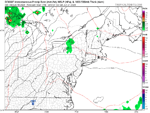
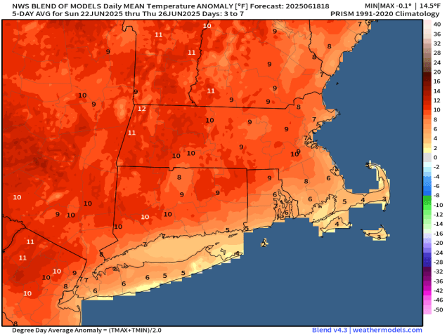
Forecast models have been showing the potential for a cluster of potent thunderstorms to develop across the Northern Plains Friday evening which would then race across the Northern Great Lakes on Saturday before diving into New England after midnight Saturday night. While they should be weakening by the time they get here, don’t be surprised if you’re awakened early Sunday morning by frequent lightning and some heavy downpours. Once those storms move offshore, skies will become partly to mostly sunny again with another dry and warm day expected. Things change again by Monday. A ridge of high pressure will start to build in, resulting in heat and humidity returning on Monday, and possibly for at least a few more days beyond that heading into next week. We’ll have more on that in our Weekly Outlook early Monday morning.
Wednesday night: Partly to mostly cloudy, chance for a few showers during the evening, areas of fog develop overnight, muggy. Low 61-68.
Thursday: Becoming mostly sunny, hot, and humid, showers and thunderstorms possible late in the day, breezy. High 87-94, cooler along the South Coast and across Cape Cod.
Thursday night: Showers and thunderstorms expected during the evening, clearing overnight, breezy. Low 61-68.
Friday: Sunshine and a few clouds, not as humid, still breezy. High 76-83.
Friday night: Clear to partly cloudy. Low 58-65.
Saturday: Sunshine with some afternoon clouds. High 80-87, cooler across Cape Cod.
Saturday night: Partly to mostly cloudy, showers and thunderstorms possible after midnight. Low 61-68.
Sunday: Showers and storms end early, then a mix of sun and clouds. High 81-88, cooler across Cape Cod.
Sunday night: Partly cloudy. Low 63-70.
Monday: Partly to mostly sunny, hot, and humid. High 87-94, cooler along the South Coast and across Cape Cod.
