A rather messy storm will impact the region tonight and Friday, but milder weather is on the way.
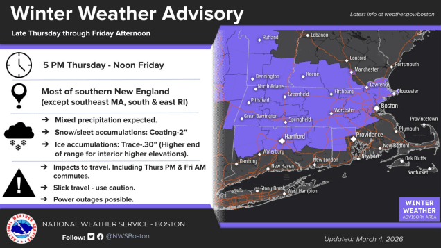
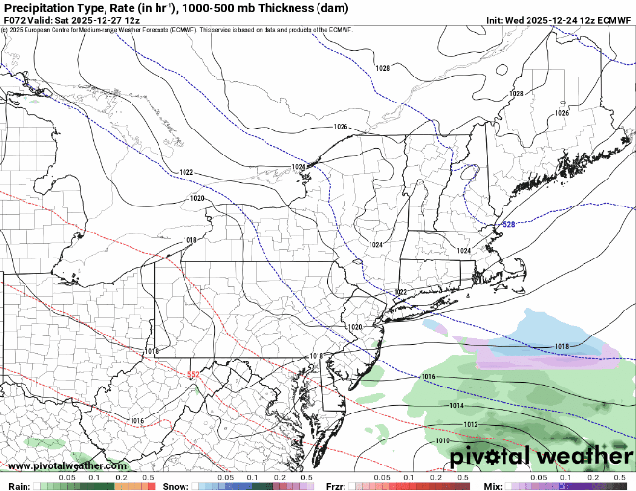
A frontal system is stalled out south of the region as high pressure in Atlantic Canada sends cold weather our way once again. Meanwhile, low pressure moving across the Midwest is sending some rain our way through the afternoon. As the colder air continues to filter in this evening, first at the surface, and then aloft, we’ll see rain changing to sleet, and possibly some freezing rain, mainly north of the Mass Pike, with mostly rain to the south. The best chance for freezing rain will be across the hills in Worcester County up into the Monadnocks of southwestern New Hampshire. As the colder air moves in aloft, a change to snow is expected, with rain changing to sleet south of Boston, though areas near the South Coast will likely stay mostly rain. Precipitation winds down Friday morning as the wave of low pressure pulls away. We’re looking at 2-4 inches of snow and sleet across southern New Hampshire and northern Massachusetts, mainly north of Route 2, with a coating to 2 inches south of there. Friday afternoon and evening will be cloudy, chilly, and damp, with some drizzle or freezing drizzle at times.
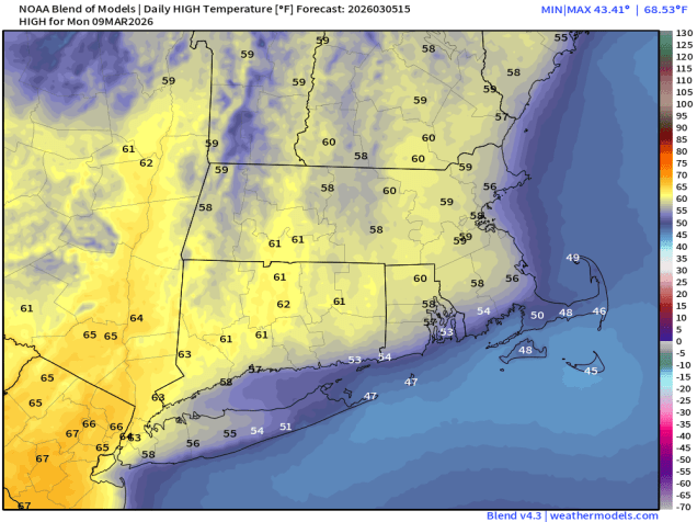
Saturday will be the start of the transition to milder weather. A stronger low pressure system will head into the Great Lakes, with southwest winds developing ahead of it. The clouds will hang tough for much of the day, though there could be a few sunny breaks, but temperatures will turn milder, likely topping 50 in many areas, though areas near the South Coast will stay in the 40s, as a southwest wind will be blowing off of the still-chilly Atlantic. A warm front moves through Saturday night, accompanied by a few rain showers, but it will keep temperatures mild through the night, likely staying in the 40s or even 50s during the overnight hours, helping to melt the snow we still have on the ground. A cold front moves through Sunday morning, possibly with another shower or two, but we’ll clear out behind it, with temperatures remaining mild, well into the 50s inland, 40s near the South Coast. High pressure then builds in for Monday with sunshine and mild temperatures, possibly reaching 60 in a few spots.
Thursday night: Cloudy with rain likely, changing to sleet/freezing rain north of the Mass Pike, and eventually snow north of Route 2. Low 27-34.
Friday: Snow, sleet, freezing rain, and rain ending during the morning, cloudy with some drizzle or freezing drizzle and fog through the afternoon, breezy at times. Snow and sleet totals 2-4 inches north of Route 2, a coating to 2 inches south of Route 2, little to no accumulation across southeastern Massachusetts and southern Rhode Island. High 32-39.
Friday night: Plenty of clouds, some drizzle or freezing drizzle likely along with more fog. Low 29-36.
Saturday: Clouds and a few sunny breaks. High 43-50.
Saturday night: Mostly cloudy with a few showers, becoming breezy. Low 38-45 in the evening, temperatures rise overnight.
Sunday: Morning clouds and fog, possibly a shower, then becoming partly to mostly sunny in the afternoon. High 50-57, cooler across Cape Cod.
Sunday night: Clear skies. Low 31-38.
Monday: Sunshine and a few clouds. High 55-62, cooler across the South Coast and Cape Cod.