A good portion of the upcoming weekend should feature some very nice mid-summer weather. Meanwhile, Tropical Storm Erin continues to gather strength in the central Atlantic.
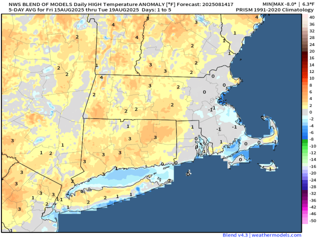
A cold front will slide offshore this evening, taking any remaining shower and thunderstorm activity with it. Behind it, high pressure builds in with sunshine, cooler temperatures and lower humidity for Friday. As the high moves off to the east, temperatures will start to creep back up on Saturday, but will be pretty close to where they should be in mid-August. Sunday looks to be another hot and humid day, though it won’t be anywhere near as oppressive as some days we had earlier in the summer. A cold front will be approaching the region though, and it may produce some showers and thunderstorms late in the day and into the evening. High pressure then builds back in with much cooler and drier air for Monday.

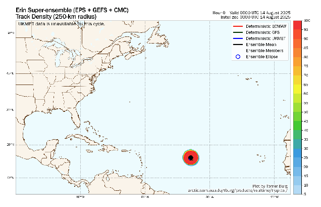
Out in the central Atlantic Ocean, Tropical Storm Erin continues to slowly get its act together. As of 11am Thursday, Erin was centered about 890 miles east of the Northern Leeward Islands, moving toward the west at 17 mph. Maximum sustained winds were near 60 mph. Conditions are becoming more favorable for Erin to intensify, as wind shear is limited at this time, the atmosphere ahead of Erin is more moist, and sea surface temperatures gradually increase as you head westward. Erin is expected to become a hurricane on Friday. As for the track, that’s fairly simple for now. A large ridge of high pressure remains in place to the north, so Erin should continue in a general west to west-northwest direction for the next few days, likely passing north of the Caribbean this weekend. It may be close enough that some of the outer bands from the storm will bring squally conditions to parts of the Virgin Islands and Puerto Rico, but a direct hit is unlikely at this time. Erin should continue to intensify this weekend, likely become a major hurricane.
Beyond this weekend, things become a little less clear. Erin will encounter a weakness in the ridge to the north, which should allow the storm to turn more toward the northwest and then north. However, when that turn occurs and how quickly it will make the turn are still very uncertain. Most of the models show the storm passing in between Bermuda and the East Coast, eventually turning northeastern and heading out into the Atlantic, but that is far from a lock at this point. The earlier the turn happens, the bigger the threat to Bermuda. The later the turn happens, the more likely that the storm could impact parts of the Bahamas. The storm will produce rough surf and increase the chances for riptides along the East Coast next week, but for now at least, that looks to be the only impact from the storm. That could change if the turn happens later, but we’ll worry about that if it happens.
There’s also a system we’re keeping an eye on in the Bay of Campeche. A cluster of thunderstorms has been slowing organizing over the past day or so, and as it heads northwestward, conditions are favorable for some development over the next day or so. The system doesn’t have a lot of time, as it will likely move inland somewhere close to the Texas/Mexico border late Friday or Friday night, but it could become a Tropical Depression or Tropical Storm before moving inland. Whether it develops of not, heavy rain, gusty winds, and coastal flooding are possible in this region for the next few days.

Thursday night: Any lingering showers or thunderstorms end in the evening, becoming clear to partly cloudy overnight. Low 62-69.
Friday: Partly to mostly sunny, not as humid. High 76-83, coolest along the coast.
Friday night: Partly cloudy, some patchy fog may develop. Low 57-64.
Saturday: Sunshine and a few clouds. High 81-88, cooler near the coast.
Saturday night: Clear to partly cloudy. Low 62-69.
Sunday: Morning sun, then increasing clouds, chance for a late-day shower or thunderstorm, humid. High 85-92, a little cooler across the South Coast and Cape Cod.
Sunday night: Any showers or thunderstorms end in the evening, becoming partly cloudy overnight. Low 59-66.
Monday: A mix of sun and clouds, cooler and less humid. High 72-79.
