Weekend Outlook: November 15-18, 2024

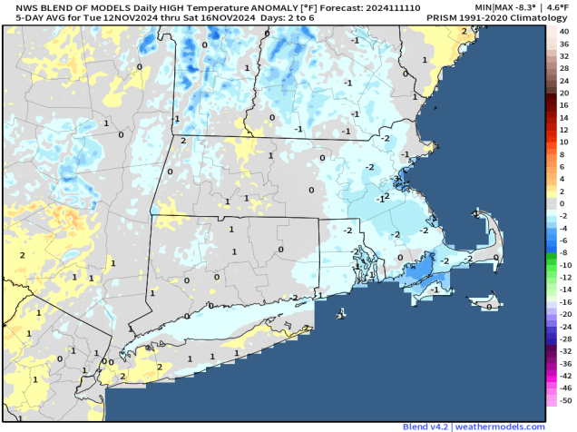
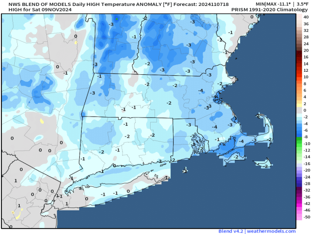
After a few chilly days, a warmup is in store for the weekend.

Temperatures will be above normal again this weekend. Image provided by Weathermodels.com

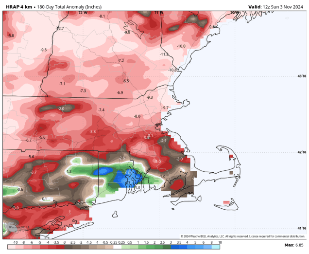
High pressure will keep us dry for the next few days, but that doesn’t mean it’s a simple forecast. A weak system passing well to our south and west tonight will spread some high clouds in, which will be just enough to keep us from getting as cold as last night. As that system pulls away on Friday, a bigger storm moving into Atlantic Canada will start to drift westward, sending more clouds our way during the afternoon, and these will be a little thicker, especially along the coast. However, we’ll also start to warm up as the airmass begins to moderate. The clouds start to move out on Saturday as upper-level high pressure builds in, with developing sunshine and milder temperatures. On Sunday, we flip things around with sunshine in the morning, then clouds start to move back in during the afternoon as a weak disturbance approaches from the west. It may produce a few widely scattered showers as it moves through on Monday, but this is far from the drought-buster that we desperately need.

The drought continues to worsen across the region. Image provided by the National Drought Mitigation Center.

Thursday night: Partly cloudy. Low 24-31, a little milder across Cape Cod.

Friday: Becoming sunny in the morning, clouds start to move back in by late in the day. High 49-56.

Friday night: Partly cloudy. Low 35-42.

Saturday: Morning clouds, especially near the coast, then becoming sunny again, breezy. High 54-61.

Saturday night: Clear skies. Low 36-43.

Sunday: Sunny through the morning, clouds start to move back in during the afternoon. High 54-61.

Sunday night: Becoming mostly cloudy. Low 36-43.

Monday: Morning clouds, possibly a shower, some afternoon clearing. High 56-63.

Weekly Outlook: November 11-17, 2024

Although today will be mild, much of this week will be cooler than we have been for a while.

Today will be the warmest day of the week by a large margin. Image provided by WeatherBell.

A warm front moved through overnight, setting us up for a mild day today, with some spots possibly making a run at 70 degrees. Any lingering showers will end this morning as a cold front moves through, with rapid clearing behind the front this afternoon. However, the airmass behind the front isn’t that cold, which is one reason why we’ll be some warm today. A second cold front moves through late tonight or early Tuesday with little moisture accompanying it. Behind it, gusty northwest winds will usher some cooler air in during the day. As high pressure moves right overhead on Wednesday we’ll have sunshine but temperatures will be quite cool, even below normal for mid-November. That high pressure area will settle into eastern Canada for the end of the week, keeping us dry and cool. A weak low pressure system moving out of the Great Lakes will spread some clouds in on Thursday, but it looks like that system will slide off to our south, so we’re not expecting any rainfall from it.

Temperatures will be a little below normal for much of this week. Image provided by Weathermodels.com.

The end of the week and the weekend becomes a little more complicated, but the end result is that we should remain dry and seasonably cool. We’ll have an ocean storm moving into Atlantic Canada that is going to try and back in from the east, and a big high pressure centered to our west. The high should win out, keeping us dry and seasonably cool, but there may be clouds and a few showers at times, and possibly some gusty winds, especially near the coast, thanks to the ocean storm. We’ll keep a close eye on how this actually evolves later this week, and will update things in our Weekend Outlook on Thursday.

The weekend forecast is a battle between low pressure to our east and high pressure to our west. Images provided by Pivotal Weather.

Monday: Showers ending early, then skies become mostly sunny in the afternoon, breezy. High 61-68.

Monday night: Clear to partly cloudy, becoming breezy again late at night. Low 40-47.

Tuesday: Sunshine and a few clouds, breezy, cooler. High 48-55.

Tuesday night: Partly cloudy across Cape Cod and the Islands, clear elsewhere. Low 25-32, a little milder across Cape Cod and the Islands.

Wednesday: Plenty of sunshine with a few clouds across Cape Cod and the Islands, chilly. High 41-48.

Thursday: Intervals of clouds and sun. High 41-48.

Friday: Partly sunny, clouds may become a little more prevalent late in the day with just a slight chance for a few showers, especially near the coast. High 46-53.

Saturday: A mix of sun and clouds, breezy. High 49-56.

Sunday: Partly sunny. High 52-59.

Weekend Outlook: November 8-11, 2024

Unseasonably warm weather is on the way out, but could there be some much-needed rain on the way?

Temperatures will be a little below normal around here on Saturday. Image provided by Weathermodels.com

A cold front crossed the region earlier, bringing an end to the record warmth we had yesterday, but we’re still enjoying another mild day today with high pressure building in. Tomorrow looks to be another mild day, but another cold front is on its way. This one moves through late in the day with just some clouds and little to no rainfall, but even cooler air settles in behind this front. High pressure builds in for Saturday with temperatures that are closer to where we should be in early November, maybe even a little below normal, despite lots of sunshine. Clouds come streaming back in on Sunday as low pressure heads into the Great Lakes, sending a warm front our way. This front may produce some showers Sunday evening and night as it moves through. We’re not expecting a lot of rainfall with these showers, but as the drought continues to worsen and fire danger remains high, we need every drop we can get. Behind the front, milder air moves in for Monday, but it will be short-lived as the cold front moves through in the afternoon, with skies starting to clear out behind it by late in the day.

It’s not a drought-buster, but the models all agree on a little rain around here Sunday night. Images provided by Pivotal Weather.

Thursday night: Clear skies. Low 38-45.

Friday: Sunshine and a few afternoon clouds, breezy. High 57-64.

Friday night: Evening clouds, then becoming clear, breezy. Low 33-40.

Saturday: Plenty of sunshine, breezy, and cooler. High 46-53.

Saturday night: Clear skies, some clouds may start to filter in toward daybreak. Low 27-34.

Sunday: Increasing and thickening clouds, showers may develop may evening. High 52-59.

Sunday night: Cloudy with showers likely. Low 43-50 during the evening, temperatures may rise a little overnight.

Monday: Showers end early, some clearing in the afternoon. High 58-65.

Weekly Outlook: November 4-10, 2024

Little rainfall is expected this week, which means drought conditions will continue to worsen across the region.

Rainfall has been above normal across parts of Rhode Island over the past 6 months, but below to well below normal for the rest of the region. Image provided by WeatherBell.

High pressure slides offshore today and a warm front heads toward the region. Clouds will increase and thicken up during the day ahead of the front, but only a few widely scattered showers will accompany the front tonight. Temperatures will rise tonight behind the front, with a couple of unseasonably warm days likely once again for Tuesday and Wednesday, with temperatures topping 70 in many areas , especially on Wednesday. A cold front will cross the region Wednesday night, accompanied by little to no rainfall once again. High pressure builds in for Thursday and Friday with cooler conditions, though temperatures will remain above normal for early November. Another cold front moves through Friday night with little fanfare, but even cooler weather follows for the weekend as high pressure builds back in. Clouds will start to move back in by late Sunday ahead of yet another system that will move in for the start of next week.

Record highs are possible across the Northeast on Wednesday. Image provided by Weathermodels.com

Monday: Sunshine filtered through high clouds, but they’ll thicken up late in the day. High 49-56.

Monday night: Mostly cloudy, slight chance for a shower. Low 43-50 in the evening, temperatures start to rise overnight.

Tuesday: Morning clouds, becoming partly sunny, breezy, and warmer. High 64-71.

Tuesday night: Clear to partly cloudy, breezy. Low 55-62.

Wednesday: A mix of sun and clouds, breezy, slight chance for a shower at night. High 69-76, a little cooler across Cape Cod.

Thursday: Mostly sunny, not as warm. High 59-66.

Friday: Sunshine and a few clouds, breezy. High 56-63.

Saturday: Mostly sunny and cooler. High 50-57.

Sunday: Morning sunshine fades behind increasing afternoon clouds, showers possible at night. High 52-59.

Weekend Outlook: November 1-4, 2024

There’s not much rain in the forecast, and that’s not good for the worsening drought.

Little rainfall is on the way to help with the drought. Image provided by the National Drought Mitigation Center.

Unseasonably warm weather continues across the region into Friday ahead of a strong cold front. We’ll see clouds start to move in tonight as the cold front gets closer, but it doesn’t have a lot of moisture to work with, so we’re only expecting a few widely scattered showers when the front moves through late Friday morning. We’ll quickly clear out behind the front in the afternoon, but the cooler air lags a bit behind the front, so we’ll have another warm day, with temperatures likely topping 70 in many areas once again. High pressure then builds in for the weekend with much cooler weather, with temperatures a little below normal for early November. Clouds will start to move back in Sunday night and Monday as another warm front heads our way. We’ll likely stay on the cool side during the day, with any showers likely holding off until evening or more likely overnight, but again, we’re not expecting drought-busting rain, just some widely scattered showers.

Average highs for early November are in the middle 50s. Image provided by weathermodels.com.

Don’t forget – Daylight Saving Time ends at 2am Sunday, so you’ll get an extra hour of sleep when we turn the clocks back one hour.

Clocks go back 1 hour at 2am on Sunday. Image provided by the Associated Press.

Thursday night: Becoming partly to mostly cloudy, slight chance for a few showers toward daybreak, winds start to pick up late at night. Low 57-64.

Friday: Cloudy and breezy with a few widely scattered showers in the morning, skies quickly clear out after midday. High 71-78, a little cooler across Cape Cod.

Friday night: Clear to partly cloudy with diminishing winds. Low 40-47.

Saturday: Mostly sunny, much cooler. High 51-58.

Saturday night: Clear skies. Low 30-37.

Sunday: Sunshine with some afternoon clouds. High 48-55.

Sunday night: Becoming mostly cloudy. Low 30-37.

Monday: Plenty of clouds, a few showers possible toward evening. High 47-54.

Weekly Outlook: October 28 – November 3, 2024

Temperatures will be riding a rollercoaster this week, but we’re still not expecting much rain.

It’s looking rather chilly across the region tonight. Image provided by WeatherBell.

The week starts off with a rather chilly day as high pressure settles in. Despite sunshine, temperatures will only get into the 50s for most spots, and some may not even get that warm. As the high moves overhead tonight, we’ll have clear skies and light winds – a perfect recipe for radiational cooling. Some high clouds may start to move in overnight, which would slow the temperature fall. Temperatures should drop below freezing for much of the region, except possibly the urban areas and some spots across Cape Cod. If you’ve still got a few plants outside, it’s time to bring them in. The high slides off to the east on Tuesday, allowing temperatures to start to moderate a bit. Clouds move in late in the day ahead of a warm front. That warm front may bring in a few showers Tuesday night, but they shouldn’t be that widespread or heavy. Behind it, much milder weather returns for Wednesday and Thursday. Despite some clouds, temperatures will likely top 70 again in many locations on Halloween, and possibly even 80, which will make for some rather nice trick-or-treating weather Thursday evening, and possibly set a few records as well. Another cold front will move in early Friday, again with only a few showers accompanying it. Temperatures look like they’ll be quite mild in the morning, but cooler air moves in behind it during the afternoon. If the front comes in even later than we’re currently thinking, then we could see many places get well into the 70s again on Friday. High pressure returns for next weekend with much cooler air once again.

The models don’t agree on the timing of Friday’s cold front, which has a significant impact on the temperature forecast. Images provided by Pivotal Weather.

Don’t forget – Daylight Saving Time ends Sunday at 2am, when the clocks go back one hour. So, the good news is that you get an extra hour of sleep Saturday night. The bad news? Sunset next Sunday is at 4:34pm.

Clocks go back one hour at 2am on Sunday. Image provided by the Associated Press.

Monday: Sunshine and a few clouds. High 48-55.

Monday night: Clear through the evening, some high clouds may start to drift in after midnight. Low 27-34, a little milder across the Outer Cape and in urban areas.

Tuesday: Increasing and thickening clouds. High 52-59.

Tuesday night: Mostly cloudy, chance for some widely scattered showers. Low 46-53 during the evening, temperatures may start to rise a bit after midnight.

Wednesday: Becoming partly sunny, breezy, and warmer. High 67-74, a little cooler across Cape Cod.

Thursday: Partly sunny, breezy, and very warm. High 72-79, a little cooler across Cape Cod.

Friday: Some morning showers, some clearing in the afternoon, breezy. High 63-70.

Saturday: Mostly sunny, cooler. High 49-56.

Sunday: Sunny in the morning, clouds start to move back in during the afternoon. High 53-60.

Weekend Outlook: October 25-28, 2024

As we head into the final weekend of October, temperatures will return to near to below normal.

Average high temperatures for late October are in the upper 50s. Image provided by Weathermodels.com

A cold front continues to push offshore this evening and high pressure builds in with clearing skies and diminishing winds resulting in a cooler night than the past few. Friday should feature a good amount of sunshine and temperatures that are closer to where we should be in late October, but another cold front will be approaching from the west. Clouds will start to move in late in the day ahead of the front, then it should move through on Saturday morning. As has been the case for a while now, this front will not have much moisture to work with, so aside from a few widely scattered showers, most places will remain dry when the front moves through. We’ll clear out during the day on Saturday with breezy conditions as even cooler air settles into the region. High pressure builds in for both Sunday and Monday with sunshine returning, but temperatures that will be below normal, with most places likely not reaching 60 either day, and widespread frost and freezing temperatures are expected Sunday night, except for urban locations and parts of Cape Cod and the Islands.

Drought conditions continue to expand across the Northeast. Image provided by the National Drought Mitigation Center.

Thursday night: Becoming clear with diminishing winds. Low 38-45, a little milder across Cape Cod.

Friday: Plenty of sunshine, clouds start to filter in late in the day. High 55-62.

Friday night: Becoming partly to mostly cloudy, just a slight chance for a shower. Low 41-48.

Saturday: Morning clouds, then skies clear out in the afternoon, breezy. High 59-66.

Saturday night: Clear skies. Low 34-41, a little milder across Cape Cod.

Sunday: Sunshine and a few afternoon clouds, breezy, and cooler. High 49-56.

Sunday night: Clear to partly cloudy and chilly. Low 28-35, a little milder across Cape Cod.

Monday: Lots of sunshine, chilly. High 47-54.

Weekly Outlook: October 21-27, 2024

Our stretch of dry and warm weather will continue for a few more days, but changes are coming later this week.

Another fantastic mid-Autumn day is expected today. Image provided by WeatherBell.

We start the week off with high pressure still in control, giving us dry and unseasonably warm conditions through Wednesday. High temperatures will likely top 70 in many areas each of the next 3 days, and a few places could even reach 80 this afternoon, though a backdoor cold front may bring some cooler weather into coastal areas on Tuesday. However, all good things must come to an end, and a stronger cold front will bring an end to the warm weather on Thursday. Breezy and cooler weather is likely with the frontal passage early in the day, but as has been the case for a while now, little rainfall will accompany it. After a couple of cool and dry days, another cold front will approach on Saturday. Once again, we’re not expecting drought-busting rainfall with this front, just a few widely scattered showers. Behind that front even cooler weather settles in for the end of the weekend.

Precipitation has been below normal over the past 6 months and this week won’t help that. Image provided by the Northeast Regional Climate Center.

Monday: Sunshine with just a few afternoon clouds. High 72-79, a little cooler across Cape Cod.

Monday night: Clear to partly cloudy. Low 49-56.

Tuesday: Plenty of sunshine. High 69-76, a littler cooler along the coast.

Tuesday night: Clear to partly cloudy. Low 49-56.

Wednesday: Mostly sunny. High 69-76, a little cooler across Cape Cod.

Thursday: Some morning clouds, then becoming mostly sunny, breezy, and much cooler. High 56-63.

Friday: Mostly sunny. High 52-59.

Saturday: Partly sunny, chance for a few widely-scattered showers. High 56-63.

Sunday: Partly to mostly sunny, breezy, and cool. High 50-57.

Weekend Outlook: October 18 – 21, 2024

A warmup is on the way for the weekend.

Temperatures could get well into the 70s on Monday. Image provided by WeatherBell.

For the most part, we’ve got a rather simple forecast for the next several days. An area of low pressure well south of New England will keep clouds in place across southeastern Massachusetts into Friday with some gusty northeast winds at times. Otherwise, high pressure will slide across the region and off to the east over the next several days, resulting in sunny days and clear night. Temperatures will warm back up to above normal levels over the weekend, with many places likely reaching or exceeding 70 as winds become more south to southwesterly. This pattern will likely continue into a good portion of next week as well.

Some models have no rain at all here through next weekend. Image provided by Weathermodels.com

Thursday night: Slow clearing across Southeastern Massachusetts and Cape Cod, clear skies elsewhere, breezy along the coast and across Cape Cod. Low 34-41, a little milder near the coast and urban areas.

Friday: Plenty of sunshine, a few clouds across Cape Cod, winds gradually subside. High 56-63, coolest along the coast.

Friday night: Clear skies. Low 36-43.

Saturday: Lots of sunshine. High 63-70, coolest across Cape Cod.

Saturday night: Clear. Low 38-45.

Sunday: Sunshine and a few clouds. High 66-73, coolest across Cape Cod.

Sunday night: Clear skies. Low 45-52.

Monday: More sunshine. High 70-77, coolest across Cape Cod.

Weekly Outlook: October 14-20, 2024

This week will be the coolest week we’ve had around here in the past six months.

Temperatures will be below normal for much of the upcoming week. Image provided by Weathermodels.com

We’re starting the week off on a damp note with a low pressure system crossing the region, generating a few more showers, mainly during the morning hours today. We’ll start to clear out behind a cold front this afternoon, with gusty northwest winds developing. We may turn mild this afternoon, with parts of the region topping 60, especially south of Boston, but much cooler air will settle in behind the front tonight. High pressure builds in with dry and cool conditions for Tuesday into Thursday, but with an upper-level low moving across the Northeast, it will remain breezy, with a few clouds around at times. In addition, the onshore flow around the high pressure area may bring a few clouds and even a shower or two into coastal areas. To our north, this upper-level low will generate some snow showers across parts of Northern New England, especially in the mountains, but that’s not a concern around here. As the high slides off to the east, temperatures should start to moderate at the end of the week. Another frontal system may move in for the end of the weekend, but for now, it doesn’t look like it will have much moisture to work with.

It’s getting toward that time of year. Some snow is likely in the mountains this week. Image provided by WeatherBell.

Monday: Cloudy and becoming breezy with showers ending by early afternoon, skies start to clear out late in the day. High 52-59 north of the Mass Pike, 60-67 south of the Pike.

Monday night: Clear to partly cloudy. Low 34-41.

Tuesday: Sunshine with some afternoon clouds, breezy, and cooler, slight chance for an afternoon shower near the coast. High 49-56.

Tuesday night: Clear to partly cloudy. Low 34-41.

Wednesday: A mix of sun and clouds, slight chance for a shower along the coast. High 48-55.

Thursday: Partly to mostly sunny, another shower possible near the coastline. High 52-59.

Friday: Plenty of sunshine, milder. High 59-66.

Saturday: More sunshine. High 62-69.

Sunday: Partly to mostly sunny. High 64-71.