Some snow is on the way, quite a bit for some areas, and probably more than once this week.
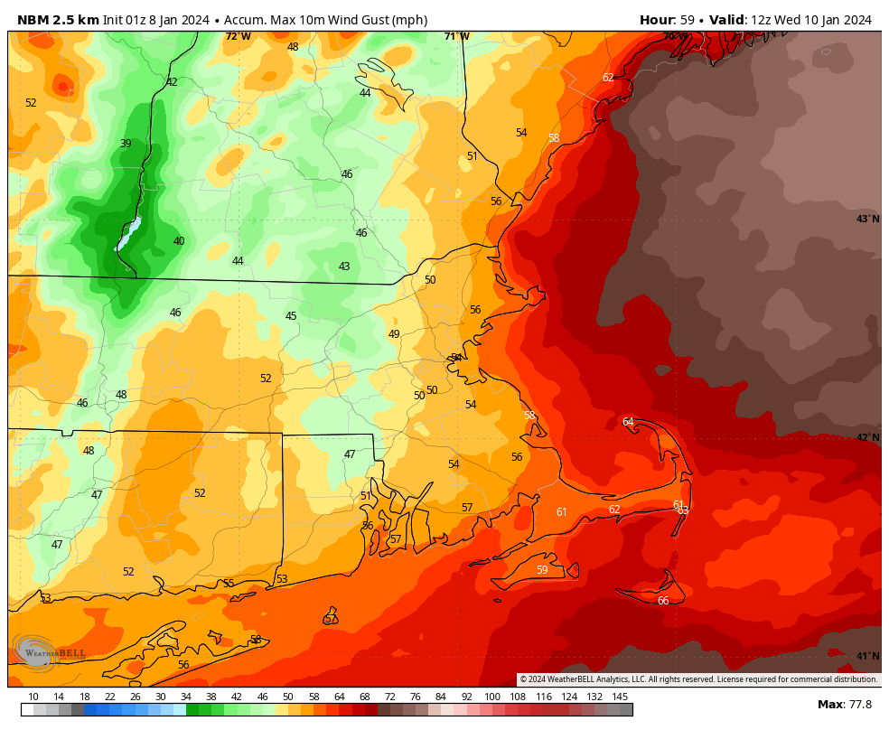
We’ll start the week off with sunshine thanks to high pressure in control of the region, but it won’t last too long. Clouds will start to steam in this afternoon and thicken up tonight as the low pressure area that brought severe weather to parts of Texas and the Deep South yesterday moves into the Tennessee Valley. By Monday night, a secondary area of low pressure will develop near the Mid-Atlantic coast, passing south of New England on Tuesday. There’s not a lot of cold air in place, but with the storm passing far enough to the south, we should be cold enough for snow across most of the region, except for parts of Cape Cod and possibly southeastern Massachusetts, but even there, a change to snow is expected. The snow will be accompanied by gusty northeast winds, especially across the Cape and Islands where a High Wind Watch has been posted. With tides already at astronomically high levels, some coastal flooding is also expected, so a Coastal Flood Watch has been issued for much of eastern Massachusetts. The storm will be moving rather quickly, so snowfall totals won’t be outrageous. Snow should start around sunrise Tuesday, and end around sunset, but in between, it could snow rather heavily for a while late Tuesday morning and early afternoon. If you don’t have to be on the roads, we’d recommend you stay home. Complicating the snow forecast is that many of the models show a sharp cutoff to the northern edge of the snow, but don’t agree where that northern edge will be. Some have it in central New Hampshire, some in southern New Hampshire, some across northern Massachusetts. Wherever it does setup, you are going to see snowfall totals go from quite a bit to virtually nothing over a small area, perhaps even as little as 20 miles. Having said that, our snowfall forecast is, for lack of a better term, our “best guess” across central and southern New Hampshire right now.

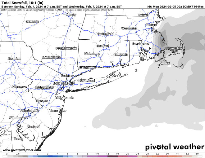
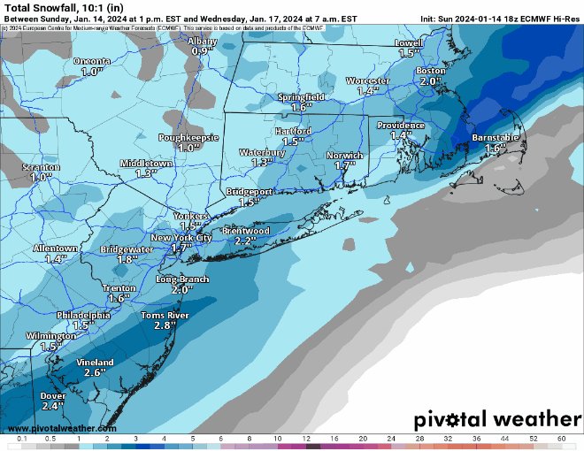
So, how much snow can we expect?
Outer Cape/Islands: 1-3″
Upper Cape/South Coast: 3-5″
Central New Hampshire: (Concord): 3-6″
Southeastern Massachusetts: 4-8″
Southern New Hampshire (Nashua/Manchester to Portsmouth): 4-8″
Remainder of Eastern Massachusetts: 6-10″ with a few spots picking up 12″ or more
We’ll quickly clear out Tuesday night, then a cold front moves through with a few flurries Wednesday morning, followed by high pressure building in for Wednesday afternoon and Thursday with sunshine and colder weather. Clouds will start to move back in later Thursday ahead of a weak storm system moving out of the Great Lakes. That system will bring in some light snow or rain for Thursday night into early Friday. Skies will start to clear out Friday afternoon, but clouds quickly return ahead of yet another storm moving out of the Ohio Valley. This one will likely bring in some more light snow on Saturday. Another cold front follows on Sunday with some more clouds and possibly a few snow showers.

Monday: Morning sunshine, clouds filter in and thicken up during the afternoon. High 42-49.
Monday night: Becoming mostly cloudy, snow developing by daybreak, possibly mixed with some rain across Cape Cod and southeastern Massachusetts. Low 26-33.
Tuesday: Windy with snow, possibly heavy at times, tapering off late in the day. High 30-37 early, temperatures start falling in the afternoon.
Tuesday night: Any lingering snow ends in the evening, then skies clear out, breezy. Low 17-24.
Wednesday: Sunshine and a few clouds, windy, colder, slight chance for a snow flurry early. High 28-35.
Thursday: Sunny in the morning, clouds move in during the afternoon, some light snow or rain possible overnight, breezy. High 31-38.
Friday: Any snow or rain ends early, becoming partly sunny and windy in the afternoon. High 33-40.
Saturday: Mostly cloudy and breezy with some light snow possible. High 28-35.
Sunday: Partly sunny, breezy, chance for a few snow showers. High 31-38.