Weekend Outlook: June 14-17, 2024

The weekend is going to start off unsettled, but the rest of it looks terrific.

Strong to severe thunderstorms are expected on Friday, especially north and west of Boston. Image provided by the Storm Prediction Center.

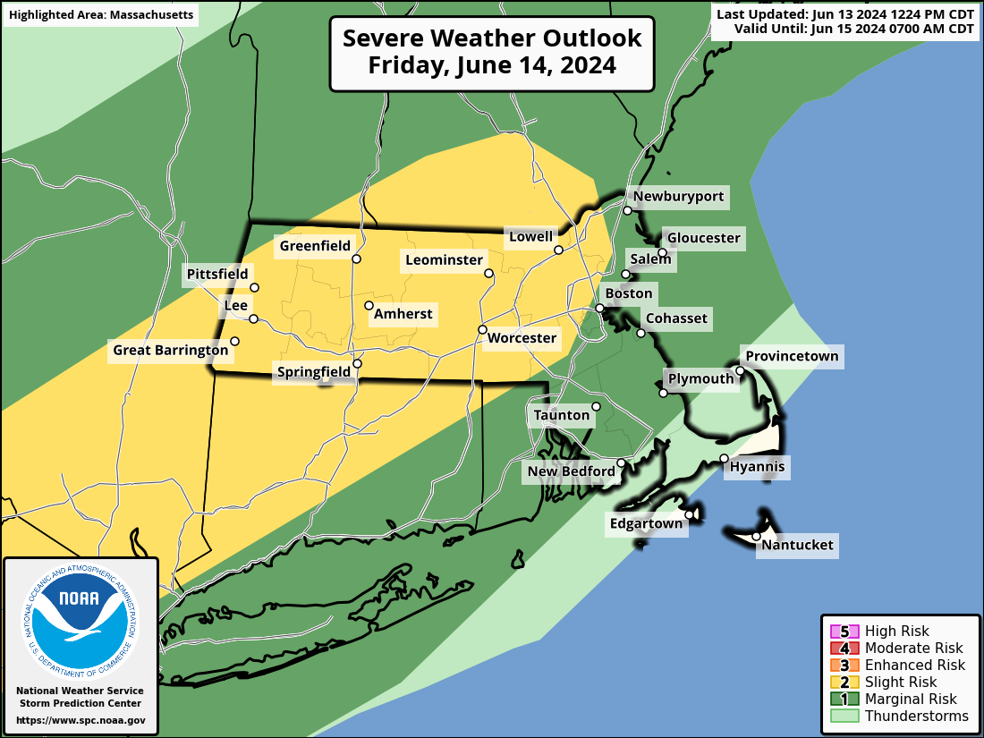
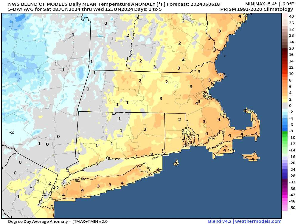
High pressure will slide offshore tonight and Friday, with southwest winds bringing warm and increasingly humid air into the region. A cold front will approach from the west during the day on Friday. A line of showers and thunderstorms will develop ahead the front. Conditions should be ripe for some of these storms to become strong to severe during the afternoon and evening, especially north and west of Boston. Some of the storms produce hail and strong winds, with heavy downpours also likely. As the storms move into the Boston area and southeastern Massachusetts they should start to weaken, but some gusty winds and heavy downpours are still possible. The front moves offshore at night, bringing an end to the showers and storms, though they may not end completely until close to daybreak across parts of the Cape and possibly southeastern Massachusetts. High pressure then builds back in for Saturday and Sunday with cooler and drier air. By Monday, the high will move off to the east and warmer and more humid air will start to move back in. This will be the beginning of what looks like a hot week , but we’ll get into more details on that in our Weekly Outlook Sunday night.

The latter half of next week is looking hot around here. Image provided by Weathermodels.com

Thursday night: Clear skies, some clouds may start to drift in late at night. Low 60-67.

Friday: Morning sun, then clouds move in with shower and thunderstorms developing in the afternoon, some could be strong to severe, becoming breezy in the afternoon. High 80-87, little cooler across Cape Cod.

Friday night: Mostly cloudy with showers and thunderstorms ending from northwest to southeast. Low 57-64.

Saturday: Becoming mostly sunny and less humid. High 71-78, coolest near the coast.

Saturday night: Clear skies. Low 48-55.

Sunday: Sunshine and some afternoon clouds. High 72-79, a little cooler at the coast with afternoon seabreezes.

Sunday night: Partly cloudy. Low 53-60.

Monday: A mix of sun and clouds. High 77-84, a little cooler across the South Coast and Cape Cod.

Weekend Outlook: June 7-10, 2024

If you’re looking for perfect summer weather this weekend, you’ll be disappointed, but it won’t be as bad as your weather app is showing.

Overall, temperatures will be a little above normal over the next few days. Image provided by Weathermodels.com

A cold front will move in from the west this evening, bringing with it another round of showers and perhaps some thunderstorms as well. Beyond that, an upper-level low will drift in from the Great Lakes and sit across the Northeast through the weekend. That will keep us cooler than recent days and unsettled as well. We’re not expecting any of the days to be a washout this weekend, but what you can expect is plenty of clouds (with some sunny breaks), and daily episodes of showers, perhaps a few thunderstorms, as impulses of energy rotate around that upper low.

Some models show the potential for a few downpours over the next few days, but for the most part, precipitation totals should be on the lighter side. Images provided by Pivotal Weather.

Thursday night: A few showers possible this evening, followed by some late night clearing. Low 57-64.

Friday: A sunny start to the day, then clouds move back in during the afternoon, just a slight chance for a shower. High 77-84.

Friday night: Clear to partly cloudy. Low 53-60.

Saturday: Partly sunny, breezy, slight chance for a shower. High 71-78.

Saturday night: Partly cloudy, chance for some showers. Low 53-60.

Sunday: Intervals of clouds and sunshine, chance for a few showers, mainly in the morning. High 70-77.

Sunday night: Partly cloudy, chance for a shower or two. Low 52-59.

Monday: A mix of sun and clouds, slight chance for a shower. High 69-76.

Weekend Outlook: May 31-June 3, 2024

The first weekend of June should feature some fantastic weather for our area.

It’ll be on the chilly side if you’re heading out early Friday morning. Image provided by WeatherBell.

Low pressure pulls away from the region this evening, taking the last of the showers with it, then skies clear out, resulting in a chilly night, with temperatures dropping into the 40s in many areas. High pressure builds in for Friday with sunshine and temperatures turning milder, but still near or a little below normal for the final day of May. We’ll warm up more on Saturday as the high moves off to the East. A weak system will try to move in on Sunday, bringing us some clouds, but it looks like any rain with it should stay off to our south and west. Sunshine returns on Monday, with just a few pop-up showers or thunderstorms possible in the afternoon, mainly across the interior.

Most of the models keep any rain south and west of our area on Sunday. Images provided by Pivotal Weather.

Thursday night: Any lingering showers end this evening, then skies clear out. Low 44-51.

Friday: Sunshine and some afternoon clouds. High 68-75, coolest along the coast.

Friday night: Clear skies. Low 47-54.

Saturday: Plenty of sunshine. High 74-81, a little cooler near the coast.

Saturday night: Partly cloudy. Low 50-57.

Sunday: Partly sunny, just a slight chance for a late-day shower. High 75-82, a little cooler near the coast.

Sunday night: Partly cloudy. Low 53-60.

Monday: Partly to mostly sunny, a pop-up shower or thunderstorm is possible in the afternoon. High 76-83, a little cooler near the coast.

Weekend Outlook: May 24-27, 2024

Most of the Memorial Day Weekend should feature some fantastic weather, but not all of it.

Temperatures will remain above normal for the next several days. Image provided by WeatherBell.

A cold front will move across the region this evening, possibly producing one more round of showers and thunderstorms, a few of which could be strong across the interior, then we’ll start to dry out overnight as the front pushes offshore and then stalls out. High pressure builds in for Friday and Saturday with sunshine, warm temperatures, and lower humidity. A weak system will move through Saturday night with some clouds, and possibly a few showers, but it shouldn’t cause any issues. Sunday should be another great day, though a pop-up shower or thunderstorm is possible in the afternoon. As for Memorial Day itself – the first half of the day should be fine for any parades or outdoor ceremonies. However, an upper-level low pressure area moving into the Great Lakes will send plenty of clouds in, with some showers developing by late afternoon as a warm front moves toward the region. So, if you’ve got any outdoor plans, be prepared to head inside at some point during the afternoon and evening.

The models differ on how quickly the rain will move in Monday afternoon. Images provided by Pivotal Weather.

Thursday night: Any showers or thunderstorms end in the evening, skies start to clear out overnight. Low 55-62.

Friday: Becoming sunny, not as humid. High 77-84, cooler across Cape Cod.

Friday night: Clear skies. Low 51-58.

Saturday: Sunshine and some afternoon clouds. High 75-82, a little cooler near the coast.

Saturday night: Partly to mostly cloudy, chance for a few showers. Low 51-58.

Sunday: Any early shower, then becoming partly sunny, slight chance for an afternoon shower or thunderstorm. High 75-82, cooler near the coast.

Sunday night: Becoming mostly cloudy. Low 52-59.

Memorial Day: Mostly cloudy, showers develop in the afternoon. High 67-74.

Weekend Outlook: May 10-13, 2024

Cool weather will remain in place for a good chunk of the weekend.

Well below normal temperatures are expected through the weekend. Image provided by WeatherBell.

A weak low pressure area will pass south of the region tonight and early Friday, generating some showers, mainly south of the Mass Pike. High pressure then builds in from the north later Friday into Saturday, with some sunshine developing, but east to northeast winds off the still-chilly Atlantic will keep temperatures below normal for mid-May, especially close to the coast. Another weak system may bring in a few more showers on Sunday before high pressure builds back in for Monday, this time with warmer weather as winds should shift into the west or southwest.

Temperatures get back closer to normal on Monday. Image provided by Weathermodels.com

Thursday night: Becoming mostly cloudy, some showers likely, mainly south of the Mass Pike. Low 41-48.

Friday: Showers end early, some afternoon sunshine develops, breezy. High 52-59, coolest along the coast.

Friday night: Partly cloudy. Low 38-45.

Saturday: Intervals of clouds and sun. High 51-58, coolest along the coast.

Saturday night: Mostly cloudy. Low 38-45.

Sunday: Plenty of clouds, chance for a shower or two, some late-day clearing possible. High 51-58, coolest along the coast.

Sunday night: Becoming partly cloudy. Low 39-46.

Monday: Partly sunny. High 60-67, coolest along the coast.

Weekend Outlook: May 3-6, 2024

Cooler weather is expected for the next few days with some rain expected this weekend.

Average high temperatures for early May are in the lower to middle 60s. Image provided by Weathermodels.com

Low pressure sends a few showers across the region this evening, then cooler weather settles in behind in for Friday into Saturday. We’ll remain dry both days, but clouds will be prevalent, mainly due to the onshore flow on Friday and ahead of low pressure moving in from the west on Saturday. That low pressure area will bring in a period of rain on Sunday, keeping us rather cool once again. High pressure builds in for Monday with sunshine and warmer temperatures returning.

Monday afternoon will be 10-20 degrees warmer than Sunday afternoon across the region. Image provided by WeatherBell.

Thursday night: Mostly cloudy, any showers end during the evening. Low 41-48.

Friday: Clouds and some afternoon sunshine. High 54-61 a little cooler near the coast.

Friday night: Partly to mostly cloudy. Low 40-47.

Saturday: More clouds than sunshine. High 56-63, a little cooler near the coast.

Saturday night: Mostly cloudy. Low 40-47.

Sunday: Cloudy with rain likely. High 52-59.

Sunday night: Mostly cloudy with showers ending. Low 43-50.

Monday: A mix of sun and clouds. High 69-76, cooler right along the coast.

Weekend Outlook: April 26-29, 2024

Some nicer weather is on the way for the weekend, but the forecast isn’t quite that simple.

Freeze Warnings are in effect for parts of the region tonight. Image provided by Pivotal Weather.

High pressure remains in control into Saturday with sunshine and cool conditions. Freeze Warnings are in effect again tonight south of the Mass Pike and along the coast. If you’re wondering why there are no Freeze Warnings north and west of Boston, it’s not because it won’t be as cold, it’s because we haven’t received the average date of the last 32-degree reading for the year yet in those areas. Temperatures will gradually moderate on Friday and Saturday as the high slides off to the east. By later Saturday we’ll see some high clouds start to move in ahead of a warm front. They’ll thicken up in the evening with a few showers likely Saturday night. By Sunday, we’ll turn a bit milder, but we’ll still have plenty of clouds around and a pop-up shower is possible. Monday is the day with the trickiest forecast. We’ll be mostly dry, with partly sunny skies, and just a slight chance for a stray shower, but the temperatures forecast is not that easy. While it may get quite mild inland, a backdoor cold front could result in a much cooler day near the coast, especially north of Boston. How quickly that front moves in will impact the temperature forecast, but in the afternoon, many places near the coast will likely drop into the 50s or even upper 40s while inland areas will be well into the 60s or even 70s.

Temperatures could be 20 or more degrees cooler near the coast compared to inland areas Monday afternoon. Image provided by WeatherBell.

Thursday night: Clear and chilly. Low 27-34.

Friday: Sun, sun, and more sun. High 53-60, little cooler at the coast.

Friday night: Clear skies. Low 31-38.

Saturday: Sunny in the morning, increasing and thickening clouds in the afternoon. High 59-66, little cooler right at the coast.

Saturday night: Mostly cloudy with a few showers likely, mainly after midnight. Low 38-45.

Sunday: Intervals of clouds and sun, slight chance for an afternoon shower. High 61-68, cooler along the coast.

Sunday night: Partly cloudy. Low 47-54.

Monday: Partly sunny, slight chance for a shower. High 66-73 inland, 58-65 along the coast, possibly even cooler during the afternoon.

Weekend Outlook: April 19-22, 2024

Some drier weather is on the way, but we’ve still got some rain in our future.

Average high temperatures for mid-April are close to 60 degrees. Image provided by Weathermodels.com

Rain will come to an end this evening, then high pressure builds back in for Friday with drier conditions. There may be a few sunny breaks, but for the most part, it’ll be a cloudy and milder day. A cold front moving in from the west will bring in some showers for Friday night and Saturday morning before the front moves through. We’ll gradually clear out with gusty winds behind the front during the day, then high pressure builds in for Sunday and Monday with dry and seasonably mild conditions.

This is the wettest year-to-date for many locations across the region thus far. Image provided by the Southeast Regional Climate Center.

Thursday night: Cloudy, showers ending before midnight. Low 37-44.

Friday: Clouds with some afternoon sunshine, especially south of Boston. High 53-60, coolest along the coast.

Friday night: Becoming cloudy, a few showers during the evening, becoming more widespread after midnight. Low 40-47.

Saturday: Rain ending by early afternoon, some late-day clearing, becoming breezy. High 58-65.

Saturday night: Becoming clear. Low 36-43.

Sunday: Partly to mostly sunny, breezy. High 54-61.

Sunday night: Clear to partly cloudy. Low 36-43.

Monday: Sunshine and a few clouds, breezy. High 55-62.

Weekend Outlook: April 12-15, 2024

Our last sign that winter is over arrives this weekend – Marathon Monday, and we’ll have some rather nice weather for it as well.

As far as we’re concerned, Patriots Day is the best day of the year. Image provided by the New York Times.

The weather won’t be so nice for the few days leading up to it this weekend, but that’s typical of Spring in New England. A strong low pressure system is heading for the Ohio Valley this afternoon, sending a warm front our way. Some showers will accompany that front this evening, with temperatures rising overnight behind it. We’ll also have some gusty southerly winds ushering that warmer air in. Showers will become a steadier and heavier rain overnight, which will renew flooding concerns once again for much of the region. The low pressure system will send a cold front through Friday morning. Ahead of it, there could be a line of thunderstorms developing, with some more heavy rain and gusty winds. Everything should wind down during the afternoon, with some clearing possible late in the day. However, an upper-level low will move across the Northeast on Saturday, keeping plenty of clouds and gusty winds around with a few more showers possible, especially during the morning. We’ll see some clearing for Saturday night, but clouds quickly return on Sunday as yet another weak system heads our way. This one will bring in another round of rain showers late Sunday and Sunday night, mainly south of the Mass Pike. That system pulls away late at night, and high pressure builds in for Patriots Day on Monday with sunshine, breezy conditions, and mild temperatures. Normal high temperatures for mid-April are in the middle to upper 50s, but we should be about 5-10 degrees warmer than that.

Monday is looking like a glorious day across the region. Image provided by WeatherBell.

Thursday night: Showers redevelop, becoming a steady rain after midnight, becoming windy. Low 48-55 this evening, temperatures may rise a bit after midnight.

Friday: Rain, possibly a thunderstorm, during the morning, taper off to showers and ending early afternoon with some late-day sunny breaks possible, windy. High 57-64.

Friday night: Becoming partly cloudy, breezy. Low 41-48.

Saturday: Partly to mostly cloudy, windy, chance for a few showers, mainly in the morning. High 50-57.

Saturday night: Becoming partly cloudy, breezy. Low 38-45.

Sunday: Morning sun, then clouds return, with some showers possible late in the day, breezy. High 56-63.

Sunday night: Showers likely during the evening, skies start to clear out late at night. Low 41-48.

Monday: Plenty of sunshine, breezy. High 60-67.

Weekend Outlook: April 5-8, 2024

The weekend won’t be half bad around here. Of course, that means it’ll only be half good.

Our storm system won’t be in a hurry to leave the region this weekend. Loop provided by Pivotal Weather.

The storm that brought us more heavy rain, gusty winds, and a variety of wintry conditions will pull away from the region tonight, but it won’t get that far. An upper-level low will move in, capturing the surface low pressure area. As a result, it’ll just drift around over the Gulf of Maine and eastern New England for a few more days. That’ll keep plenty of clouds around with cool temperatures and some occasional rain or snow showers into Saturday. By Sunday, the system will finally begin to move away, with gradual clearing expected, though temperatures will remain cool. For Monday, high pressure builds in with sunshine and mild temperatures – perfect for eclipse viewing in the afternoon. Taking a quick peek at Tuesday for the Red Sox home opener, it should be sunny and seasonably cool, but a seabreeze (or backdoor cold front) may keep temperatures considerably cooler than places farther inland.

Conditions should be nearly ideal for eclipse viewing Monday afternoon. Image provided by WeatherBell.

Thursday night: Plenty of clouds, a few more snow showers from the North Shore into southern New Hampshire, some clearing possible across Cape Cod, winds diminish. Low 28-35.

Friday: Mostly cloudy, chance for a few rain or snow showers, a few sunny breaks across Cape Cod and the South Coast, breezy. High 41-48.

Friday night: Partly to mostly cloudy with few snow or rain showers possible. Low 31-38.

Saturday: Mostly cloudy, breezy, chance for more snow or rain showers. High 40-47.

Saturday night: Mostly cloudy, snow or rain showers taper off. Low 30-37.

Sunday: Plenty of clouds, a few lingering snow or rain showers early, some late-day sunny breaks develop, breezy. High 41-48.

Sunday night: Becoming clear. Low 29-36.

Monday: Sunshine and some afternoon high clouds. High 55-62.