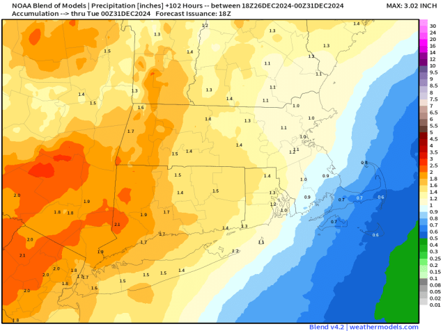
Some milder weather is on the way once again, but so is some rain.
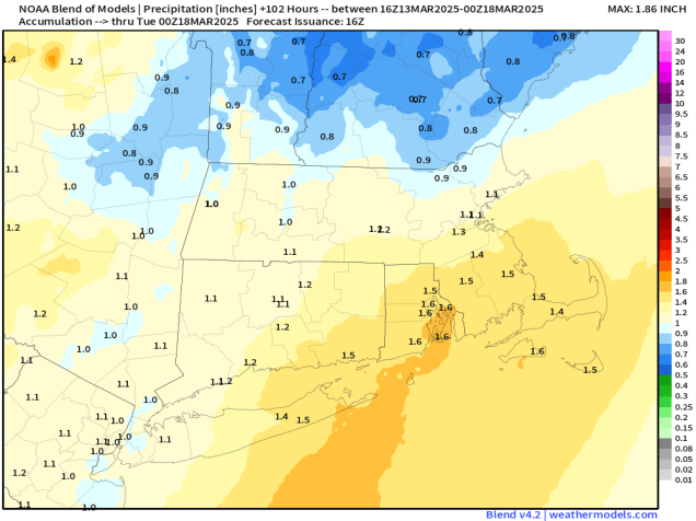
We could be looking a decent amount of rain Sunday night and early Monday. Image provided by Weathermodels.com
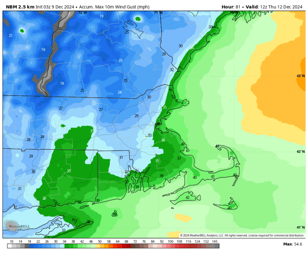
High pressure will remain in control for the next day or two, keeping us on the cool side into Friday, especially near the coast, thanks to east to northeast winds off the chilly Atlantic. We will see some sunshine developing on Friday. Skies may clear out enough tonight to allow you to view the total lunar eclipse, but that is far from a guarantee. As the high moves offshore on Saturday, winds shift into the south and southwest, bringing milder air back in, but also some clouds ahead of a storm system slowly making its way eastward. This storm will produce quite a bit of severe weather from the Mississippi and Ohio Valleys to the Gulf Coast over the next few days, but we’re not expecting that once it moves in. What we are expecting is strong southerly winds on Sunday, possibly gusting to 40-50 mph or higher. This will result in a very mild day away from the South Coast, with temperatures likely getting well into the 60s in many spots. As the cold front trailing the system draws nearer, we’ll see a few showers in the afternoon, becoming more widespread at night, some of them heavy, and some thunderstorms are possible. The front will slow down Sunday night, keeping the rain going into at least Monday morning. Once the front finally pulls away in the afternoon we may see some late-day clearing.
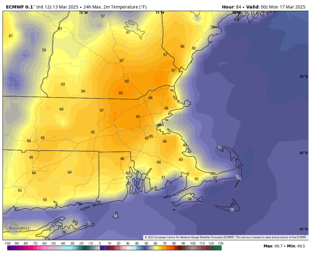
Sunday is looking like a very warm day despite plenty of clouds. Image provided by WeatherBell.
Thursday night: Partly to mostly cloudy. Low 27-34.
Friday: A mix of sun and clouds. High 48-55, a little cooler along the coast.
Friday night: Increasing clouds. Low 32-39.
Saturday: Partly sunny. High 54-61, cooler along the South Coast and Cape Cod.
Saturday night: Mostly cloudy. Low 42-49, temperatures may start to rise after midnight.
Sunday: Plenty of clouds, chance for a shower or two in the afternoon, becoming windy. High 61-68, cooler along the South Coast and Cape Cod.
Sunday night: Cloudy with periods of rain, some of it could be heavy, a thunderstorm is possible, windy at times, especially in the evening. Low 46-53.
Monday: Rain ends in the morning, some clearing late in the day. High 51-58, temperatures may start to drop in the afternoon.
It’s still astronomical winter, but March is meteorological spring. In terms of the weather, we’ll experience winter and spring at various times this week.
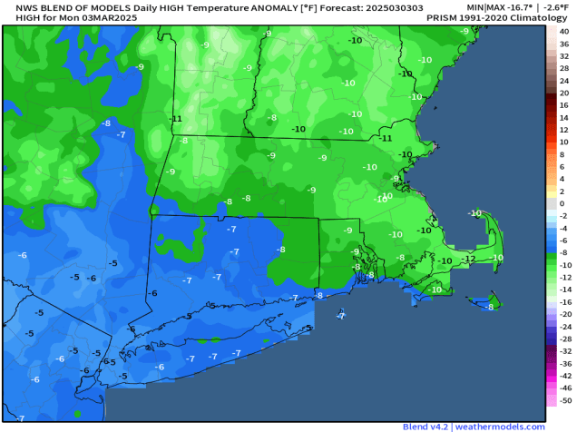
Temperatures will be about 10 degrees below normal today. Image provided by weathermodels.com
We start the week off with high pressure building in, bringing us plenty of sunshine today, but temperatures will remain quite chilly. As we head into Tuesday, the high slides offshore, and a developing low pressure system in the nation’s midsection will send a warm front our way. This will result in a milder day on Tuesday, but also more in the way of cloudcover and possibly a shower or two late in the day. That system will draw nearer on Wednesday, bringing showers in during the day, with some steadier rain at night, some of which could be heavy. We’ll also have gusty southerly winds, resulting in a very mild day, despite the clouds and rain. A cold front trailing the system will move through on early Thursday, bringing in an end to the steady rain, though a few more showers are still possible during the afternoon. An upper-level disturbance moves across the region Thursday night and early Friday with a few snow showers possible. Another weak system quickly follows on Saturday, but this one will only produce a few snow or rain showers. High pressure builds in for Sunday with dry and colder weather once again.
Temperatures should get well into the 50s on Thursday. Image provided by WeatherBell.
Monday: Plenty of sunshine. High 26-33.
Monday night: Clear during the evening, clouds start to filter in overnight. Low 14-21.
Tuesday: Partly sunny, clouds thicken up late in the day with a stray shower possible, becoming breezy in the afternoon. High 42-49.
Tuesday night: Becoming mostly cloudy. Low 33-40 during the evening, temperatures start to rise after midnight.
Wednesday: Cloudy and breezy with showers likely, steadier rain possible late in the day. High 50-57.
Wednesday night: Windy with periods of rain, tapering off late at night. Low 43-50.
Thursday: Mostly cloudy, a few more rain showers possible. High 52-59.
Thursday night: Partly to mostly cloudy, breezy, chance for a few late-night snow showers. Low 23-30.
Friday: A mix of sun and clouds, chance for a morning snow shower, windy. High 36-43.
Saturday: Intervals of clouds and sun with a few rain or snow showers possible, breezy. High 40-47.
The active pattern will continue for most of the week with a few more chances for wintry weather.
Sunday’s storm dropped 3-7 inches of snow across the region. Image provided by the National Weather Service office in Norton, MA.
We’re starting the week out with high pressure in control, giving us sunshine and chilly conditions today. Many places will get above freezing allowing for snow to melt, but as temperatures drop this evening, icy conditions will likely develop on untreated surfaces, so keep that in mind if you are heading out this evening. Clouds will start to move in on Tuesday ahead of another low pressure system. This one will bring snow into the Mid-Atlantic states, but likely passes well south of New England. However, the precipitation field surrounding the storm could get far enough north Tuesday night to bring a little light snow into the South Coast, Cape Cod, and the Islands, possibly as far north as parts of Rhode Island and southeastern Massachusetts. We’re not looking at much snow, just a dusting to perhaps an inch, so it’ll be more of a nuisance than anything else if it happens. High pressure brings drier air in for Wednesday, then things get complicated.
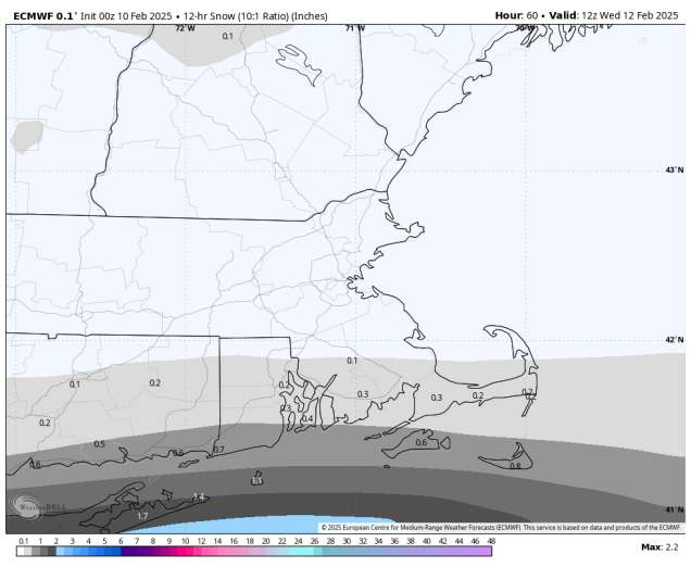
Some “nuisance snow” is expected near the South Coast Tuesday night. Image provided by WeatherBell.
Low pressure will move into the Great Lakes late Wednesday, then into the St. Lawrence Valley Wednesday night and Thursday. We’ll see snow developing ahead of the system Wednesday night, but as warmer air moves in aloft, a change to sleet and then freezing rain is likely. The question becomes – does a secondary area of low pressure develop and pass south of New England early Thursday? If it does, that will keep the cold air in place in the surface, resulting in sleet and freezing rain continuing across the interior, with a change to plain rain south of the Mass Pike. If it doesn’t, then the warmer air eventually moves in at the surface, with a change to plain rain across most of the region before the precipitation ends by midday Thursday. High pressure builds in with drier air for Friday and the first part of Saturday before things get complicated once again.
The models all have different ideas about what will fall from the sky on Thursday. Images provided by Pivotal Weather.
Another low pressure system will move out of the Great Lakes and into the St. Lawrence Valley later Saturday and Saturday night. We’ll see snow developing late Saturday, likely changing to rain at night. This time, we likely will see a secondary low pressure area develop, but the question is, where does it track. Does it pass south of the region, allowing some colder air to move back in with a change back to sleet or snow? Does it move right across the region, resulting in more rain for much of Sunday? At this point, it’s far too early to try and pin down these type of details, but it does look like, for now at least, that Sunday won’t be a nice day around here.
The models don’t agree on what will happen on Sunday either. Images provided by Pivotal Weather.
Monday: Partly to mostly sunny. High 28-35.
Monday night: Clear to partly cloudy. Low 7-14, north of the Mass Pike, 15-22 south of the Pike.
Tuesday: Morning sun, then increasing clouds. High 28-35.
Tuesday night: Mostly cloudy, chance for a little light snow near the South Coast, Cape Cod, and the Islands. Low 9-16 north of the Mass Pike, 17-24 south of the Pike.
Wednesday: Intervals of clouds and sun. High 26-33.
Wednesday night: Cloudy with light snow developing, changing to sleet and freezing rain late at night, possibly all rain south of Boston. Low 18-25, temperatures start rising after midnight.
Thursday: Snow, sleet, freezing rain, or rain ending by midday, some clearing towards evening. High 36-43.
Another snowstorm is on the way for most of the region this weekend.
The active pattern that meteorologists have been talking about for a while has arrived, and the next snowstorm will impact the region this weekend. A low pressure system will develop in the Southern Plains later today and head toward the Tennessee Valley. A secondary low pressure system will likely develop off the Mid-Atlantic coastline late Saturday, passing south of New England Saturday night and early Sunday before pulling away. Snow will move into the region from southwest to northeast Saturday evening, and it could be moderate at times overnight Saturday night into Sunday morning. Snow should wind down and end around midday Sunday. We should have enough cold air in place for the precipitation to fall as all snow for most of the region, except possibly right along the South Coast and across parts of Cape Cod and the Islands.
Low pressure will pass south of the region early Sunday spreading in some snow. Loop provided by Tropical Tidbits.
With a track south of New England, right now it looks like the steadiest and heaviest snow will mainly be south of the Mass Pike, but this is obviously dependent on the track. A track a little farther to the south means even less snow across southern New Hampshire and northern Massachusetts, while a track a little farther north brings the heavier snow a little farther north, but also the chance for some rain to mix in a little farther inland near the South Coast. With the storm moving relatively quickly, we’re not expecting any widespread heavy amounts, but there could be a period very early Sunday where the snow falls moderate to heavy at times.
Snowfall totals won’t be exceptionally heavy from this storm. Image provided by WeatherBell.
By the time everything winds down around midday Sunday, we’re looking at a general 4-8 inches across most of the region, with a few heavier amounts possible, especially south of the Mass Pike. Obviously if there’s some rain mixed in near the South Coast this will keep amounts down a little.
The ECMWF Ensemble shows the potential for well-above normal precipitation from the Tennessee Valley to Southern New England over the next 10 days. Image provided by Weathermodels.com.
That’s not the end of the pattern though – we’re only just getting started. We’ll go into more detail in our Weekly Outlook Monday morning, but there could be additional storms impacting our region Tuesday night into Wednesday, Wednesday night into Thursday, and again next weekend (and possibly more beyond that). Obviously, it is way too early for any specifics with these storms, including whether they will actually impact us or not, but the potential is there for a very wintry February.
As one storm ends, we look ahead to another one on the way for the weekend.
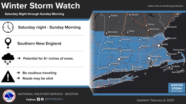
Most of Southern New England is under a Winter Storm Watch for Saturday night and Sunday morning. Image provided by the National Weather Service Office in Norton, MA.
Low pressure pulls away from the region tonight and high pressure builds in, with clearing skies along with breezy and chilly conditions. The high will remain in control into Saturday, with diminishing winds Friday night, resulting in a rather chilly night. Clouds start to move back in later Saturday as another low pressure system heads our way. Unlike today’s storm, this one will be a little colder, and have a little more moisture to work with, so we’re looking at mostly snow for a good chunk of the region, possibly a little rain across the South Coast and Cape Cod. The snow will likely start around midnight Saturday night, give or take an hour or two, and continue into Sunday afternoon before winding down. This will not be a blockbuster snowstorm, but light to moderate amounts are likely. We’ll have another post tomorrow with a more detailed look at the storm, but our preliminary thoughts on accumulations are 4-7″ for most of the area. We’ll clear out Sunday night behind the storm, then high pressure builds back in for Monday. Our active weather pattern will continue into next week with more storm systems heading our way. More details on that in our Weekly Outlook early Monday.
Our preliminary forecast of 4-7″ falls in line with what most of the models show right now. Images provided by Pivotal Weather.
Thursday night: Mostly cloudy, some clearing late at night. Low 25-32, temperatures may rise a little overnight.
Friday: A mix of sun and clouds, breezy. High 33-40.
Friday night: Clear to partly cloudy. Low 14-21.
Saturday: Some morning sun, then increasing and thickening clouds. High 28-35.
Saturday night: Cloudy with snow developing around midnight. Low 19-26.
Sunday: Snow ending by early afternoon, some late-day clearing. High 28-35.
Happy Truck Day to all who celebrate. While it’s a sign that Spring is on the way, Mother Nature won’t be providing too many other signs of Spring this week.
The first sign of spring is upon us – Monday is Red Sox Truck Day, when all of the equipment gets loaded up and shipped down to Fort Myers for spring training. Image provided by Boston.com
We’re starting the week off on a mild note. The low pressure system that brought us some light snow and rain will drag a warm front through this morning, allowing milder air to flow into the region on south to southwest winds. We’ll see some limited sunshine, but if it ends up being more widespread than we expect, temperatures could jump into the 50s. A cold front moves through tonight, possibly producing some rain showers in a few spots. High pressure builds in behind the system with sunshine accompanied by breezy and cooler conditions on Tuesday. The high will remain in control on Wednesday keeping us seasonably chilly, but clouds will start to stream in during the day ahead of the next storm system. There is a bit of uncertainty with this system, but we’ll likely see some snow developing across the region before daybreak on Thursday. A change to rain is likely south of the Mass Pike, but it’s the area from the Pike northward into southern New Hampshire that is a big question mark. Warmer air will likely move in aloft, allowing for a change to freezing rain and sleet, but how far north does the warmer air get at the surface? Some models bring it all the way into southern New Hampshire with a change to plain rain, some keep the colder air locked in at the surface, with the wintry mix and resulting hazardous travel conditions continuing into the afternoon, and some even keep it all snow across parts of southern New Hampshire and even northern Massachusetts. It’s a little too early to decide which way to lean with this, so we’ll continue to monitor it, and if there is enough of a threat of wintry weather, we’ll write a separate blog about it on Wednesday.
Right now the models all have different ideas about Thursday storm system Images provided by Pivotal Weather.
The precipitation winds down later Thursday as the system moves offshore, then high pressure builds in for Friday and Saturday with dry and colder weather. The next system heads out way for late Saturday into at least part of Sunday. This one looks a little colder, with snow becoming a better bet across much of the region, though the South Coast and Cape Cod may see some rain. This system also looks to contain a little more moisture so there is the potential for a decent-sized storm, especially across the interior, but this is still nearly a week away, so things can and will change numerous times between now and then. We’ll have more details on this system in our Weekend Outlook on Thursday, but we wanted to give you plenty of heads up on this one, since a lot of people tend to travel to parties on Super Bowl Sunday.
The models aren’t on the same page for Saturday night and Sunday either. Images provided by Pivotal Weather,
Monday: Becoming partly sunny. High 38-45.
Monday night: Mostly cloudy, chance for a few showers, some clearing late at night. Low 29-36.
Tuesday: Partly to mostly sunny, breezy, and colder. High 34-41 in the morning, temperatures drop in the afternoon.
Tuesday night: Clear to partly cloudy. Low 10-17.
Wednesday: A mix of sun and clouds. High 24-31.
Wednesday night: Becoming cloudy, snow developing late at night, possibly some rain near the South Coast and Cape Cod. Low 12-19 during the evening, temperatures start rising after midnight.
Thursday: Cloudy and breezy with snow changing to rain from Mass Pike southward, snow may change to sleet, freezing rain or plain rain north of the Mass Pike. Precipitation ends late in the day. High 36-43.
Our first snowstorm of the winter is on the way for Sunday night and early Monday.
A cold front is moving offshore this morning, setting the stage for our snowstorm tonight. Image provided by the Weather Prediction Center.
The cold front that brought us some rain Saturday evening has moved offshore and it will slow down today, with a wave of low pressure riding up along it tonight and early Monday. Clouds will move back into the region this afternoon ahead of this wave, with snow developing from southwest to northeast by late afternoon/early evening. Temperatures will be warm enough for the precipitation to start as rain across Cape Cod and parts of southeastern Massachusetts, but even there, the rain/snow line will collapse southward tonight. With temperatures dropping during the evening and overnight, the snow will be more fluffy, especially north and west of Boston. During the evening hours, we could see a burst of moderate to even heavy snow, with some places picking up an inch or so per hour. The snow should taper off to snow showers after midnight, but likely won’t end until shortly before daybreak on Monday.
Low pressure will pass south and east of the region tonight. Loop provided by Tropical Tidbits.
So, how much can we expect? North and west of I-95 most places will see 4-8 inches by the time everything winds down Monday morning. South and east of I-95, we’re looking at 3-6 inches, since there may be a little rain to start, and the snow won’t be as fluffy with temperatures a little milder. Once you get down to the South Coast, it’ll be more like 2-4 inches due to the rain at the start, with 1-3 inches across Cape Cod, heaviest towards the Canal.
A light to moderate snowstorm is expected for most of us tonight. Image provided by WeatherBell.
Make sure you clean up your driveway Monday morning. Gusty winds behind the system will result in a little blowing and drifting snow, but it’s going to turn much colder for a few days. Temperatures on Monday may not get back up to 20 in the afternoon, and we’ll likely stay in the teens during the day on Tuesday and Wednesday, with wind chills near or below zero. Night time lows will also be in the single digits or below zero for many of us as well. We’ll have more details on this in our Weekly Outlook early Monday.
We’re going to end 2024 on a stormy note, but 2025 begins with colder weather.
We’re starting the week off on a warm but wet note as a cold front makes its way across the region. Rain should end before midday, with gusty southerly winds keeping us mild ahead of the front. Once the front moves through, we’ll quickly clear out, but temperatures won’t drop that quickly. High pressure builds in for Tuesday with some sunshine and temperatures remaining fairly mild for late-December, but that won’t last long. Another low pressure system quickly follows, with another round of rain likely Tuesday night into Wednesday, so if you’ve got outdoor plans for New Year’s Eve make sure you bring an umbrella. This will help put another dent into the ongoing drought, but it will take a lot more rain to end that. Once that system moves out, high pressure builds in for Thursday through the weekend with breezy and colder weather, though a few flurries are possible at times.
Much of the region could pick up half an inch to an inch of rain on Wednesday. Image provided by Weathermodels.com
Normally, we don’t forecast more than a week out, but we felt that it was worth mentioning what is going to happen during the following week. You’ll see in our forecast that temperatures gradually get colder as we go through the end of this week and the weekend, but all indications are that starting next week, a much colder airmass is going to settle in, and it may remain in place for a good chunk of January. Temperatures will be below to perhaps well below normal, and there may be some days, especially toward mid-month, where high temperatures struggle to reach 20, and low temperatures could drop below zero in parts of the region. There are also some indications that next week could be stormy, with the potential for one or two storms impacting the region, but this is far less certain. It’s way too early for any details on any potential storm systems, but the cold air seems far more likely, so we figured a heads up was warranted at this point.
Temperatures could be well below normal during the first full week of January. Image provided by WeatherBell.
Monday: Rain ending in the morning, skies start to clear out in the afternoon, breezy, especially in the morning. High 50-57.
Monday night: Mostly clear. Low 32-39.
Tuesday: Morning sun gives way to increasing afternoon clouds. High 44-51.
Tuesday night: Becoming cloudy with rain likely, possibly heavy at times. Low 34-41 during the evening, temperatures start rising after midnight.
Wednesday: Cloudy and breezy with rain tapering off to showers ending in the afternoon. High 43-50.
Thursday: A mix of sun and clouds, windy, and colder. High 34-41.
Friday: Partly to mostly sunny, breezy. High 30-37.
Saturday: Partly sunny, breezy. High 28-35.
Sunday: A mix of sun and clouds, breezy. High 25-32.
If you’re happy that you had a White Christmas but want the snow gone now then you’re in luck because it will turn milder this weekend, but there’s also some rain on the way, and possibly some icing issues as well.
Much of the region could pick up an inch or more of rain between now and Monday evening. Image provided by Weathermodels.com
High pressure will keep us dry into Saturday, with temperatures gradually moderating, helping to melt a little bit of the snow, but we’ll see clouds start to move in Friday night and Saturday as low pressure begins to head our way. Showers will move in late Saturday and Saturday night ahead of a warm front, but across the interior, especially from central and northeastern Massachusetts into southern New Hampshire, temperatures may be near or just below freezing Saturday night, which could result in some freezing rain for a while. Keep this in mind if you are going to be out and about in those areas Saturday evening and night. Temperatures should slowly warm up Sunday morning allowing the precipitation to change to all rain, with occasional showers likely during the day on Sunday. The low pressure system itself moves in for Sunday night and Monday, bringing some steadier and heavier rain in, allowing us to put another dent into the ongoing drought. The rain moves out during the day on Monday, with some clearing possible by late in the day.
Freezing rain could be an issue north and west of Boston Saturday night. Image provided by WeatherBell.
Thursday night: Gradual clearing across Cape Cod, clear to partly cloudy elsewhere. Low 12-19, milder across southeastern Massachusetts and Cape Cod.
Friday: Sunshine in the morning, clouds start to filter in during the afternoon. High 35-42.
Friday night: Becoming partly to mostly cloudy. Low 20-27, a little milder across Cape Cod.
Saturday: Mostly cloudy with a few showers around during the afternoon. High 32-39, except 40-47 across southeastern Massachusetts and Cape Cod.
Saturday night: Cloudy with some occasional showers, some freezing rain or freezing drizzle likely outside of I-495. Low 30-37 north of the Mass Pike, except 37-44 across southeastern Massachusetts and Cape Cod, with temperatures possibly rising after midnight.
Sunday: Cloudy with more showers, possibly some freezing drizzle or freezing rain across southern New Hampshire in the morning. Some steadier rain may move in late in the day. High 39-46 north of Route 2, 46-53 south of Route 2.
Sunday night: Periods of rain, some of it could be heavy. Low 37-44 during the evening, temperatures may rise overnight.
Monday: Rain ends in the morning, some clearing possible late in the day, breezy. High 48-55.
The first half of the week is looking quite active, with all sorts of hazardous weather for the region.
Some much-needed rainfall is expected today and Wednesday, Image provided by WeatherBell.
The week starts off with high pressure over Quebec keeping us dry, but that won’t last long. Low pressure heading into the Great Lakes sends some clouds our way, then a secondary low pressure system will develop, passing across southern New England tonight and early Tuesday. The result will be a period of rain for much of the region, starting late this afternoon, and ending shortly after midnight, but that’s not the entire story. Across southern New Hampshire, temperatures may be cold enough for the precipitation to start as snow, with some accumulation expected, mainly from Manchester northward. By evening, warmer air will move in aloft, but cold air may get trapped at the surface, so we could be looking some freezing rain, again, mostly from Manchester northward. Precipitation tapers off to drizzle or freezing drizzle after midnight as the system pulls away. Tuesday looks to be a cloudy day with some patchy drizzle at times, and temperatures holding steady or only very slowly rising as we head through much of the day.
Most of the snow we’re expecting tonight will be across southern and central New Hampshire. Image provided by Weathermodels.com
Another low pressure will start to make its way toward us Tuesday night into Wednesday, and this one will have some significant impacts on the region. We’ll see rain developing Tuesday night, continuing into Wednesday and it could be heavy at times. Many models are showing the potential for 1-2 inches of rain (or more), which would help put a dent in the ongoing drought. Accompanying the rain will be gusty south to southwest winds. Many models are showing the potential for wind gusts in excess of 40 mph across the region, with several showing even stronger winds, especially across eastern and southeastern Massachusetts. We’re skeptical that winds could be as strong as some of the models are showing, but it will be a windy day for sure. Those winds will also bring unseasonably warm air in, with temperatures likely getting well into the 50s across much of the region, with some places possibly topping 60. As the system passes by Wednesday night, it will drag a strong cold front through near or just after midnight. This will bring a quick end to the rainfall, but will also usher much colder air into the region. Many places could still be in the 50s or warmer at midnight, but will drop into the 30s by daybreak, and then hold steady or drop some more during the daytime hours despite clearing skies.
Gusty winds are likely on Tuesday, with the potential for wind gusts over 40 mph. Image provided by WeatherBell.
High pressure builds in for later Thursday into Saturday with mainly dry and cool conditions. Sunday is a bit of a question mark at this point. Some models show the potential for another system to move in with unsettled weather, some delay that storm until Monday, and some have it stay well to our south. At this point, it’s just too early to determine which, if any, solution is correct, so we’ll worry more about that in our Weekend Outlook on Thursday.
Sunday’s weather is a big question mark at this point. Images provided by Pivotal Weather.
Monday: Some morning sun, then becoming mostly cloudy with rain developing late in the day, except snow developing in southern New Hampshire. High 40-47.
Monday night: Cloudy, snow changing to freezing rain and potentially plain rain across southern New Hampshire, showers across the rest of the region, with everything winding down shortly after midnight, but a little drizzle or freezing drizzle may linger late at night. Low 28-35 north and west of I-95, 36-43 south and east of I-95.
Tuesday: Plenty of clouds with some spotty drizzle, maybe some freezing drizzle across southern New Hampshire. High 33-40 north of the Mass Pike 41-48 south of the Pike, a little warmer across Cape Cod and the South Coast.
Tuesday night: Cloudy with showers developing, possibly starting as a little freezing rain across central New Hampshire. Low 32-39 during the evening north and west of I-95, 40-47 south and east of I-95, temperatures slowly rise overnight.
Wednesday: Cloudy with periods of rain, some of it could be heavy, becoming windy. Rain ends shortly after midnight. High 56-63.
Thursday: Becoming partly sunny, breezy, especially in the morning. High 36-43 early, temperatures hold steady or drop during the day.
Friday: Sunshine and some afternoon clouds. High 30-37.
Saturday: Mostly sunny in the morning, clouds start to move in during the afternoon. High 34-41.
Sunday: Partly to mostly cloudy with a chance of rain, especially late in the day. High 38-45.