Temperatures will be quite mild for half the week, and quite chilly for half the week. In between, some much needed rain is on the way.
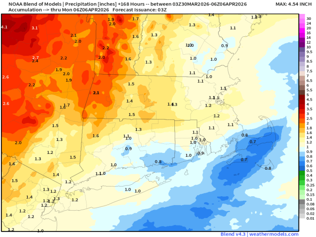
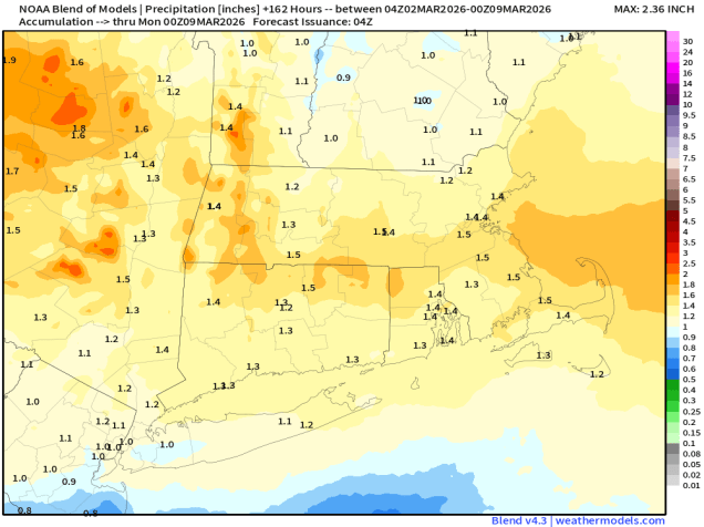
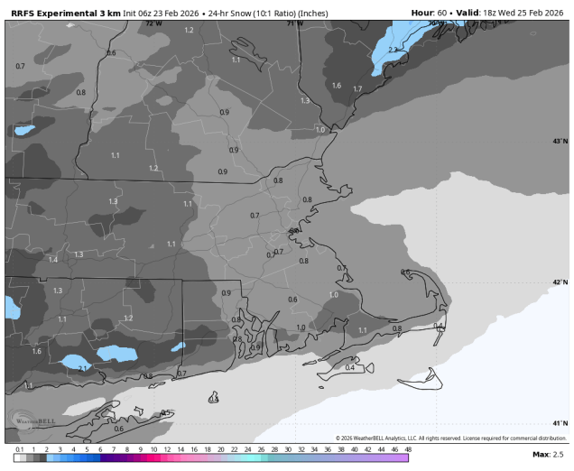
Parts of the region could see an inch or so of rainfall this week. Image provided by Weathermodels.com
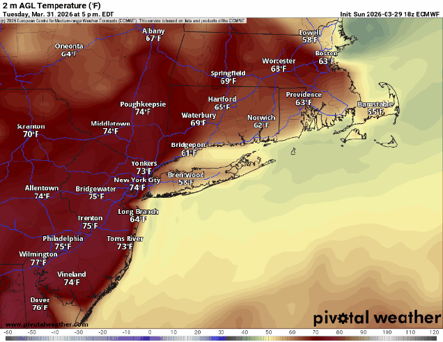
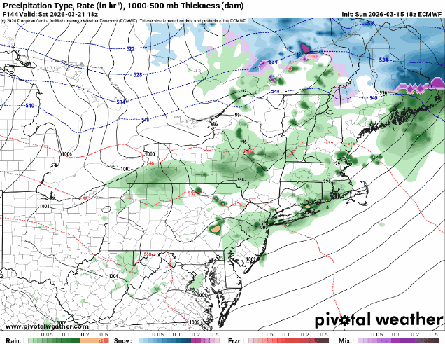
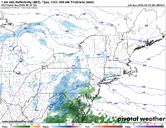
The week starts off with high pressure moving off the East Coast, with southwest winds around the high bringing milder weather in, though the South Coast and Cape Cod will remain cooler as a southwest wind is a seabreeze off the still-chilly Atlantic. Tuesday could be a bit trickier. A backdoor cold front will be dropping southward, bringing some showers into the region. How far south the front gets before stalling out will have a big impact on the temperature forecast. South of the front, temperatures will likely get into 60s (cooler near the South Coast), while north of the front, temperatures will only be in the 40s. This boundary will lift back northward at night.
Temperatures Tuesday afternoon will be highly dependent on the location of a backdoor cold front.
Wednesday will likely be a mild day across the region, but low pressure crossing northern New England will drag a cold front through, with another round of showers and possibly some thunderstorms ahead of the front during the afternoon. Much cooler air settles in behind the front for Wednesday night and Thursday, but the front will stall out to our south and a wave of low pressure will ride along it, bringing in some additional rainfall. Friday has the potential to be another tricky day, and it’s also the Red Sox home opener, so a lot of people will be paying attention to this forecast. Another wave of low pressure will ride along the front late Friday and Friday night, with some more showers, but for now, it looks like much of the day will stay dry. The question is in the temperature forecast. Some models have the wave passing farther north, bringing the front back through as a warm front, some keep it farther south, with chilly weather remaining in place. Some additional showers possible on Saturday, then Sunday looks similar to Friday, with another system possibly dragging the front northward, allowing warmer air to briefly return before showers and another cold front move in.
Opening Day looks cloudy, and potentially mild, but dry, for now at least. Image provided by Major League Baseball.
Monday: Intervals of clouds and sun, breezy. High 60-67, cooler near the South Coast and Cape Cod.
Monday night: Partly to mostly cloudy, chance for some late-night showers. Low 43-50.
Tuesday: More clouds than sun with some showers likely, especially in the morning. High 58-65, cooler near the South Coast and Cape Cod, temperatures may drop during the afternoon, especially along the coast and into parts of northeastern Massachusetts and southern New Hampshire..
Tuesday night: Partly to mostly cloudy, breezy, chance for a shower or two. Low 42-49, temperatures start to rise after midnight.
Wednesday: Plenty of clouds with a few sunny breaks early, breezy, showers developing in the afternoon, possibly a thunderstorm. High 67-74, cooler near the South Coast and Cape Cod.
Wednesday night: Mostly cloudy with more showers, mainly during the evening. Low 34-41.
Thursday: Lots of clouds, chance for a few showers, much cooler. High 39-46.
Thursday night: Cloudy with some showers possible. Low 31-38.
Friday: Mostly cloudy. High 51-58.
Saturday: Mostly cloudy, chance for a few showers. High 50-57.
Sunday: Cloudy with a chance for more showers. High 57-64.
The week is going to start off with a potent storm system heading our way.
A couple of batches of rain are likely today and tonight, maybe even some thunderstorms. Loop provided by Weathermodels.com
The low pressure system bringing blizzard conditions to the Great Lakes will impact us over the next 36 hours, but not with blizzard conditions. A warm front extending eastward from the system will cross the region today, with some rain ahead of it through the morning hours. Once the front moves through, gusty southerly winds will bring milder air back in, but the rain will taper off to some widely scattered showers. However, steadier and heavier rain will return by evening as a cold front begins to approach from the west. A line of thunderstorms may accompany the front tonight, though any severe weather will likely be well to our south. Rain ends by daybreak Tuesday as the front pushes offshore, with gusty west winds behind the front bringing much colder air back in. While we’ll start to clear out in the morning, a secondary cold front will bring some clouds back in during the afternoon, with a few stray flurries possible.
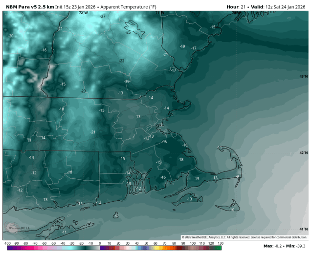
Temperatures will get into the 60s across much of the region Monday evening ahead of the cold front. Image provided by WeatherBell.
High pressure builds in with dry and chilly conditions for Wednesday, but as it slides off to the east, temperatures will start to moderate for Thursday and Friday. Another system may move in for the weekend, but there is a lot of uncertainty with this storm, with some rain or snow possible, depending on the eventual evolution of the system. We should have more clarity by the time we get to our Weekend Outlook on Thursday.
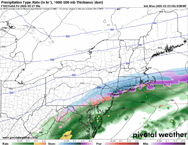
The models all have different ideas about a potential storm next weekend. Images provided by Pivotal Weather.
Monday: Cloudy and becoming windy with rain during the morning, tapering off to occasional showers during the afternoon. High 55-62.
Monday night: Windy with rain redeveloping, possibly heavy at times, some thunderstorms are possible. Rain ends before daybreak. Low 34-41.
Tuesday: Becoming partly sunny, breezy, chance for a few late-day flurries. Temperatures hold steady or drop during the daytime.
An active weather pattern will provide us with a little bit of everything this week.
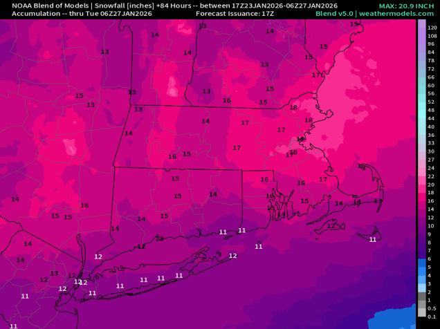
Much of the region could see a pretty decent amount of precipitation this week. Image provided by weathermodels.com
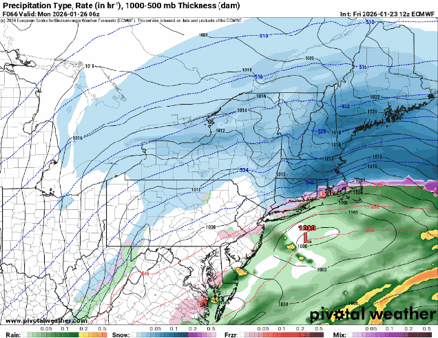
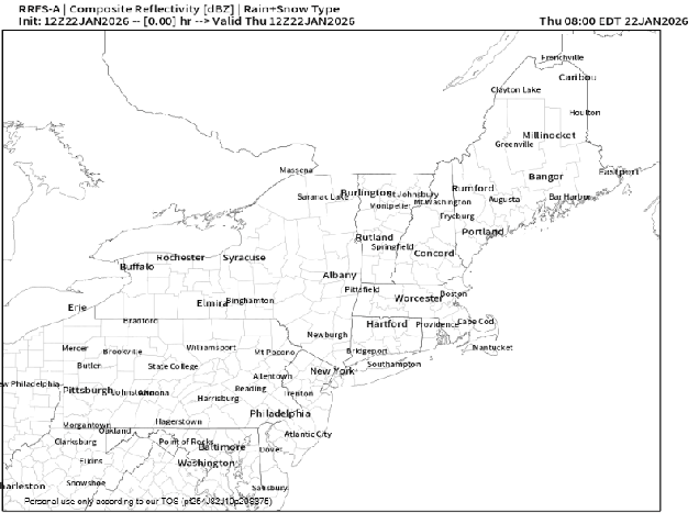
The week starts off quiet with high pressure in control giving us a rather chilly day, but that won’t last too long. A wavy frontal system will start to lift northward on Tuesday as a wave of low pressure rides along it. With cold air in place, we’ll see snow moving in Tuesday afternoon, but it will quickly change to rain south of the Mass Pike as warmer air moves in. North of the Pike, the colder air will take a little longer to scour out, but warmer air will move in aloft, so we’ll likely see a period of freezing rain Tuesday evening before a change to plain rain at night before the precipitation comes to an end. Wednesday looks like a calmer day, and likely a bit milder, with some sunshine. That front will lift northward as a warm front on Thursday, bringing us a mild day with more rain. While this will help melt some of the glacier that we still have in place, it may also cause some problems, as the ground remains frozen, so that water will have nowhere to go. While we’re not going to have widespread flooding, there could be some issues, especially along some of the rivers as the ice breaks up and starts to flow downstream, with ice jams possibly resulting in some flooding issues. The front drops southward as a backdoor cold front late Thursday and Friday, with another wave of low pressure moving along it. As the colder air moves back in, we could see a period of sleet or freezing rain across the interior once again. The front may lift back northward as a warm front on Saturday, before a stronger cold front moves in from the northwest on Sunday.
Tuesday’s afternoon commute could be messy, especially north and west of Boston. Images provided by Pivotal Weather.
Monday: Sunshine and a few clouds. High 21-28.
Monday night: Clear and cold, clouds start to drift in late at night. Low 8-15.
Tuesday: Becoming mostly cloudy, light snow developing in the afternoon, quickly changing to rain south of the Mass Pike. High 34-41.
Tuesday night: Cloudy with rain likely south of the Mass Pike, snow changing to freezing rain and possibly plain rain north of the Mass Pike, ending before daybreak. Low 27-34 during the evening, temperatures hold steady or slowly rise overnight.
Wednesday: Clouds give way to some sunshine, chance for a few showers. High 43-50, cooler along the coast and across Cape Cod.
Wednesday night: Becoming mostly cloudy, showers developing late at night. Low 28-35.
Thursday: Cloudy with some showers likely. High 43-50.
Thursday night: Rain likely, possibly changing to sleet or freezing rain across southern New Hampshire and interior northern Massachusetts. Low 29-36.
Friday: Cloudy with some areas of freezing drizzle or sleet across the interior, plain drizzle elsewhere. High 35-42.
Saturday: Plenty of clouds with more showers, possibly some freezing rain well inland in the morning. High 47-54.
Sunday: Mostly cloudy with more showers possible. High 51-58, cooler across Cape Cod.
The blizzard rages on today, but there are still two more chances for snow this week.
There’s still a lot of snow left today, but not the outrageous amounts some places were forecasting. Image provided by weathermodels.com
Intensifying low pressure passes south and east of New England today with heavy snow, strong winds, and coastal flooding likely. The snow will be heavy through the morning, then start to taper off in the afternoon, ending during the evening. We’re looking at 10-18 inches across much of the region, a little less across southern New Hampshire, on the order of 6-10 inches. Winds will gust to 30-50 mph inland, and 50 to perhaps 70 mph along the coast, with significant blowing and drifting snow likely. Temperatures will slowly fall during the day, so the snow will become a little fluffier, allowing the blowing and drifting to become more of an issue. Winds will start to diminish later today as the storm pulls away, but it will remain breezy into Tuesday morning. High pressure builds in with some sunshine returning on Tuesday, but it won’t last too long. Clouds come right back at night as an Alberta Clipper heads our way. Some light snow will develop towards daybreak on Wednesday, ending by early afternoon. Temperatures may be marginally warm enough for the snow to mix with or change to rain south of the Mass Pike. Overall, with it being a weak and fast-moving storm, we’re not expecting more than 1-2 inches of snow anywhere.
A little bit of light snow could make the Wednesday morning commute interesting. Image provided by WeatherBell.
We’ll clear out at night and to start the day Thursday, but then another system quickly heads our way for Thursday night and early Friday. There’s a bit more uncertainty with this one – some models have a change to rain with the storm passing to the north, some keep the storm farther south with less rain, but a shift southward where the snow falls. Some models show light accumulations, some heavier. For now, it doesn’t look like a big storm, but we’ll see how things progress as the week goes on. High pressure brings in drier weather for later Friday and the weekend.
There’s some uncertainty with the system for Thursday night. Images provided by Pivotal Weather.
Monday: Windy with snow, heavy at times through the morning, tapering off during the afternoon. High 26-33, temperatures start to drop by late morning.
Monday night: Snow showers end during the evening, some late-night clearing, still breezy. Low 15-22.
Tuesday: Partly to mostly sunny, breezy. High 24-31.
Tuesday night: Clouds stream in, snow showers possible towards daybreak. Low 5-12, temperatures start to rise after midnight.
Wednesday: Light snow or snow showers, possibly mixed with rain south of the Mass Pike, ending in the afternoon. Accumulations of a coating to 2 inches possible. High 32-39.
Wednesday night: Becoming clear to partly cloudy. Low 19-26.
Thursday: Morning sun, then increasing clouds, snow possible by evening. High 33-40.
Thursday night: Cloudy with some snow or rain likely. Low 22-29.
Friday: Snow or rain ends early, skies start to clear out in the afternoon. High 34-41.
Before we get to the bad news (i.e. the rest of this blog post), we’d like to remind you that Red Sox Opening Day is just 33 days away.
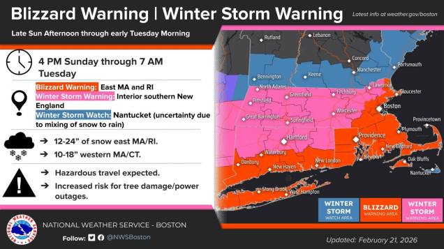
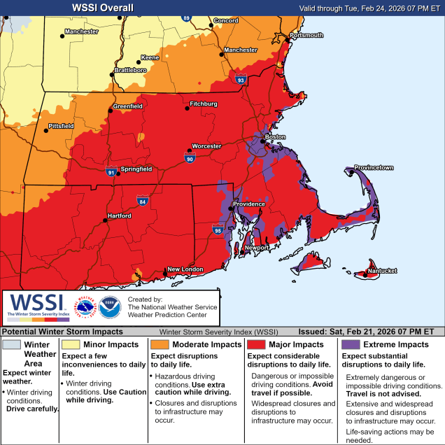
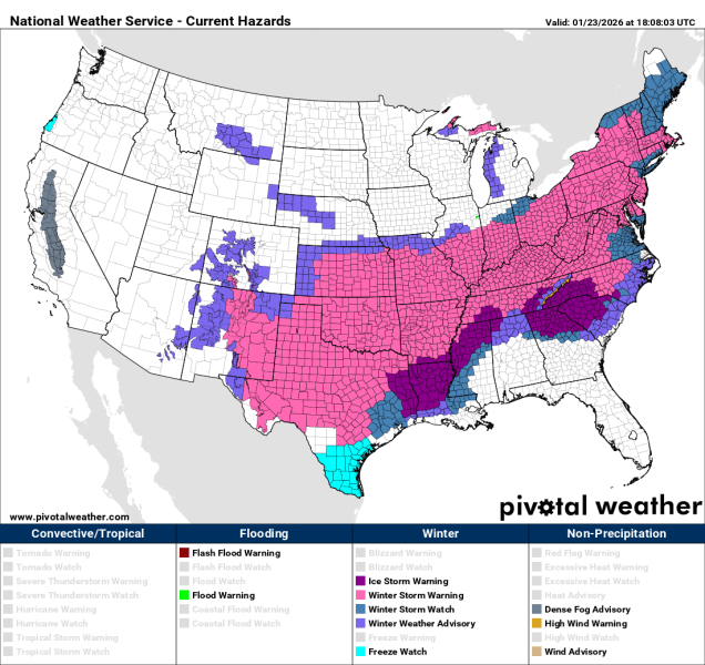
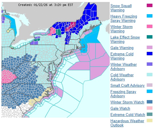
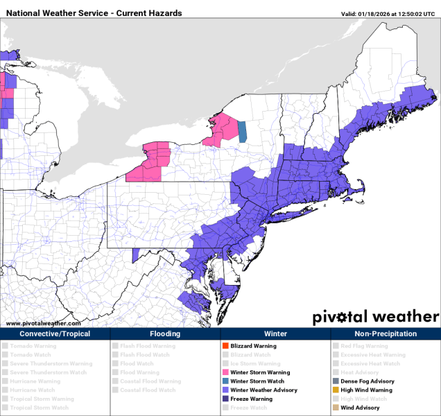
A variety of Watches and Warnings are in effect across the region. Image provided by the National Weather Service office in Norton, MA
Unless you’ve been unconscious for the past several days, you may have heard that we’ve got a storm on our way that the media has been going off the deep end about. As a result, we at Storm HQ are issuing an Extreme Hype Warning. When an Extreme Hype Warning has been issued, that means you’ll see blanket coverage from the network stations around here, hourly updates even when they go to regular programming, and of course, obligatory live shots from (take your pick):
The side of an Interstate
Logan Airport
A local DPW salt pile
A beach showing the rough surf and coastal flooding
A Dunkin Donuts where they are talking to a plow operator
All of the above
You’ll also get network reports about how the snow is creating chaos in New York City, and in some cases, but likely not this one, how it put Washington at a standstill, and possibly how it dumped heavy snow on the Midwest. The latter is debatable, because anything west of the Appalachians is considered “flyover country” to the media around here.
This storm will have major to extreme impact on the region. Image provided by the Weather Prediction Center.
Having said that, let’s get to the details. Low pressure will move off the Carolina coastline early Sunday, then head northeastward while rapidly strengthening later Sunday into Monday, passing south and east of Nantucket late Monday. This storm will have 3 main impacts on our region: Strong winds, coastal flooding, and heavy snow. We’ll address those in order.
The system will impact our area for roughly 24 hours. Loop provided by Pivotal Weather.
Our low pressure system, which isn’t that strong at the moment (central pressure around 1012mb – 29.88″), will quickly strengthen late Sunday and Monday, with its lowest pressure dropping to around or even under 970mb (28.64″), which is equivalent to a Category 2 Hurricane. There’s a term that sounds scary (and is overused by the media) to describe this called “bombogenesis”. All that means is that the central pressure of the storm dropped by at least 24mb over a 24-hour span – the storm “bombed out”. As the pressure drops in the storm, the gradient between it and high pressure to the north increases, which is what generates wind. The larger the difference in pressure over a smaller area, the tighter the gradient and thus the stronger the wind. The winds will start to pick up Sunday afternoon, but the strong winds are likely Sunday night into Monday morning. We’re looking at sustained winds of 20-30 mph inland, and 30-40 mph along the coast, especially from Boston southward, with sustained winds of 40-50 mph possibly across parts of Cape Cod and the South Coast. In terms of wind gusts, we’re looking at 40 to 50 mph north and west of Boston, 50-70 mph south of Boston, and perhaps to hurricane force on Cape Cod and the Islands. This will also certainly result in trees and powerlines down along with other wind damage, so be prepared for the power to go out.
Wind gusts in excess of 40 mph are likely across most of the region. Image provided by WeatherBell.
Coastal flooding is our next concern, and the wind is the primary driver of that. Tides are not astronomically high (we lucked out there!), but persistent east to northeasterly winds will continue push the ocean towards east-facing shorelines. As a result, some minor to perhaps moderate coastal flooding is expected with the high tides by Monday morning and Monday afternoon along the coast of eastern Massachusetts, especially the usually vulnerable locations. As winds shift into the north behind the storm later Monday, the threat will diminish across eastern Massachusetts, but will increase across places with north-facing coastline, like Cape Cod, Martha’s Vineyard, and Nantucket.
Minor to moderate coastal flooding is a concern with this storm. Image provided by the National Weather Service office in Norton, MA
This brings us to the part most of you want to hear about – snow. There may be a few flurries around during the afternoon along the coast as northeast winds start to increase and pick up a little moisture from the ocean, but the steady snow associated with the storm itself will move in from southwest to northeast as early as 5pm in parts of southern Rhode Island, and as late as 10pm or so into southern New Hampshire. The intensity will quickly pick up, with moderate to occasionally heavy snow overnight. Right now the heaviest snow, possibly falling at a rate of 1-3 inches per hour, looks to be during what would normally be the morning commute, 5-10am. After that, it will taper off a little, but light to occasionally moderate snow will continue through the afternoon, likely ending from west to east between 6 and 8pm.
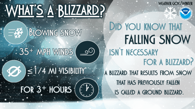
When you factor in the wind, we’ll have blizzard conditions, especially near the coast, where Blizzard Warnings have been issued. The amount of snow a storm produces has nothing to do with whether it is a blizzard or not. In fact, you can have Blizzard conditions without any snow falling at all! To qualify as a blizzard, you must have sustained winds of 35 mph or frequent gusts to 35 mph or more AND visibility of 1/4 mile or less for 3 consecutive hours. We could very well get this combination, especially along the coast, Monday morning. Travel is not recommended on Monday at all, at least until conditions start to improve late in the day.
You don’t need falling snow to have a blizzard. Image provided by the National Weather Service.
So, how much snow are we expecting? There are plenty of people out there more than willing to share model forecast maps showing widespread 20-30 inch amounts, but we’re not buying that. As a colleague of ours pointed out online earlier, this will be a heavy, wet snow, so it won’t pile up as quickly (but will be a huge pain to shovel!), plus, there probably won’t be enough precipitation to generate that much snow. Could it happen? Sure, it could, but right now, we’re not expecting. What we are expecting is widespread 10-18″ across most of eastern Massachusetts and Rhode Island, with 8-14″ across southern New Hampshire. As is usually the case, there will be some isolated heavier amounts in these regions where bands of heavy snow stick around a little longer.
A foot or more is expected across much of the region. Image provided by Weathermodels.com
While you’re digging out from this storm, other systems may produce a little more snow Wednesday and again Friday. We’ll detail those in our Weekly Outlook early Monday morning.
Once the snow finally winds down today, chilly weather will move back in for much of the week.
Temperatures will be well below normal this week. Image provided by WeatherBell.
Low pressure will slowly pull away from the region today, with occasional light snow or snow showers for a good chunk of the day, especially north of the Mass Pike, where additional accumulations of 2-4 inches are possible (less is expected to the south). We’ll see some clearing tonight, but clouds will fill back in on Tuesday as an upper-level disturbance crosses the region, keeping temperatures on the chilly side. Another disturbance moves in on Wednesday, which may produce a few snow showers late in the day and at night. High pressure then builds in with dry and cold conditions for the latter half of the week and into the weekend. We are keeping an eye on an ocean storm late in the weekend. It’s too early to tell whether it will stay offshore with no impact or pass close enough to bring us more snow on Sunday.
Another week of model roulette awaits us. Images provided by Pivotal Weather.
Monday: Cloudy with occasional light snow and snow showers, ending by evening, breezy along the coast. Additional accumulation 2-4″ north of the Mass Pike, less than 2″ south of the Pike. High 19-26 north and west of Boston, 27-34 in the morning south of Boston with temperatures falling through the day.
Monday night: Any lingering snow showers end in the evening, becoming clear after midnight, breezy. Low 4-11.
Tuesday: Sunny in the morning, becoming partly to mostly cloudy in the afternoon. High 17-24.
Tuesday night: Becoming clear. Low -1 to +6, warmer across Cape Cod.
Wednesday: Morning sun, then clouds return. High 16-23.
Wednesday night: Partly to mostly cloudy, slight chance for a snow shower. Low -1 to +6, warmer across Cape Cod.
Thursday: Intervals of clouds and sun. High 16-23.
Thursday night: Becoming clear. Low -3 to +4.
Friday: A mix of sun and clouds. High 13-20.
Saturday: Mostly sunny. High 19-26.
Sunday: Intervals of clouds and sun, chance for snow. High 24-31.
The biggest snowstorm this area has seen in a few years is on the way, with arctic air preceding it.
Winter Storm Warnings are in effect from New Mexico to New England. Image provided by Pivotal Weather.
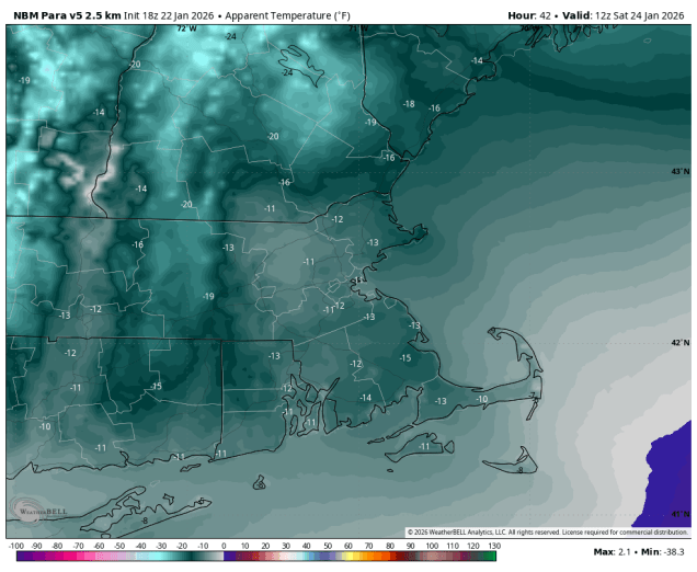
An arctic cold front will cross the region later today, producing a few snow showers or squalls, but gusty northwest winds behind the system will usher in the coldest air so far this winter for the weekend. Temperatures will plunge into the single numbers tonight with some subzero readings possible. When you factor in the wind, it will feel like it is 10 to 20 below zero if you are outside Saturday morning. Despite some sunshine, temperatures will struggle to reach the teens on Saturday, but the wind will subside. We’ll see high clouds start to stream in during the afternoon as a developing low pressure system heads our way.
Bundle up if you need to head outside for any reason Saturday morning. Image provided by WeatherBell.
That system will move into the Deep South, and a secondary area of low pressure will develop near the Carolinas or Virginia Tidewater region. as it starts to strengthen it will move northeastward, passing south and east of New England Sunday night and Monday. There is still a little question as to how far north the low gets, which has some implications on the forecast, as it could result in some sleet near the South Coast, but for the bulk of the region, we’re looking at snow, thanks to the cold air already in place.
The storm will bring wintry weather to a very large area this weekend. Loop provided by weathermodels.com
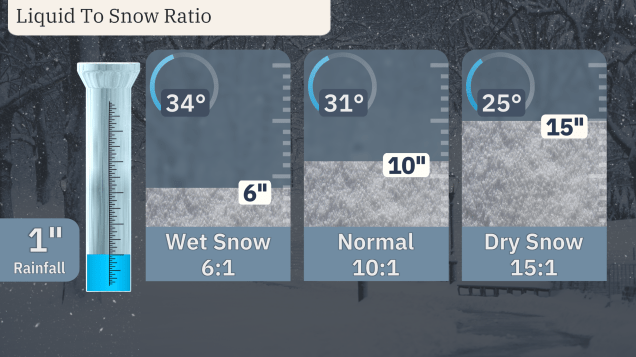
Because it will be so cold for much of the region, it will be a fluffier snow, which can pile up more quickly. The colder the air is, the less moisture it can hold. In general, 1 inch of liquid will result in 10 inches of snow when the temperature is near freezing. When temperatures are in the teens, as they will be across the interior for this storm, that ratio can change to as much as 15-20 inches of snow for 1 inch of liquid.
The colder the air, the fluffier the snow. Image provided by weather.com
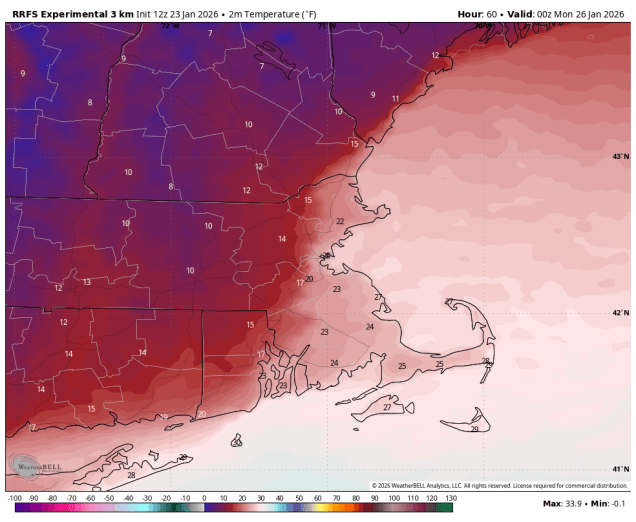
Closer to the coast, especially south of Boston, temperatures will not be nearly as cold, thanks to something meteorologists refer to as a “coastal front”. Ocean temperatures remain near or a little over 40, so as winds blow over that water and reach the coast, we will see temperatures moderate into the 20s, or even lower 30s, but that air usually doesn’t penetrate too far inland. So, you end up with a sharp boundary, or front, where temperatures go from the teens to the west and 20s to the east over a span of just a few miles. Exactly where that front sets up makes a big difference, not only because it’s the difference between fluffy snow and wet snow, but also because that front provides a little bit of lift, which usually results in some of the heaviest snow totals just to the west of that coastal front. As the system starts to pull away on Monday, that coastal front will quickly move southeastward, allowing the very cold air to quickly return to southeastern Massachusetts.
The coastal front is easy to find on temperature maps for Sunday evening. Image provided by WeatherBell.
For the timing, it looks like the snow will move in near or just after midday on Sunday from southwest to northeast, reaching southern New Hampshire by mid-afternoon. The steadiest and heaviest snow is likely from about 6pm to 2am. If there is going to be any sleet near the South Coast, it will likely be between about 10pm and 3am. As the storm starts to pull away on Monday, we’ll still see occasional light snow for much of the day, with some additional accumulations possible. Everything should finally wind down and end Monday evening.
Many models show the potential for some sleet near the South Coast around midnight Sunday night. Images provided by Pivotal Weather.
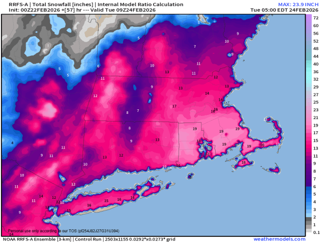
Now, the part you’re all waiting for – how much snow can we expect? There’s still a few details to be worked out that will impact the final numbers (where does the coastal front set up? will there be sleet near the South Coast?), but for the most part, we feel confident enough to put the pen to the paper so to speak. For most of the region, we’re looking at a general 12-18 inches. There will be some spots that get a little more, and there could be a little less near the South Coast, especially if there’s some sleet involved.
The NWS Blend of Models is mostly closely aligned with our thinking. Image provided by Weathermodels.com
In case you’re curious, the last time some cities around here received a foot or more in a single storm:
Boston: January 29, 2022 – 23.6″ Blue Hill: January 29-30, 2022 – 27.6″ Lowell: January 6-7, 2024 – 15.8″ Worcester: January 6-7, 2024 – 15.5″ Providence: January 28-29, 2022 – 19.3″ Hartford: February 1-2, 2021 – 12.1″ Manchester: December 1-3, 2019 – 20.8″
Once this storm pulls away, cold air will remain in place for much of the upcoming week, so don’t expect any melting any time soon.
You may have heard that there’s a little storm on the way. Well, before that happens, it’s also going to get ridiculously cold. We’ll get to all of that in this blog, but we’ll tell you right now, you won’t find a forecast for snow amounts. It’s too early for that, and there’s too much uncertainty still. We’ll tell you how we think the storm will evolve and its likely impacts around here, how cold it will get Before the Storm (and how that will impact things), and lots of musical references, but we’re not going to give you a snowfall forecast. We may do that in another blog post tomorrow, but for now, we’ll leave the hype to all of the TV meteorologists and Facebook Forecasters of the world.
A variety of watches, warnings and advisories are in effect across the eastern US. Image provided by the National Weather Service Eastern Region
After a somewhat mild day today, a cold front will move through this evening, possibly accompanied by a few snow showers, but the more noticeable effect will be cooler air moving in tonight. On Friday, an arctic cold front will cross the region, possibly with some additional snow showers or squalls, and that is what will start the Change in the Weather. Bitterly cold air will flood into the region behind that front. Temperatures will plunge into the single numbers and below zero across the region, with wind chills well below zero thanks to gusty northwest winds, making you dream about those Hot Summer Nights. A Cold Weather Advisory is in effect for much of the region. On Saturday, sunshine will start to fade as high Clouds Race Across the Sky, but it will remain Stone Cold, with high temperatures only getting into the teens at best, with wind chills still near or below zero before winds die down in the afternoon. Clouds will continue to stream in Saturday night, but it will remain chilly. This brings us to Sunday.
Wind chills of -10 to -20 are expected Saturday morning. Image provided by WeatherBell.
Low pressure moving into the Southwest will run into the arctic airmass covering much of the eastern two-thirds of the nation over the next few days. Moderate to heavy snow is expected from the Southern Plains across to the Tennessee Valley and parts of the Southeast and Mid-Atlantic states. To the south of these areas, a significant sleet and freezing rain storm is likely from parts of Texas into the Deep South. Places like Dallas, Little Rock and perhaps Nashville and Atlanta could be Trapped Under Ice by the end of the weekend. By Sunday, that system will move off the Carolina coast and head northeastward, developing as it passes south and east of Cape Cod early Monday. Sunday will start off cloudy and cold, with snow likely moving in by mid-to-late afternoon from southwest to northeast. With some very cold air in place, it will be more of a fluffy snow, easier to clean up, but it also piles up a lot more quickly. Snow will continue through the night, possibly heavy at times, slowly winding down during the day on Monday. The questions now are:
How much does the very dry air in place slow down the start of the snow on Sunday?
How heavy does the snow fall at times Sunday night into Monday?
When will the snow actually end?
How close will the system actually track to the coast?
Will temperatures get up close to freezing across parts of southeastern Massachusetts behind a coastal front?
Could there be some sleet and/or rain near the South Coast and Cape Cod?
With this many questions that we don’t have answers to at this point, it would be irresponsible to try and forecast snowfall totals, so we won’t do that. We will say that it is likely that much of the region gets 6 inches or more, but beyond that, we won’t commit to anything else.
After some snow showers/squalls tonight and Friday, you see the snow spreading in on Sunday. Loop provided by Weathermodels.com
Thursday night: Partly to mostly cloudy, chance for a few snow showers, skies start to clear out late at night. Low 16-23.
Friday: A mix of sun and clouds, chance for some snow showers or squalls, breezy. High 27-34.
Friday night: Becoming clear, breezy, and bitterly cold. Low -3 to +4, a little milder across Cape Cod.
Saturday: Sunny and breezy in the morning, high clouds stream in during the afternoon. High 10-17.
Saturday night: Becoming mostly cloudy. Low -1 to +6.
Sunday: Cloudy with snow developing by mid-to-late afternoon. High 13-20 north and west of I-95, 21-28 south and east.
Sunday night: Snow likely, possibly mixed with a little sleet or rain near the South Coast and Cape Cod, becoming breezy. Low 8-15 north and west of I-95, 16-23 south and east.
Monday: Snow gradually ending, breezy. High 16-23 north and west of I-95, 24-31 south and east.
After days of endless social media hype about a snowstorm this weekend, we’ve finally there and while it’s not a blockbuster blizzard, we do have some light to perhaps moderate snow on the way.
Winter Weather Advisories are in effect for portions of the Northeast. Image provided by Pivotal Weather.
A cold front is moving toward the East Coast this morning, with a wave of low pressure developing along it. At the same time, an upper-level disturbance is heading toward the Northeast. That disturbance will bring in some snow showers this morning, possibly mixed with some rain across parts of southeastern Massachusetts. While these snow showers may whiten the ground, we’re not expecting much accumulation with them. Meanwhile, low pressure developing off the Southeast coast will ride up the front, passing south and east of New England later today and tonight. The precipitation shield with that system will move in from the south later this afternoon, with snow for much of the region, except rain across parts of Cape Cod and perhaps southeastern Massachusetts. Even there, a change to snow is expected by evening as colder air moves in on the backside of the storm. Some steady snow is likely across much of the region from late afternoon through the evening, tapering off to snow showers after midnight. The snow showers may not end across parts of eastern Massachusetts until around daybreak on Monday as the storm pulls away.
Snow will spread across the region this afternoon and evening. Loop provided by WeatherBell.
In general, we’re looking at 3-5 inches. of snow for much of eastern Massachusetts, with a few heavier amounts possible. As you head farther north into the Merrimack Valley and Southern New Hampshire, as well as across parts of Cape Cod, totals will be a little lighter, generally 1-3 inches.
A general light to moderate snow is expected this afternoon and tonight. Image provided by Weathermodels.com
The weather could have an impact on the Patriots/Texans playoff game at Gillette Stadium this afternoon. Some occasional light snow is expected, with temperatures in the lower to middle 30s and light winds.
A pair of storm systems will impact our weather over the next few days, but mostly with rain, not snow.
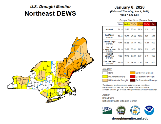
It’s been fairly dry so far this winter, so we’re still experiencing drought conditions across much of the region. Image provided by the National Drought Mitigation Center.
High pressure will slide off to the east tonight, with winds shifting into the southwest, bringing some milder air in. Friday will be relatively mild (by January standards), but clouds will be streaming in ahead of a low pressure system headed for the Great Lakes. As that system moves into Quebec some showers are likely ahead of it Friday evening before a cold front moves through overnight. That front will stall out south of New England allowing some cooler air to move back in. Meanwhile, another low pressure system will head towards the Great Lakes, trying to bring that front back northward as a warm front. As that system moves into Ontario, a secondary low pressure system will develop off the Mid-Atlantic coastline., preventing that warm front from moving in, and giving the new low pressure area a path eastward. This will bring more substantial and widespread rain in for late Saturday into Sunday morning. However, with the cold air in place, precipitation may start as some sleet or freezing rain well north and west of Boston, mainly interior southern New Hampshire and northern Worcester County, as the rain moves in later Saturday. A few additional rain or snow showers in the afternoon as an upper-level low pressure area crosses the Northeast, then high pressure builds in for Monday with cooler and drier conditions. For the Patriots game Sunday evening, it should be mostly cloudy at kickoff, winds out of the northwest at 5-10 mph, with a game time temperature around 37, dropping into the lower 30s by the end of the game.
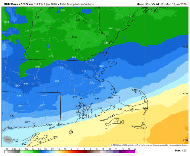
Much of the area could receive between half an inch and one inch of rainfall this weekend. Image provided by WeatherBell.
Thursday night: Becoming partly to mostly cloudy. Low 22-29.
Friday: More clouds than sun, becoming breezy in the afternoon, showers possible towards evening. High 41-48.
Friday night: Cloudy with showers likely, mainly before midnight. Temperatures continue to rise until midnight, then drop to 33-40 by daybreak.
Saturday: Mostly cloudy with rain developing from southwest to northeast, possibly starting as some sleet or freezing rain well north and west of Boston. High 40-47.
Saturday night: Any mixed precipitation changes to all well rain north and west of Boston, periods of rain elsewhere. Low 33-40.
Sunday: Rain ends by midday, mostly cloudy with a few more rain or snow showers possible late in the day. High 38-45.