It’s been a warm and dry summer for most of the region, but the next few days will feature some very hot weather and unlike much of the summer, some extreme humidity.
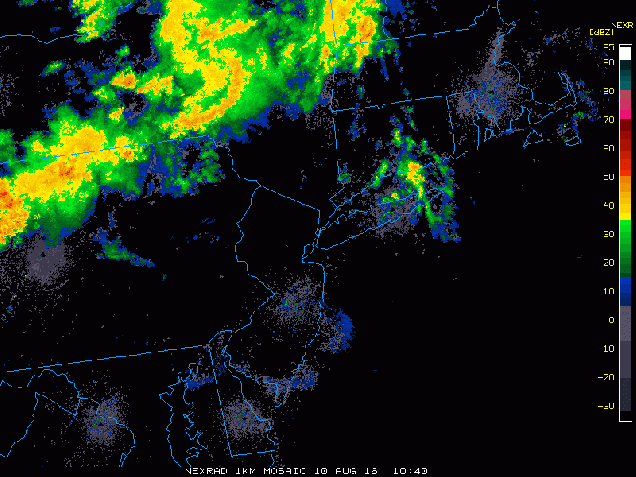
Some much-needed rain fell across Southern New England today. Loop provided by the College of DuPage.
A weak upper-level disturbance moved across the region this morning, bringing some much needed rainfall to the region. The cloud cover and rainfall has kept temperatures mainly in the 70s to lower 80s, but dewpoints have jumped into the upper 60s and 70s across the area. That moisture is going to remain in place for the next several days, but will be accompanied by some very hot weather.
Once some patchy fog burns off Thursday morning, we;ll have sunshine across the area. Since we’re going to start the day in the 70s, temperatures will quickly spike into the 80s and 90s by midday. South to southwest winds will keep temperatures in the 80s along the south coast, but elsewhere, highs will soar well into 90s. When you factor in the humidity, the heat index will be near or just over 100 degrees. As a result, a heat advisory has been issued for much of eastern Massachusetts from Noon until 7pm on Thursday. If your plans include outdoor activities, make sure you follow the usual precautions – drink plenty of liquids and stay out of the sun as much as possible.
Heat index forecast for Thursday afternoon. Image provided by the National Weather Service.
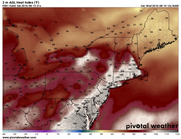
Thursday isn’t the only hot day though, and in fact, it might not even be the hottest day this week. Friday will feature conditions similar to Thursday, but Saturday could be even hotter. Temperatures will soar well into the 90s once again, with heat indices topping 100 across much of the region.
Heat index forecast for 5pm Saturday based on the NAM model. Image provided by Pivotal Weather.
While some showers and thunderstorms may pop up both Friday and Saturday afternoons to provide a little relief from the heat, it’s an approaching cold front that will bring an end to the heat wave. When that front arrives is still a big question mark. Some models want to bring the front through the region Saturday night, while others wait until later on Sunday. This obviously has a big impact on temperatures for Sunday across the region. What the models all agree on is that the front will stall out near the area at some point on Sunday, and then waves of low pressure will ride along the front. South of the front temperatures will still be in the 80s to lower 90s with fairly high humidity, while north of the front temperatures will be in the 70s to lower 80s with lower humidity. The waves riding along the front will likely bring in some beneficial rainfall later Sunday into Monday, before the front finally pushes farther to the south. Neither day should be a washout, but we certainly need the rain. We’ll have more details on that later in the week as things become a little clearer.
(Editor’s Note – This post was originally written for the blog hosted by the University of Massachusetts-Lowell Meteorology Program. This is the reason for the references to Lowell so often. For more information about the UML Weather Center, please visit their homepage at http://storm.uml.edu/)
A Heat Wave. Triple H weather.Bad Hair Days. The Dog Days of Summer. Whatever you like to call it, it’s something we have to deal with every year, though not nearly as much in New England as other parts of the country.
“To be a heat wave such a period should last at least one day, but conventionally it lasts from several days to several weeks. In 1900, A. T. Burrows more rigidly defined a “hot wave” as a spell of three or more days on each of which the maximum shade temperature reaches or exceeds 90°F. More realistically, the comfort criteria for any one region are dependent upon the normal conditions of that region. In the eastern United States, heat waves generally build up with southerly winds on the western flank of an anticyclone centered over the southeastern states, the air being warmed by passage over a land surface heated by the sun.“
How often do we have an actual heat wave here in New England? For Lowell, we average 2 heat waves per year. The most common time for one is between the middle of June and middle of August, but they have occurred as early as the middle of April and as late as late September. In the summer of 1955, we actually had 8 separate heat waves between the end of June and late August. The worst of the bunch was 9 day heat wave that started on June 30 and ended on August 7. On 3 of the 9 days (July 31, August 4, August 5), the high temperature was 100 degrees.
So far, we have not had a heat wave in Lowell in 2016. We had one in 2015, a 3 day stretch from September 7-9, but 2014 also did not feature a 3-day stretch of temperatures above 90.
While a 3-day stretch of 90-degree weather isn’t that uncommon around here, a string of 7 or more days in a row is. In fact, in the 125 years of climate data we have for Lowell, we’ve had a stretch of 7 consecutive days above 90 degrees just 20 times. The last time it happened was just 3 summers ago – July 14-20, 2013. Longer stretches are even rarer. We had a 10-day stretch of 90-degree temperatures from August 27 through September 5, 1953. This occurred just one year after a brutal 13-day stretch from July 11-23, 1952 that featured 4 days with highs above 100 degrees. The worst heat have in Lowell though was a 15-day stretch from August 1 through 15, 1988 which capped off one of the hottest summers in Lowell history.As if having 15-days of 90-degree weather isn’t tough enough, 11 of those days featured highs of 96 or higher, one (August 3) had a high of 100, and most of those days were accompanied by high humidity, with dewpoints well into the 60s and 70s.
While there have been many memorable heat waves in New England, there’s only one day that is known simply as “The Hot Day”. On August 2, 1975, a ridge of high pressure settled into the Northeast. August 1 was hot in its own right, reaching 102 for a high here in Lowell. Temperatures didn’t drop much that night, with the stifling airmass in place. The low temperature on August 2 here in Lowell was only 79, the warmest low temperature on record here. With temperatures already starting the day so warm, and plenty of sunshine, it didn’t take much to send temperatures to levels that had never been seen around here before. On Nantucket, the high hit 100 for the only time on record. Providence, Rhode Island reached 104, setting a new state record. In Massachusetts, a new state record of 107 was set in both Chester and New Bedford. Here in Lowell, our records show a high of 108 was recorded that day, but this seems suspect. High temperatures from other nearby spots that day included 105 in Reading, 103 in Pepperell, 103 in Haverhill, 101 in Lawrence, 100 in Nashua, and 99 in Dracut.
Daily Weather Map for August 2, 1975. Image provided by NOAA.
Luckily, 100-degree heat isn’t common around here. On average, we hit 100 here in Lowell about once every 4 years.The last time it occurred was on July 22, 2011, when we reached 102. In both 1911 and 1952, we reached 100 degrees 5 separate times. 90-degree days occur and average of 14 times per year.So far in 2016, we’ve had 4 days with highs of 90 or higher.1932 is the only year on record in Lowell where the high temperature failed to hit 90 degrees.On the other hand, 1955 saw an incredible 46 days with highs of 90 or higher, just ahead of the 45 such occurrences in 1983.
Whether we hit 90 or not today is still to be determined (the temperature in Lowell was 87 at the time of this being written), but it certainly seems like there are more 90-degree days in our immediate future. The GFS model is showing the possibility of high temperatures in the lower to perhaps middle 90s Sunday and Monday ahead of a cold front, then the possibility of more heat late in the week.
High temperature forecast for Monday July 18 based on the GFS model. Image provided by WeatherBell.
A ridge of high pressure over the Plains states will slowly shift westward over the next few days, with intense heat across the Plains heading for the Desert Southwest.
High temperatures soared well into the 90s across the Southern Plains on Wednesday, but when the humidity was factored in, the heat index exceeded 100-110 degrees in parts of the nation’s midsection. Only a few showers and thunderstorms provided scattered relief to the region. On Thursday, with similar conditions expected across much of the Southern Plains and parts of the Mississippi Valley, heat advisories have been posted for much of the region. High temperatures will be well into the 90s once again with some triple digit readings expected. When the humidity is factored in, heat index values will be in the 100-115 degree range across the region.
Forecast for heat index values for Thursday afternoon. Image provided by WeatherBell
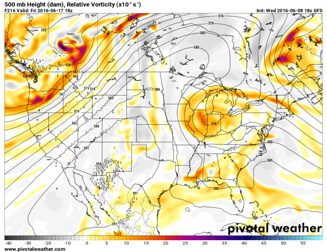
While the nation’s midsection has been enduring the heat, a trough of low pressure has been keeping the West cool for the past few days. Temperatures have been as much as 10 to 20 degrees below normal, especially across the Pacific Northwest. Across the higher elevations of the Cascades, several inches of snow has been reported.
Forecast for 500mb heights for Sunday June 19. Image provided by Pivotal Weather.
While the Northwest will remain cool into the weekend, much warmer weather will move into the Southwest as a ridge of high pressure builds westward. By Saturday, temperatures will be 10-20 degrees above normal in the Desert Southwest. For a place that is “normally” hot, anomalies that big can break records. In Phoenix, high temperatures could approach 120 degrees on Sunday. The record high for that day is 115, set in 1968.
High temperature forecast from the GFS model for Saturday June 18. Image provided by WeatherBell.High temperature forecast from the GFS model for Sunday June 19. Image provided by WeatherBell.
Excessive heat watches have been posted for much of the Southwest from Saturday through Tuesday. The hottest days look to be Sunday and Monday, when high temperatures will likely exceed 110 degrees in Las Vegas, and could approach 120 degrees in Phoenix and Yuma. In Death Valley, California, high temperatures on Sunday and Monday could approach 125 degrees.
Even at night, there will be little relief, as low temperatures may only drop into the 80s to lower 90s across the area. In Death Valley, temperatures may only drop below 100 degrees for a couple of hours.
While temperatures may drop a few degrees later in the week, the ridge of high pressure is expected to remain in place across the Southwest right through the end of the month, keep temperatures above to well above normal.
Here in New England, high pressure will keep us dry and seasonably warm right into the start of next week. Temperatures could get well into the 80s Monday and Tuesday, but no sustained heat is expected for at least the next 10 days.
A large ridge of high pressure will shift from the West Coast into the Nation’s midsection over the next few days, bringing with it some of the hottest weather so far this year to the Plains states.
Temperature anomalies for the past 30 days across the nation. Image provided by WeatherBell.
A persistent ridge of high pressure has been anchored across the West for the past few weeks, keeping temperatures well above normal for much of May and early June. Numerous records were set across the region, even in normally hot locations like the Desert Southwest, where temperatures exceeded 110 degrees several times. In Death Valley, California, which is frequently the nation’s hotspot, the first 8 days of June have averaged 10.6 degrees above normal, with high temperatures exceeding 115 degrees each day.
While the West has been baking, temperatures across the Plains states have been 1 to 3 degrees below normal for the past month. That is about to change as the ridge slides eastward. By the end of the week and the weekend, the ridge will be centered across the Plains and doesn’t look to move that much right through next week.
Map showing heights at the 500mb level across the United states on Sunday June 12. Image provided by Pivotal Weather.
With the ridge of high pressure in place, temperatures will soar well into the 90s across the Plains states and adjacent portions of the Mississippi Valley for much of the remainder of the week, with some triple-digit heat possible across parts of the Dakotas, especially Friday and Saturday.
Some relief will settle into the Northern Plains in the form of a cold front early next week, but the heat will continue from the Southern Plains and Texas eastward into the Southeast. Across these areas, humidity levels will be higher, with dewpoints rising into the 60s and 70s. The result will be heat index values well over 100 degrees across parts of these areas.
High temperature forecast based off of the GFS model for Saturday June 11. Image provided by WeatherBell
The ridge will also act to suppress thunderstorm activity across the Plains states for much of the remainder of the week. Cluster of thunderstorms may develop across the Northern Rockies and ride over the Ridge and into the Great Lakes and eventually the Northeast later in the week. One of these clusters could produce some severe weather across the Eastern Great Lakes and Mid-Atlantic states on Saturday.
While the heat settles in across the Plains temperatures will remain cool across the Northeast. An upper-level low pressure system will only slowly move eastward across southern Canada over the next few days, moving into the Gulf of Maine by early next week. While temperatures surge into the 90s and lower 100s across the Dakotas on Friday, temperatures will only be in the 60s to lower 70s across the Northeast, with parts of Northern New England staying in the 50s. A few showers may pop up during the afternoon, and across some of the higher peaks of the region, some wet snowflakes could mix in with the rain.
There are signs that things could change in New England, but not until the end of next week. Some of the forecast models are indicating the possibility that the upper-level low finally moves out, allowing the heat to finally spread eastward. The latter half of June could feature much warmer conditions if this does come to pass.
Temperature anomalies forecast by the GFS Ensemble for the period June 19 through June 24. Image provided by WeatherBell.