March is the month where we transition from winter to spring, but this week, we’re going to go the opposite direction – from spring to winter.
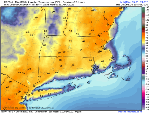
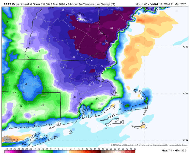
We start the week off with some unseasonably mild weather for Monday and Tuesday with high pressure in control. Temperatures will likely top 60 across inland areas, with 50s or even 40s near the coast and across southeastern Massachusetts, where southwest winds are blowing across the still-chilly Atlantic. By late Tuesday, a backdoor cold front will begin dropping southward as high pressure builds into eastern Canada, meaning a much cooler day is expected, especially along the coast. At the same time, low pressure will be moving into the Great Lakes, so we’ll have plenty of clouds, with a few showers possible during the day, more likely at night. That backdoor cold front will begin to lift northward again as a warm front Wednesday night, but our warm weather redux will be short-lived. The aforementioned low pressure system will drag a strong cold front across the region early Thursday, with rain ahead of it, ending in the afternoon. After a mild start to the day, temperatures will drop during the daytime hours. After a cool day on Friday, another system moves into the Great Lakes, with milder weather returning for Friday night and Saturday before another cold front brings in another round of showers, possibly mixed with some wet snow to start. Another system quickly follows on Sunday, with some additional rain or snow possible.
Monday: Partly to mostly sunny. High 58-65, cooler near the South Coast and Cape Cod.
Monday night: Partly to mostly cloudy across Cape Cod, clear to partly cloudy elsewhere. Low 34-41.
Tuesday: Partly to mostly sunny. High 64-71, cooler near the South Coast and Cape Cod.
Tuesday night: Clear during the evening, then increasing clouds overnight. Low 36-43.
Wednesday: Becoming mostly cloudy and breezy. High 51-58, warmer inland, especially well south and west of Boston.
Wednesday night: Plenty of clouds with some showers likely, breezy. Low 46-53 during the evening, temperatures may rise overnight.
Thursday: Breezy with rain possibly mixed with snow before ending north and west of Boston. High 51-58 early, temperatures drop in the afternoon.
Thursday night: Becoming clear. Low 22-29.
Friday: Morning sun, then increasing clouds, rain or snow showers possible at night, breezy. High 38-45.
Saturday: Breezy with showers ending, some late-day sunny breaks. High 40-47.
Sunday: Partly to mostly cloudy with a chance for rain or snow showers. High 42-49.