Weekly Outlook: March 24-30, 2025

The last full week of March will be a reminder that although it’s now Spring, it won’t always feel that way.

High temperatures are normally close to 50 in late March. Image provided by Weathermodels.com

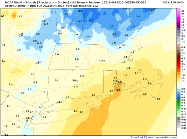
The week starts off with a low pressure system heading across the Great Lakes, sending some rain in for much of the day. However, in the morning, we’ll have just enough cold air in place for some snow, mainly well north and west of Boston, but there won’t be much, if any, accumulation before the change to rain, except possibly in the Worcester Hills and the Monadnocks. That system pulls away, and an upper-level low moves in for Tuesday, resulting in a cool day with clouds, and possibly a sprinkle. Another system will pass by to the south Tuesday night and Wednesday, generating some rain across Cape Cod and southeastern Massachusetts, and possibly a fit farther north and west. There could even be enough cool air in place that if the rain penetrates far enough inland it could change to snow. This is something we’ll be watching over the next day or two. High pressure builds in for Thursday with a sunny and cool day. Another cold front moves in on Friday with a few showers. The weekend looks unsettled at the moment, but full of questions marks. Another low pressure system will head into the Great Lakes, with a warm front extending eastward from it. Ahead of that front we’ll see some precipitation on Saturday, but whether it is rain or snow changing to rain remains to be seen. If the warm front moves through, then, Sunday could be a mild day, but with a cold front moving in from the west, we could see more rain showers before the day is done. If the warm front doesn’t move through, then it will be quite a bit cooler, with the potential for more rain as a wave of low pressure rides along the front to our south.

We could have some snow, rain, or both this weekend as a storm system moves in. Images provided by Pivotal Weather.

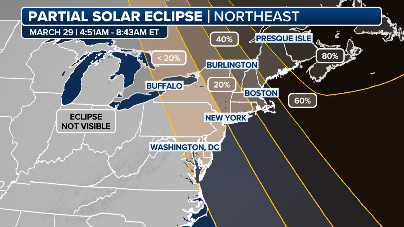
The Saturday morning forecast is of interest for another reason. We will have a partial solar eclipse at sunrise Saturday (around 6:30am), so we’re hoping for clear skies, at least on the eastern horizon. The eclipse will actually reach its maximum before sunrise, but as the sun comes up, it will be 50-70% covered by the moon until the eclipse ends just after 7:00am. We’ll keep an eye on this as the week goes on, but right now, hope for some clear skies and set your alarm to get up early on Saturday for another rare celestial event.

A partial solar eclipse may be visible at sunrise Saturday morning. Image provided by Fox Weather.

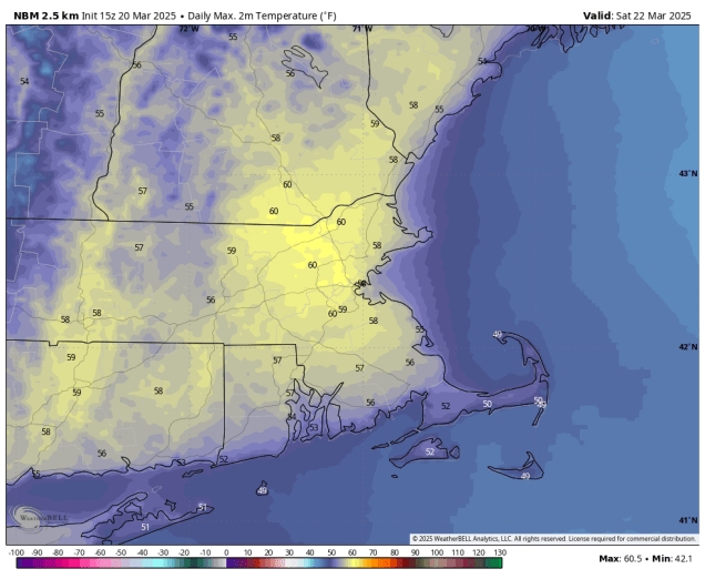
Monday: Cloudy with light rain likely, possibly some morning snow across southern New Hampshire and the Worcester Hills. High 44-51 south of the Mass Pike, 36-43 north of the Pike.

Monday night: Any lingering showers end in the evening, becoming partly cloudy overnight. Low 31-38.

Tuesday: Partly sunny, breezy, chance for a sprinkle. High 47-54.

Tuesday night: Partly cloudy. Low 29-36.

Wednesday: Partly to mostly cloudy, chance for rain across southeastern Massachusetts and Cape Cod, possibly some rain or snow farther inland. High 41-48.

Wednesday night: Clearing. Low 25-32.

Thursday: Sunshine and some afternoon clouds. High 42-49.

Thursday night: Partly cloudy. Low 29-36.

Friday: Partly sunny, breezy, chance for a few showers, mainly early. High 47-54.

Saturday: Partly to mostly cloudy with a chance of rain or snow. High 40-47.

Sunday: Cloudy with a chance of rain. High 41-48.

Weekend Outlook: March 21-24, 2025

Spring began this morning, but that doesn’t mean it’s time to put your winter gear away.

Saturday is shaping up to be the nicest and mildest day of the weekend. Image provided by WeatherBell.

A cold front is making its way toward the region this afternoon, and we’ll see some rain developing ahead of that front tonight. Rain will continue overnight, ending Friday morning as the front moves across the region. We’ll clear out quickly Friday afternoon, with gusty northwest winds ushering some cooler air into the region. High pressure then builds in for Saturday with a milder day, but we’ll see clouds quickly returning ahead of a weak cold front. That front may produce a couple of showers late Saturday afternoon or evening, but most of us will remain dry. Behind it, colder air moves back in for Saturday night and Sunday, despite clear skies. Clouds move right back in Sunday evening, as another system quickly heads our way. This system is a little more complicated. While we’re looking at a chilly, wet day on Monday for much of the region, there may be just enough cold air in place for the rain to start as snow, mainly well north and west of Boston. If it starts before daybreak, we could even see a little accumulation in spots, mainly southern New Hampshire. Any snow should change over to rain during the morning, with periods of rain and showers likely for much of the day.

Could there be a little snow for parts of the region Monday morning? Images provided by Pivotal Weather.

Thursday night: Mostly cloudy with areas of fog, rain developing after midnight. Low 37-44.

Friday: Showers end in the morning, skies start to clear out from west to east in the afternoon, becoming breezy. High 43-50.

Friday night: Clear skies with diminishing winds, some clouds may start to move back in towards daybreak. Low 31-38.

Saturday: Partly sunny, breezy, just a very slight chance for a late-day shower. High 53-60.

Saturday night: Becoming clear. Low 23-30.

Sunday: Mostly sunny, breezy, clouds start to return by evening. High 40-47.

Sunday night: Becoming mostly cloudy, chance for rain towards daybreak, possibly starting as wet snow well north and west of Boston. Low 27-34, temperatures start rising after midnight.

Monday: Mostly cloudy with rain likely, possibly some wet snow early in the day across southern New Hampshire. High 43-50.

Weekly Outlook: March 17-23, 2025

Winter officially ends later this week, but that does not mean that we are done with wintry weather.

Astronomical Spring begins with the Vernal Equinox at 5:01am Thursday. Image provided by EarthSky.org

The week is starting off on a wet, but mild note as a cold front approaches the region. Rain will taper off to showers this morning, ending this evening as the cold front moves through. The airmass behind the front isn’t that cold to begin with, so although we’ll turn cooler, it won’t be that bad. High pressure builds in for Tuesday with some sunshine and temperatures that are closer to where they should be in mid-March. By Wednesday the high will move off to the east, with a wind off the still-chilly Atlantic bringing some cooler air back in along with some clouds. Another system will also be approaching from the west, but this won’t get here until later Thursday, which happens to be the first day of Spring. The Vernal Equinox occurs at 5:01am Thursday, marking the official end of winter. This front will bring in some rain late Thursday and Thursday night. A wave of low pressure will ride up along the front early Friday, bringing in just enough colder air for the rain to change to snow across the interior before ending. Will there be any accumulation? It’s possible, but it’s still a bit early for that, as we’re not even completely convinced yet that the rain will even change to snow. More details on this system will be forthcoming in our Weekend Outlook on Thursday. High pressure builds in with drier weather later Friday and early Saturday, then another weak system passes by to the south later Saturday and Saturday night with some clouds and possibly a shower or two. Drier weather should return on Sunday.

A low pressure system may bring in a little snow around here on Friday. Images provided by Pivotal Weather.

Monday: Rain during the morning, possibly heavy, tapering off to showers during the afternoon. High 52-59.

Monday night: Showers ending from northwest to southeast. Low 32-39.

Tuesday: Gradual clearing. High 50-57, cooler across east-facing coastal locations.

Tuesday night: Clear to partly cloudy. Low 32-39.

Wednesday: Sunny in the morning, clouds start to move back in during the afternoon. High 51-58, cooler across east-facing coastal locations.

Wednesday night: Becoming mostly cloudy. Low 34-41.

Thursday: Cloudy and becoming breezy with showers possible late in the day. High 51-58, cooler across Cape Cod

Thursday night: Showers likely, possibly changing to snow across the interior late at night. Low 32-39.

Friday: Rain or snow ending, breezy. High 41-48.

Saturday: Sunshine and some afternoon clouds, slight chance for a shower at night, breezy. High 49-56.

Sunday: Becoming partly to mostly sunny. High 49-56.

Weekend Outlook: March 14-17, 2025

Some milder weather is on the way once again, but so is some rain.

We could be looking a decent amount of rain Sunday night and early Monday. Image provided by Weathermodels.com

High pressure will remain in control for the next day or two, keeping us on the cool side into Friday, especially near the coast, thanks to east to northeast winds off the chilly Atlantic. We will see some sunshine developing on Friday. Skies may clear out enough tonight to allow you to view the total lunar eclipse, but that is far from a guarantee. As the high moves offshore on Saturday, winds shift into the south and southwest, bringing milder air back in, but also some clouds ahead of a storm system slowly making its way eastward. This storm will produce quite a bit of severe weather from the Mississippi and Ohio Valleys to the Gulf Coast over the next few days, but we’re not expecting that once it moves in. What we are expecting is strong southerly winds on Sunday, possibly gusting to 40-50 mph or higher. This will result in a very mild day away from the South Coast, with temperatures likely getting well into the 60s in many spots. As the cold front trailing the system draws nearer, we’ll see a few showers in the afternoon, becoming more widespread at night, some of them heavy, and some thunderstorms are possible. The front will slow down Sunday night, keeping the rain going into at least Monday morning. Once the front finally pulls away in the afternoon we may see some late-day clearing.

Sunday is looking like a very warm day despite plenty of clouds. Image provided by WeatherBell.

Thursday night: Partly to mostly cloudy. Low 27-34.

Friday: A mix of sun and clouds. High 48-55, a little cooler along the coast.

Friday night: Increasing clouds. Low 32-39.

Saturday: Partly sunny. High 54-61, cooler along the South Coast and Cape Cod.

Saturday night: Mostly cloudy. Low 42-49, temperatures may start to rise after midnight.

Sunday: Plenty of clouds, chance for a shower or two in the afternoon, becoming windy. High 61-68, cooler along the South Coast and Cape Cod.

Sunday night: Cloudy with periods of rain, some of it could be heavy, a thunderstorm is possible, windy at times, especially in the evening. Low 46-53.

Monday: Rain ends in the morning, some clearing late in the day. High 51-58, temperatures may start to drop in the afternoon.

Weekly Outlook: March 10-16, 2025

While much of the upcoming week will be dry, it doesn’t mean the weather pattern is quiet, as we’ll have a few systems moving across the region.

Aside from a few snow or rain showers early Thursday, we’ll stay mostly dry into the start of next weekend. Loop provided by Pivotal Weather.

We’re starting the week off on a dry but mild note with high pressure building in. Temperatures will likely get into the 50s in many areas today with sunshine, and we could top 60 on Tuesday in several locations. A cold front moves through Tuesday night, and though it won’t have much, if any, precipitation with it, it will usher much cooler air in for Wednesday. A weak system moves through Wednesday night and early Thursday with a few snow or rain showers, then temperatures start to turn milder on Friday with high pressure building back in. Southwest winds develop on Saturday ahead of a potent storm in the nation’s mid-section, resulting in a very mild day. Sunday also looks to be breezy and quite mild, but as that storm system moves eastward we’ll have a better chance at some rain, especially later in the day.

Sunday could be a very mild day, but it could be accompanied by some rain. Image provided by WeatherBell.

Monday: Sunshine and a few clouds. High 51-58.

Monday night: A few clouds around. Low 29-36.

Tuesday: Sunshine and some late-day clouds, breezy. High 55-62, cooler across the South Coast and Cape Cod.

Tuesday night: Partly cloudy. Low 26-33.

Wednesday: A mix of sun and clouds, clouds thicken up late in the day. High 40-47.

Wednesday night: Mostly cloudy with a chance for a few snow or rain showers, mainly north of the Mass Pike. Low 28-35.

Thursday: Plenty of clouds with some snow or rain showers possible, mainly in the morning. High 40-47.

Thursday night: Mostly cloudy. Low 29-36.

Friday: Intervals of clouds and sun. High 48-55.

Saturday: More clouds than sunshine. High 56-63, cooler across the South Coast and Cape Cod.

Sunday: Mostly cloudy with showers possible, especially in the afternoon, windy. High 59-66, cooler across the South Coast and Cape Cod.

Weekend Outlook: March 7-10, 2025

The rain and mild temperatures are on the way out, and windy and colder weather is heading back in.

Wind Advisories and High Wind Warnings are in effect for much of the Northeast. Image provided by Pivotal Weather.

The storm that brought us the rain last night is pulling away from the region and the cold front trailing it is offshore, so changes have started. We’ll start to clear out overnight, but northwest winds will start to pick up tonight, ushering cooler air back in. As that storm begins to intensify to our east, we’ll have strong northwest winds on Friday, possibly gusting to 40-50 mph or higher at times. Despite sunshine, it will be much cooler, and the wind will only make it feel even colder than that. We’ll see some clouds move back in on Saturday with a weak disturbance, but aside from a few stray flurries, we should remain dry. Winds will pick back up with this disturbance moving through, but not to the extent of what we’ll have on Friday. High pressure builds in for Sunday with dry and seasonably cool conditions. Another weak system swings through late Sunday night and early Monday with a few rain or snow showers, then we should clear out by afternoon with temperatures starting to moderate once again.

Wind gusts of 40-50 mph are possible across the region on Friday. Image provided by WeatherBell.

Thursday night: Any lingering showers end in the evening, becoming partly cloudy and windy overnight. Low 22-29.

Friday: Sunshine and some afternoon clouds, windy. High 36-43.

Friday night: Partly cloudy, still breezy. Low 25-32.

Saturday: A mix of sun and clouds, slight chance for a snow flurry, becoming windy again. High 33-40.

Saturday night: Clear skies with diminishing winds. Low 20-27.

Sunday: Morning sunshine, increasing afternoon clouds. High 37-44.

Sunday night: Partly to mostly cloudy. Low 24-31.

Monday: A few rain or snow showers possible in the morning, skies start to clear out in the afternoon. High 45-52.

Daylight Saving Time starts at 2am Sunday. Sunset Sunday evening will be at approximately 6:45pm. Image provided by the National Weather Service.

Also, don’t forget that Daylight Saving Time begins this weekend. At 2am on Sunday clocks move ahead 1 hour, and stay that way until November 2.

Weekly Outlook: March 3-9, 2025

It’s still astronomical winter, but March is meteorological spring. In terms of the weather, we’ll experience winter and spring at various times this week.

Temperatures will be about 10 degrees below normal today. Image provided by weathermodels.com

We start the week off with high pressure building in, bringing us plenty of sunshine today, but temperatures will remain quite chilly. As we head into Tuesday, the high slides offshore, and a developing low pressure system in the nation’s midsection will send a warm front our way. This will result in a milder day on Tuesday, but also more in the way of cloudcover and possibly a shower or two late in the day. That system will draw nearer on Wednesday, bringing showers in during the day, with some steadier rain at night, some of which could be heavy. We’ll also have gusty southerly winds, resulting in a very mild day, despite the clouds and rain. A cold front trailing the system will move through on early Thursday, bringing in an end to the steady rain, though a few more showers are still possible during the afternoon. An upper-level disturbance moves across the region Thursday night and early Friday with a few snow showers possible. Another weak system quickly follows on Saturday, but this one will only produce a few snow or rain showers. High pressure builds in for Sunday with dry and colder weather once again.

Temperatures should get well into the 50s on Thursday. Image provided by WeatherBell.

Monday: Plenty of sunshine. High 26-33.

Monday night: Clear during the evening, clouds start to filter in overnight. Low 14-21.

Tuesday: Partly sunny, clouds thicken up late in the day with a stray shower possible, becoming breezy in the afternoon. High 42-49.

Tuesday night: Becoming mostly cloudy. Low 33-40 during the evening, temperatures start to rise after midnight.

Wednesday: Cloudy and breezy with showers likely, steadier rain possible late in the day. High 50-57.

Wednesday night: Windy with periods of rain, tapering off late at night. Low 43-50.

Thursday: Mostly cloudy, a few more rain showers possible. High 52-59.

Thursday night: Partly to mostly cloudy, breezy, chance for a few late-night snow showers. Low 23-30.

Friday: A mix of sun and clouds, chance for a morning snow shower, windy. High 36-43.

Saturday: Intervals of clouds and sun with a few rain or snow showers possible, breezy. High 40-47.

Sunday: Partly sunny. High 35-42.

Weekend Outlook: February 28 – March 3, 2025

“March comes in like a lion and goes out like a lamb”

March isn’t going to come in like a lion this year, but a cheetah might be more accurate, since we’ve got a fast-moving storm system coming in for the start of the month.

A little bit of snow is expected across parts of the region Friday night. Image provided by Weathermodels.com.

High pressure will build in for tonight and much of Friday with drier weather. With temperatures expected to drop below freezing tonight, there could be some icy spots developing on any untreated surfaces, especially ones that don’t see much sunlight during the day. Clouds stream back in late Friday ahead of a fast-moving storm system. We’ll see some light snow developing Friday night, but as milder air moves in, it should change to rain in most places as we get into Saturday morning before it winds down. Accumulations will be minor, if it accumulates at all, with an inch or less for most of us, maybe up to 2 inches in parts of central New Hampshire. Saturday could be another day, with a few breaks of sun developing, but a cold front will move through in the afternoon with some additional rain showers. We’ll clear out behind that front Saturday night, then high pressure builds in with sunshine and much colder weather for Sunday and Monday.

Temperatures at midday Sunday will be 20-30 degrees colder than midday Saturday. Image provided by WeatherBell.

Thursday night: Mostly cloudy with any lingering showers ending in evening, skies start to clear out after midnight. Low 29-36.

Friday: Partly to mostly sunny, clouds start to filter in late in the day, breezy. High 39-46.

Friday night: Mostly cloudy, light snow developing north of the Mass Pike before midnight, rain showers south of the Pike. Snow changes to rain from south to north before daybreak. Low 25-32 during the evening, temperatures rise after midnight.

Saturday: Showers taper off in the morning, some sunny breaks develop, then another round of showers is expected in the afternoon, breezy. High 47-54.

Saturday night: Gradual clearing. Low 13-20.

Sunday: Plenty of sunshine, breezy, and colder. High 24-31.

Sunday night: Clear skies. Low 6-13.

Monday: More sunshine. High 25-32.

Weekly Outlook: February 24 – March 2, 2025

Mostly dry and milder weather is expected to continue across the region for the next few days.

Temperatures will be several degrees above normal this week. Image provided by Weathermodels.com

We start the week off with high pressure moving offshore, allowing for another dry day with temperatures likely topping 40 in many areas. Even milder temperatures are expected on Tuesday ahead of a weak frontal system, which may produce a few widely scattered showers, but most of us will remain dry. Wednesday should be another dry day with temperatures a few degrees cooler. Thursday looks to be the mildest day of this stretch with well above normal temperatures, but it comes at a price. We’ll have a cold front approaching, and it will produce scattered showers across the region, possibly mixed with wet snow if they move in before daybreak. Temperatures start to fall behind it in the evening, so any untreated surfaces could ice up – keep that in mind if you’re heading out Thursday night. Drier and colder air settles in for Friday, though a few widely scattered rain or snow showers can’t be ruled out. As for next weekend, it looks like another low pressure system will move in, but the models don’t agree on much with this system right now, including the timing, amount of precipitation, and type of precipitation to expect. For now, this doesn’t look like it’ll be a potent system, but obviously we’ll keep an eye on it as the week goes on.

A storm system may impact the region later Saturday, but the details are still fuzzy. Images provided by Pivotal Weather.

Monday: Morning sunshine with afternoon clouds. High 38-45.

Monday night: Partly to mostly cloudy. Low 30-37.

Tuesday: Mostly cloudy, slight chance for a late-day shower. High 44-51.

Tuesday night: Slight chance for an evening shower, then becoming partly cloudy. Low 29-36.

Wednesday: Mostly sunny, clouds start to move in late in the day. High 43-50.

Wednesday night: Becoming mostly cloudy, some snow or rain showers possible before daybreak. Low 27-34.

Thursday: Plenty of clouds with occasional showers, breezy. High 46-53.

Thursday night: Mostly cloudy, showers gradually ending. Low 29-36.

Friday: A mix of sun and clouds, chance for a few snow or rain showers, breezy, and cooler. High 38-45.

Saturday: Some early sun, then becoming mostly cloudy with light snow or rain possible during the afternoon and evening, breezy. High 35-42.

Sunday: Intervals of clouds and sunshine and light snow or rain ending, breezy. High 33-40.

Weekend Outlook: February 21-24, 2025

A much quieter weather pattern is expected for the next few days.

A little snow is expected across Cape Cod and the Islands tonight. Image provided by WeatherBell.

A storm system will pass well offshore tonight, but close enough for some light snow and snow showers across Cape Cod and the Islands, and maybe a few flurries into southeastern Massachusetts. Parts of the Outer Cape and Islands could see an inch or two, but otherwise, this is not a problem for most of the region. The system pulls away Friday and high pressure builds in with sunshine along with breezy conditions. This won’t be a repeat of Monday with strong winds and cold temperatures, but it will be a breezy day. Winds will die down Friday evening, setting up a chilly night. A weak upper-level disturbance brings in some clouds later Saturday, but other than a few flurries, we’ll stay dry. Temperatures will slowly moderate over the weekend with high pressure in control. We’ll see more clouds on Monday as another system heads our way, but any rain or snow showers will hold off until nighttime.

Temperatures could top 40 across much of the region on Monday. Image provided by weathermodels.com

Thursday night: Mostly cloudy, light snow or snow showers across Cape Cod and the Islands, a coating to 2 inches possible, a few flurries across southeastern Massachusetts, some clearing late at night. Low 12-19.

Friday: Becoming partly to mostly sunny, breezy. High 25-32.

Friday night: Clear skies. Low 8-15.

Saturday: Sunshine and some late-day clouds. High 29-36.

Saturday night: Partly to mostly cloudy, chance for a snow flurry. Low 15-22.

Sunday: Partly sunny. High 34-41.

Sunday night: Partly to mostly cloudy. Low 17-24.

Monday: Intervals of clouds and sun. High 37-44.