Thanksgiving Weekend Outlook: November 27-December 1, 2025

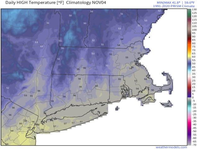
We’ve reached the busiest travel days of the year, and weather should not be an issue for the most part.

Wind chills will be in the upper teens and lower 20s Friday morning. Image provided by WeatherBell.

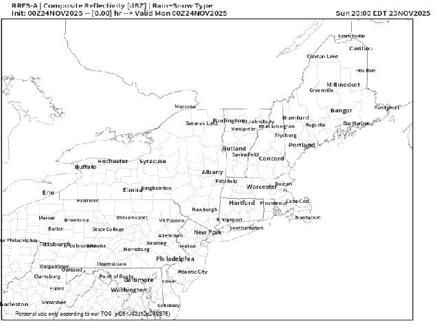
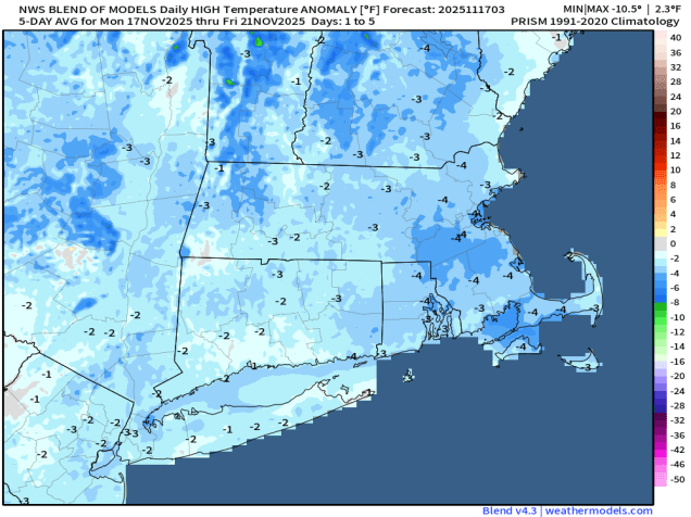
A cold front will cross the region tonight, produce a few showers this evening, then bringing an end to the mild weather we enjoyed today. Blustery and colder weather settles in for Thanksgiving Day, with skies becoming partly sunny. Friday looks to be similar, but a few degrees colder. A few stray snow showers are also possible on Friday, as a weak disturbance may help some of the streams of lake-effect snow survive this far east. High pressure brings sunshine and lighter winds on Saturday, but it will still be quite cool, even by late November standards. Temperatures start to moderate on Sunday as the high shifts off to the east, but the next system will be headed our way with plenty of clouds, and likely some rain by late afternoon. Rain is likely Friday night, ending Monday morning, with some sunshine developing Monday afternoon.

Don’t be surprised if there are some snow showers around Friday afternoon. Loop provided by WeatherBell.

Wednesday night: Plenty of clouds, chance for a few showers during the evening, becoming partly cloudy late at night. Low 35-42.

Thursday: Sunshine and some afternoon clouds, breezy. High 40-47.

Thursday night: Becoming clear. Low 28-35.

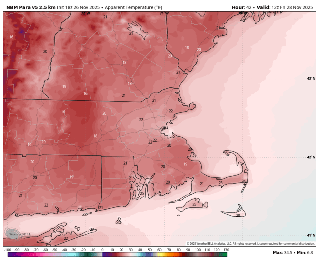
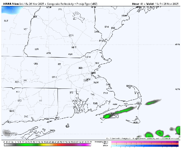
Friday: Partly sunny, chance for a few snow showers, windy. High 36-43.

Friday night: Clear skies. Low 25-32.

Saturday: Plenty of sunshine, breezy in the morning. High 35-42.

Saturday night: Increasing clouds. Low 22-29.

Sunday: Cloudy and breezy with showers developing late in the day. High 44-51.

Sunday night: Showers likely, ending before daybreak. Low 33-40 during the evening, temperatures rise overnight.

Monday: Intervals of clouds and sun. High 42-49.

Weekly Outlook: November 24 – December 1, 2025

Thanksgiving week has arrived and weather shouldn’t cause many issues for travel around here.

Except for some rain Tuesday night and showers Wednesday, weather shouldn’t cause any pre-Thanksgiving travel issues around here. Loop provided by Weathermodels.com

We start to week off with a breezy and cool day as high pressure briefly builds into the region. Winds die down tonight, then we’ll turn milder on Tuesday as winds shift into the southwest ahead of low pressure heading into the Great Lakes. Some rain is likely ahead of that system late Tuesday and Tuesday night, setting up a milder day on Wednesday ahead of an approaching cold front with temperatures possibly approaching 60 in some spots. A few showers are possible during the day, but they’ll be more likely along the front during the evening.

Temperatures could reach 60 around here Wednesday afternoon. Image provided by Pivotal Weather.

Breezy and cooler weather settles in behind the front on Thanksgiving Day, then even colder weather moves in for Friday and Saturday as high pressure builds in. A weak upper-level disturbance may produce a few flurries on Friday, otherwise it’ll just be breezy and chilly with highs only in the 30s to lower 40s, with wind chills in the upper teens and 20s if you’re planning on heading out for any Black Friday sales. Saturday should be dry and chilly once again, but with less wind. Milder air starts to move back in on Sunday, but clouds will also be returning as another system heads our way. It looks like any precipitation accompanying the system should hold off until nighttime, which is good news for what is usually another busy travel day.

Bundle up if you’re heading out for the doorbuster sales Friday morning, as wind chills will be in the upper teens and lower 20s. Image provided by WeatherBell.

Monday: Partly to mostly sunny, breezy at times. High 42-49.

Monday night: Clear during the evening, increasing clouds overnight. Low 28-35, temperatures may rise a little after midnight.

Tuesday: Mostly cloudy, showers possible towards evening. High 47-54.

Tuesday night: Cloudy with showers likely, mainly before midnight. Low 40-47.

Wednesday: Cloudy and mild with a few showers during the day, becoming more likely towards evening. High 53-60.

Wednesday night: Showers ending in the evening, becoming partly cloudy late at night. Low 35-42.

Thursday: A mix of sun and clouds, breezy, turning cooler. High 41-48.

Thursday night: Partly cloudy. Low 28-35.

Friday: Partly sunny, windy, chance for a few flurries. High 36-43.

Saturday: Morning sun gives way to some afternoon clouds. High 34-41.

Sunday: Mostly cloudy. High 39-46.

Weekly Outlook: November 17-23, 2025

Most of the unsettled weather this outlook will happen during the latter half of the week.

Wind chills will be in the 20s when you head out the door Tuesday morning. Image provided by WeatherBell.

The week starts off with low pressure continuing to slowly move away from the region and into Atlantic Canada. The result will be breezy and cool but dry conditions for Monday and Tuesday. A weak system passes south of the region later Wednesday, but high pressure will build in, so we’ll stay dry with lighter winds. Thursday should be another dry and cool day with high pressure in control. A low pressure system will bring some rain and slightly milder air in on Friday, with some gusty winds possible once again as the system pulls away Friday night. High pressure should build in for the weekend with drier and cooler conditions. We will be keeping an eye on a wave of low pressure riding along the cold front as it pushes offshore, but for now, it looks like it will pass too far south to have any impact here.

Temperatures will be below normal for much of the upcoming week. Image provided by Weathermodels.com

Monday: A mix of sun and clouds, windy. High 37-44.

Monday night: Clear skies, breezy. Low 28-35.

Tuesday: Sunshine and a few afternoon clouds, breezy. High 39-46.

Tuesday night: Clear to partly cloudy. Low 25-32.

Wednesday: Mostly sunny. High 40-47.

Wednesday night: Becoming partly to mostly cloudy. Low 25-32.

Thursday: More clouds than sun. High 42-49.

Thursday night: Mostly cloudy. Low 30-37.

Friday: Cloudy with showers likely. High 48-55.

Saturday: Intervals of clouds and sun. High 45-52.

Sunday: Partly sunny. High 42-49.

Weekend Outlook: November 14-17, 2025

Some milder weather is on the way for part of the weekend, but so is some precipitation.

On average, temperatures will remain quite cool through the start of next week. Image provided by WeatherBell.

High pressure builds in with some drier and cooler weather tonight into the first part of Saturday, though we’ll still see some clouds and possibly a rain or snow shower Friday afternoon with an upper-level low nearby. Clouds start to increase later on Saturday as low pressure moves out of the Great Lakes and towards New England. Some rain will move in Saturday evening, but temperatures may be marginally cool enough north and west of Boston for the precipitation to start as a little snow or sleet, before quickly changing to rain as temperatures rise overnight. The rain ends by midday Sunday, then we’ll start to clear out in the afternoon as the system pulls away. As it intensifies in Gulf of Maine, gusty winds will usher cooler air back in later Sunday and Monday.

Rain may start as a little snow or sleet across the interior Saturday night. Image provided by Weathermodels.com

Thursday night: Gradual clearing. Low 28-35.

Friday: Sunshine and some afternoon clouds, slight chance for a sprinkle or snow flurry. High 40-47.

Friday night: Clear skies. Low 25-32.

Saturday: Sunny in the morning, clouds start to move in during the afternoon. High 40-47.

Saturday night: Rain developing, possibly mixed with some snow or sleet at the start from the Merrimack Valley into Southern New Hampshire. Low 31-38 during the evening, temperatures rise overnight,

Sunday: Rain ends in the morning, becoming partly sunny in the afternoon, breezy. High 48-55.

Sunday night: Partly cloudy, breezy. Low 27-34.

Monday: A mix of sun and clouds, windy. High 38-45.

Weekly Outlook: November 10-16, 2025

Much cooler air is on the way for a good chunk of the upcoming week.

When you wake up Tuesday morning, wind chills will be in the 20s. Image provided by WeatherBell.

A strong cold front will move across the region today, while a developing wave of low pressure rides up along that front, bringing some more rain in, especially during the morning and early afternoon hours. It’ll be mild ahead of the front in the morning, but much cooler air will quickly move in behind the front during the afternoon and evening. How cool are we talking? High temperatures on Tuesday will only be in the upper 30s and lower 40s, but it will be breezy, so wind chills will only be in the 20s and 30s. Yes, we’re talking about wind chills. It’s that time of year. A large upper-level low pressure area will then make its way into the region. While this will bring much cooler air into our area, some records may be set in parts of the Southeast, as temperatures may drop to freezing or below all the way to the Gulf Coast. With the upper low nearby we’ll still have some clouds around with a few showers or flurries possible. Yes, snow flurries. Really. The upper low will drift into Atlantic Canada for the middle to latter portion of the week and into the weekend and high pressure will try to build in, but we’ll still have a few disturbances moving through at times, generating some additional clouds along with a few rain or snow showers, while keeping temperatures below normal for mid-November.

Temperatures will be 5-10 degrees below normal for much of the week. Image provided by Weathermodels.com

Monday: Occasional showers, some periods of steadier rain at times. High 54-61.

Monday night: Showers end in the evening, becoming partly cloudy to clear. Low 28-35.

Tuesday: Some morning sun, then clouds return, a few rain or snow showers are possible, breezy. High 36-43.

Tuesday night: Partly to mostly cloudy. Low 28-35.

Wednesday: More clouds than sun, breezy, chance for a few rain or snow showers. High 41-48.

Wednesday night: Partly cloudy. Low 32-39.

Thursday: Partly sunny, breezy, a few showers possible. High 44-51.

Thursday night: Clear to partly cloudy. Low 29-36.

Friday: A mix of sun and clouds, breezy. High 42-49.

Saturday: Partly to mostly sunny. High 39-46.

Sunday: Partly sunny. High 42-49.

Weekend Outlook: November 7-10, 2025

An active weather pattern will remain in place, but big changes are on the way in the temperature department.

Systems keep moving through every couple of days. Loop provided by Tropical Tidbits.

High pressure builds in tonight with skies clearing out and winds diminishing, resulting in a rather chilly night, with much of the region likely dropping below freezing. Clouds quickly return on Friday as a frontal system heads our way. Winds shift into the southwest ahead of the system, so it’ll be a milder day. The front brings in some showers Friday night, ending early Saturday morning, with some clearing in the afternoon. Once again, temperatures could top 60 in many places if we can get enough sun during the afternoon.

Saturday is looking like a rather mild day. Image provided by WeatherBell.

Clouds quickly return on Sunday as another system heads into the Great Lakes. We’ll see rain developing Sunday afternoon, continuing into Sunday night as a secondary area of low pressure develops and passes close to or across Cape Cod. As that system moves into the Gulf of Maine on Monday it will intensify, bringing an end to rain. Gusty northwest winds behind the system will usher much cooler air into the region for the first part of next week.

Much cooler weather is on the way for next week. Image provided by Weathermodels.com

Thursday night: Becoming clear with diminishing winds this evening, a few clouds move back in late at night. Low 26-33.

Friday: Becoming partly to mostly cloudy, breezy in the afternoon. High 51-58.

Friday night: Cloudy, breezy during the evening, showers developing. Low 45-52 during the evening, temperatures rise a little overnight.

Saturday: Morning showers, then becoming partly to perhaps mostly sunny in the afternoon. High 56-63.

Saturday night: Partly cloudy. Low 36-43.

Sunday: Becoming mostly cloudy, rain develops in the afternoon. High 52-59.

Sunday night: Cloudy with showers likely. Low 41-48.

Monday: Mostly cloudy with showers gradually ending. High 52-59.

Weekly Outlook: November 3-9, 2025

The weather pattern will turn a bit more active this week.

Average high temperatures in early November are in the mid-50s. Image provided by Weathermodels.com

We’re starting off dry today as high pressure slides offshore, but there are two systems heading our way. Low pressure heading up the East Coast will pass by the region later today, producing some light rain across parts of eastern Massachusetts and Rhode Island. At the same time, another system crossing southeastern Canada will send a cold front our way, with some additional rain showers across much of the region tonight. Behind the front, breezy and cooler conditions are likely as high pressure builds in for Tuesday. Another system quickly follows for late Wednesday and Wednesday night, with another round of rain showers, with gusty winds likely behind the system on Thursday. High pressure builds back in, and as it moves eastward, winds will shift into the southwest on Friday, allowing milder air to move back in. It will be short-lived though, as another cold front brings in some showers for Friday night. Saturday should be another dry and cooler day, but yet another system follows on Sunday with another round of showers expected.

Storms will move through the region every other day this week. Loop provided by Pivotal Weather.

Monday: Becoming mostly cloudy with showers developing in the afternoon, mainly across eastern Massachusetts and Rhode Island. High 53-60.

Monday night: Showers end in the evening, skies clear out after midnight, breezy. Low 39-46.

Tuesday: Plenty of sunshine, breezy. High 50-57.

Tuesday night: Clear to partly cloudy. Low 36-43.

Wednesday: Increasing clouds. High 53-60.

Wednesday night: Cloudy and becoming breezy with scattered showers. Low 38-45.

Thursday: Becoming partly to mostly sunny, breezy. High 47-54.

Thursday night: Partly cloudy. Low 28-35.

Friday: Partly sunny in the morning, then clouds thicken up, showers possible at night. High 51-58.

Saturday: Morning showers, then clouds give way to some afternoon sun. High 54-61.

Sunday: Partly to mostly cloudy with a chance for more showers. High 52-59.