There’s a four letter word that begins with the letter R and rhymes with main that we really need, but you won’t find it in our forecast for the next week.

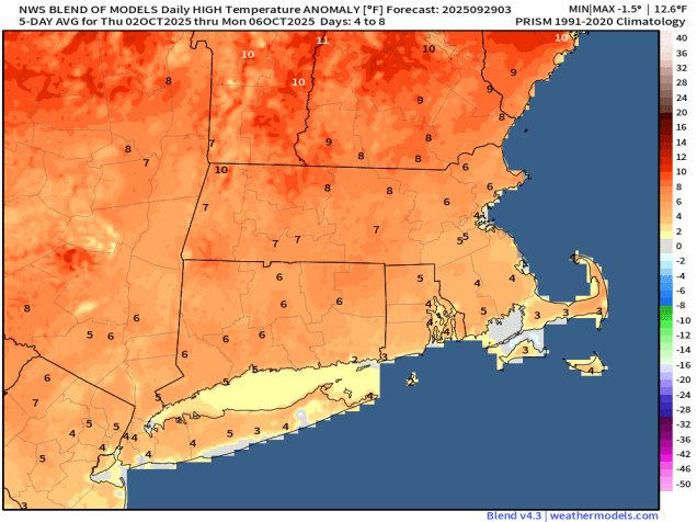
The week starts off with high pressure in control, keeping us rather mild for the end of the September. A cold front will move through on Tuesday, but only a few clouds will accompany it. Behind it, strong high pressure builds in with gusty north to northeast winds bringing much cooler air in for Wednesday and Thursday. Meanwhile, with Hurricane Humberto and Tropical Storm Imelda well offshore (more on them in a moment), the gradient between the large high and those systems will result in gusty winds towards the middle of the week. By the end of the week and the weekend, the high will slide off to the south, keeping us dry, but with temperatures getting back to near to above normal levels.
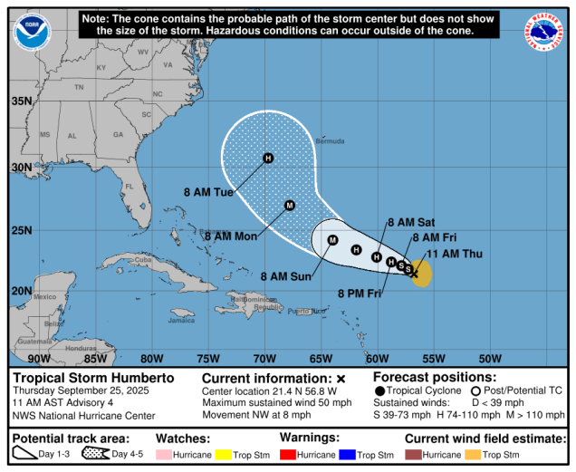
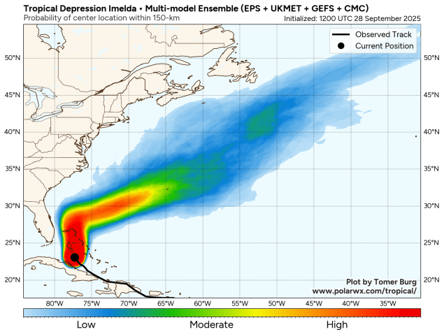
Meanwhile, as previously mentioned, we have both Hurricane Humberto and Tropical Storm Imelda in the Atlantic at this time. While both storms could bring some adverse weather to Bermuda over the next few days, and they will both generate rough surf for the East Coast, they should both stay offshore, much to dismay of the Facebook Forecasters everywhere who were tossing around phrases like “Fujiwara Effect” without actually understanding what it meant.

As of 2am Monday, Hurricane Humberto was centered about 400 miles south-southwest of Bermuda, moving toward the northwest at 14 mph. After reaching Category 5 strength over the weekend, the storm was still a Category 4 system with maximum sustained winds near 140 mph. Humberto should turn northward passing west of Bermuda Monday night and Tuesday before turning northeastward. Humberto may produce some gusty winds and heavy rain across Bermuda, which is why a Tropical Storm Watch has been issued. By Wednesday, Humberto will transition into an extratropical storm as it heads east-northeastward into the open waters of the Atlantic.

Closer to the East Coast is Tropical Storm Imelda, crossing the Bahamas early this morning while moving northward at 8 mph. Imelda has maximum sustained winds near 45 mph, and has been very slow to get organized. It will continue to bring squally conditions to the northwestern and central Bahamas on Monday where a Tropical Storm Warning remains in effect. As Imelda heads northward, some heavy rain may impact coastal portions of the Carolinas. By Tuesday, the storm should make a hard right turn and pull away from the coast, while strengthening, possibly becoming a hurricane by midweek. The current forecast calls for Imelda to pass very close to Bermuda Wednesday night or Thursday as a hurricane, making for a very rough week for the British Overseas Territory. After that, it should also become an extratropical storm over the open waters of the Central Atlantic.
Monday: Sunshine dimmed by some afternoon high clouds. High 73-80.
Monday night: Partly to mostly cloudy. Low 54-61.
Tuesday: Partly sunny. High 70-77.
Tuesday night: Clear to partly cloudy, becoming breezy. Low 44-51.
Wednesday: Mostly sunny, breezy, cooler. High 59-66.
Wednesday night: Clear skies, breezy along the coast. Low 38-45.
Thursday: Plenty of sunshine, breezy in the morning. High 57-64.
Thursday night: Clear to partly cloudy. Low 38-45.
Friday: More sunshine, milder. High 64-71.
Saturday: Sunny. High 70-77.
Sunday: Sunshine and a few clouds. High 74-81.