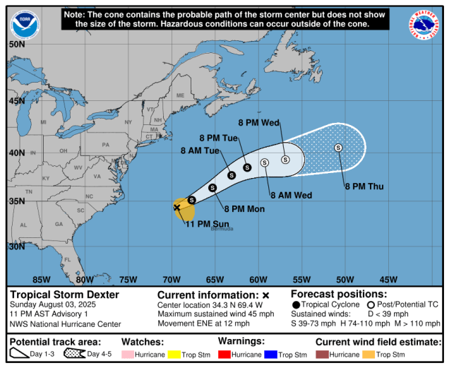
The forecast for most of the upcoming week will be a fairly simple one for our region. Meanwhile, Tropical Storm Dexter has developed in the Atlantic well off the East Coast, but it won’t have any impact here.

High pressure will dominate our weather for most of the upcoming week, with mostly sunny skies, seasonably warm temperatures, and comfortable humidity levels. Today will likely be the warmest day, with some places across the interior approaching 90, but the rest of the week will feature temperatures mainly in the upper 70s and 80s across the interior, with seabreezes keeping coastal areas a little cooler. We could see a few pop-up showers and thunderstorms well inland towards midweek, but for the most part, it will remain dry into next week. Some smoke in hazy conditions at times, mainly during the first half of the week.

The only real question mark in the forecast is Sunday. As we mentioned in the previous blog about the tropics, we need to keep an eye on a potential system developing near the Southeast coast later this week. Some models bring the system into the Southeast or Carolinas, with some of the moisture drifting northward towards next weekend. Some models try to bring the system itself up the coast as the high shifts off to our east. Of course, this system may not even develop, and the entire point would be moot. Right now, it looks like the high may be strong enough to keep us dry, but also turning hot once again. We should have a much better idea when we get to our Weekend Outlook later this week.

Tropical Storm Dexter developed late Sunday night off the East Coast. It was centered about 300 miles west-northwest of Bermuda, moving toward the east-northeast at 12 mph. Maximum sustained winds were near 45 mph. Dexter may strengthen a little more on Monday, but not much, as wind shear will remain in place. Beyond that, wind shear will take more of a toll on the system, and it will likely lose its tropical characteristics by midweek as it continues east-northeastward into the open waters of the Atlantic. It may churn up some rough seas and create some rip currents along the East Coast later this week, but that should be its only impacts.

Monday: Sunshine filtered through haze and smoke. High 84-91, a little cooler across the South Coast and Cape Cod.
Monday night: Partly cloudy. Low 61-68.
Tuesday: A mix of sun and clouds, hazy, a shower or thunderstorm possible well inland. High 77-84, a little cooler along the coast.
Tuesday night: Partly cloudy. Low 57-64.
Wednesday: Partly sunny, hazy, slight chance for a stray shower well inland. High 75-82, coolest along the coast.
Wednesday night: Partly cloudy. Low 58-65.
Thursday: A mix of sun and clouds. High 76-83, coolest along the coast.
Thursday night: Clear skies. Low 56-63.
Friday: Sunshine and a few clouds. High 78-85, coolest along the coast.
Saturday: Mostly sunny. High 82-89, a little cooler across the South Coast and Cape Cod.
Sunday: A mix of sun and clouds. High 86-93, a little cooler across the South Coast and Cape Cod.