Did Someone Say Snow?

We haven’t had much of the flaky white stuff yet this winter, but that’s going to change on Friday.

Very little snow has fallen across much of the region so far this winter. Image provided by Weathermodels.com

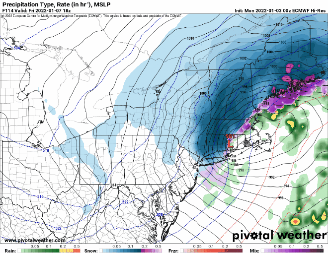
A low pressure area currently moving across the Pacific Northwest will make its way across the country over the next 24-36 hours, moving off the Mid-Atlantic coastline Thursday night, passing south and east of New England Friday morning. The system will be moving fairly quickly, and while it will become a rather potent storm as it heads into Atlantic Canada, it won’t be that strong when it passes New England. This means that we’re looking at a light to perhaps moderate snowstorm across the region on Friday. For the most part, this will be mostly snow across the region, with any rain mixing in likely confined to the Outer Cape and Islands. With this in mind, a Winter Storm Watch is in effect on Friday from 1am until 1pm for all of Rhode Island and southeastern Massachusetts (not including Cape Cod) as well as the Boston area

The ECMWF shows the quick progression of the storm Thursday night and Friday. Loop provided by Pivotal Weather.

First, we’ll talk about the timing, which isn’t optimal. The snow will likely develop across the region between 3 and 5am, which means it will have a significant impact on the morning commute. For the most part, the snow will be light, but there will be a few embedded steadier bursts of snow through the morning. The snow should wind down and end between 12 and 3 pm, so it could have an impact on the afternoon commute, but the roads should be in good shape by that point as long as crews have been keeping up with it all day.

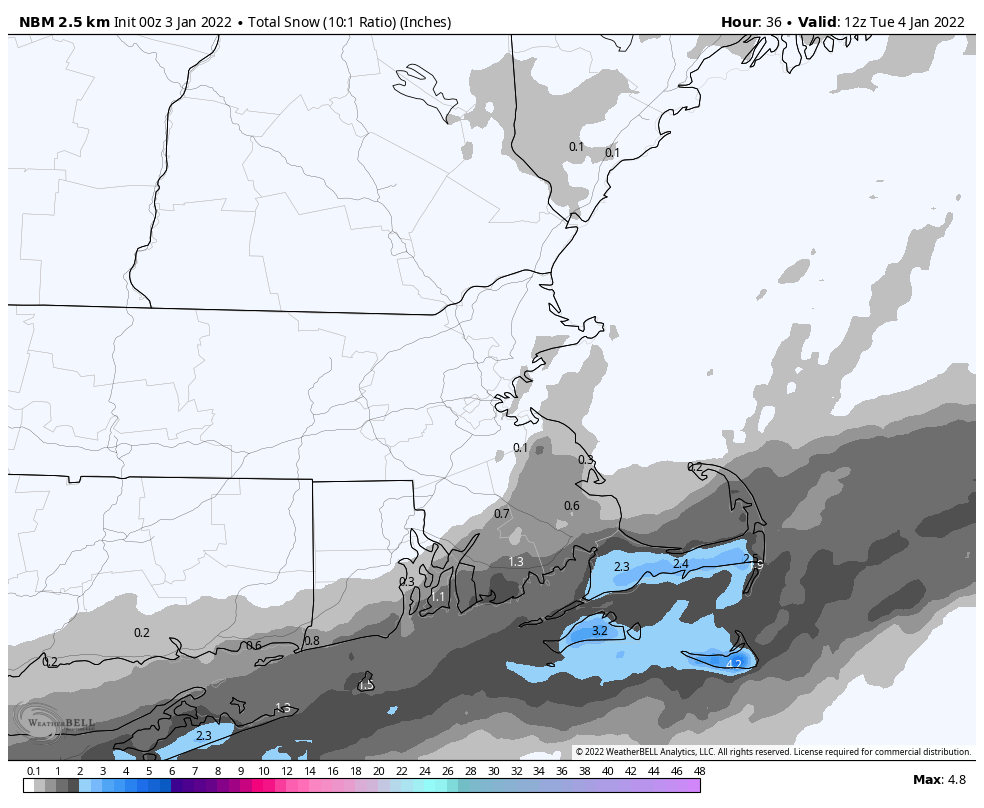
As for how much to expect, as we already mentioned, this won’t be a big deal. However, since it’s the first real widespread accumulating snow of the winter, it’ll turn into a bigger deal than it probably should be. Here’s our thinking:

Southern NH: 1-3″
NH Seacoast/Merrimack Valley: 2-4″
I-95 corridor: 3-5″
Southeastern Mass/RI: 4-7″
Upper Cape Cod: 3-5″
Outer Cape/Islands: 1-3″

The National Weather Service forecast is fairly close to ours, maybe a tad higher. Image provided by WeatherBell.

Saturday looks to be sunny but chilly, with another system bringing milder air and rain back in later Sunday into early Monday. However, it’s looking more and more like a brief but significant cold shot is coming for Tuesday/Wednesday next week. We’ll provide an update on the snow forecast in our Weekend Outlook tomorrow.

Weekly Outlook: January 3-9, 2022

A rather active pattern is expected to continue for this week, with some snow for parts of the region, possibly more than once.

The week starts off with low pressure passing south of the region today. It will be close enough to spread some light snow into the Cape and Islands, and possibly southeastern Massachusetts. Any accumulations will be confined to the Cape and Islands, with Nantucket and Martha’s Vineyard possibly seeing a few inches. For the rest of us, it’ll be a cloudy and chilly day. Many places won’t get out of the 20s, and wind chills will be in the teens, so keep that in mind if you’ll be outside for any length of time today. We’ll clear out tonight as the system pulls away, then high pressure builds in with sunshine and seasonably cool conditions on Tuesday. We’ll start to warm up again on Wednesday, but also will have plenty of clouds and some showers ahead of another cold front. That front moves through early on Thursday, bringing an end to the showers, and ushering cooler air back in. After that, things get very uncertain.

Most of the snow today will be confined to the Cape and Islands. Image provided by WeatherBell.

Some of the models have been hinting at the potential for coastal storm in the Thursday night/Friday time frame for quite some time now. However, since the models have downright awful beyond about 2-3 days, we haven’t bothered to look at the details too much, but have noted the potential. Well, it’s 5 days away now, and there is still plenty of disagreement as to what could happen, or if there will even be a system to affect the region. We’re of the belief that there will be a system, and it could produce some snow across at least inland locations. Beyond that, we’re not prepared to go into much more detail yet (though some of the usual internet trolls will probably be more than happy to find maps from models that show heavy snow and will share them all over Facebook and Twitter). Obviously, we’ll have a better idea as we get towards mid-week, and will elaborate more at that point, if needed.

Storm or no storm on Friday? It depends on which model you believe, if any of them. Images provided by Pivotal Weather.

High pressure builds in for Saturday with dry and chilly conditions, then another system could bring in some snow or rain showers for Sunday.

Monday: Plenty of clouds, snow showers likely across the Cape and Islands. High 25-32.

Monday night: Clearing and cold. Low 11-18.

Tuesday: Mostly sunny. High 29-36.

Tuesday night: Increasing clouds. Low 20-27.

Wednesday: Mostly cloudy, breezy, mild, chance for showers. High 45-52.

Thursday: Partly sunny. High 35-42.

Friday: Cloudy and breezy with a chance of snow or rain. High 32-39.

Saturday: Mostly sunny. High 26-33.

Sunday: Mostly cloudy with some snow or rain showers possible. High 37-44.