While everything around comes to a grinding halt, the weather does not, which means that here at StormHQ, The Show Must Go On. This week, that will be a variety show.
We start the week off with high pressure in control, so we’ll have a sunny but rather chilly Monday. The dry weather won’t last much longer though, as the high moves offshore and a disturbance moves into the Great Lakes. This will bring some precipitation in for Tuesday. While most of us will just see some rain, there could be some wet snow mixed in at that start Tuesday morning across southern New Hampshire. We’re not expecting any accumulation, and despite what this winter has been like, this is a fairly normal occurrence in mid-March. The rain ends late in the day and high pressure builds back in with sunshine and seasonable conditions returning for Wednesday.
The latter half of the week isn’t looking that great right now. We’re not expecting any big storms, but a series of smaller ones. The first one moves in for Wednesday night and Thursday. With some cold air in place, this one may start as snow for much of the area (except southern areas), but should change over to rain during the morning. If there’s any accumulation (and it is a possibility this time), it will be most likely across grassy areas and at elevation. Would we be surprised if we end up with some coatings from southern New Hampshire into the northern and western suburbs of Boston? Of course not. In fact, one model shows the potential for a lot more than just coatings. if the trend continues that way, we’ll do a special update later in the week.
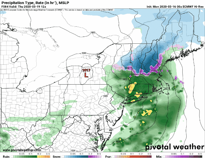
The rain ends during the Thursday evening, but another storm quickly follows. This one will move across the Great Lakes, with significantly milder air expected on Friday. Of course, it will be accompanied by rain, but it’s not like you can do much to head out an enjoy it anyway, right? The rain ends Friday night as a cold front moves through, then high pressure builds in next weekend with sunshine and colder weather once again.

Monday: Sunshine fades behind increasing and thickening afternoon clouds. High 34-41.
Monday night: Mostly cloudy. Low 26-33, but temperatures may hold steady or drift up a few degrees after midnight.
Tuesday: Cloudy with showers likely, possibly starting as some wet snow across southern New Hampshire. High 44-51.
Tuesday night: Becoming clear. Low 27-34.
Wednesday: Sunshine gives way to afternoon clouds again, snow develops late at night, except rain along the South Coast. High 43-50.
Thursday: Cloudy with snow changing to rain, ending by evening. Some accumulation is possible, mainly well north and west of Boston. High 43-50.
Friday: Cloudy, breezy, and quite mild with showers redeveloping. High 62-69.
Saturday: A cloudy start, then skies become mostly sunny, breezy. High 43-50.
Sunday: Partly to mostly sunny. High 36-43.
