Well, now that we’ve had our first snow of the year, who’s ready for more? Yup, there’s snow on the way for parts of the region. After that, everyone can expect some frozen turkey for Thanksgiving. Let’s get right to the details.
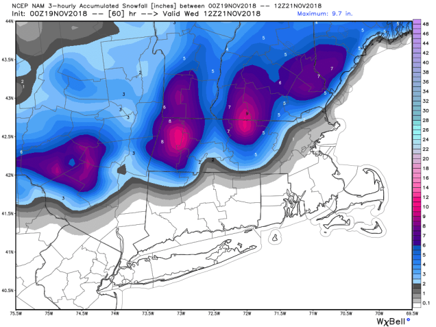
We start the week off with a fairly benign system moving across the region. Any rain or snow showers will end towards midday. The clouds will remain in place as another system will quickly follow. This system will be a little more potent tonight into Tuesday. It will also be a lot more complicated. Precipitation will redevelop around midnight. If you live north and west of 495, the precipitation will likely be in the form of snow. For the rest of us, it’ll start as rain. The precipitation will continue into the morning, then by late morning, the rain/snow line will start to sag southward towards the Boston area. Everything should wind down by early afternoon. Snow accumulations will range from a dusting in the Boston area, to a couple of inches north and west of Boston, to 3-5 inches from the Merrimack Valley into Southern New Hampshire.
This brings us to Wednesday. An arctic cold front will cross the region. This front may be accompanied by some snow showers or squalls during the afternoon hours. Behind the front, we’re looking at the coldest air so far this fall for Thanksgiving Day. Low temperatures in the teens, possibly even some single numbers in the cold spots, may set new record lows. If you’re heading out to a high school football game, you’d better bundle up, since wind chills will be in the single numbers or below zero. We’ll have plenty of sunshine during the afternoon, but it won’t help that much, as high temperatures will be stuck in the 20s for most of us. Thursday night will also be quite cold, so keep that in mind if you’re going to wait outside for Black Friday sales.

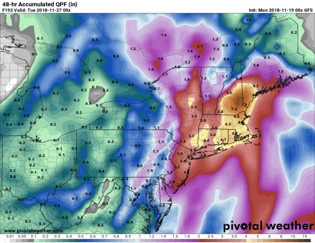
Don’t worry, the cold shot will be brief as we’ll see temperatures start to moderate for Friday and Saturday as high pressure slides offshore. The next storm system moves in for Saturday night and Sunday. Unlike the last couple, this one should be mostly rain. In fact, it might be a lot of rain. But, at least it’ll be rain, not snow, right?
Monday: Cloudy with some snow or rain showers during the morning. High 38-45, except 46-53 across southeastern Massachusetts and Rhode Island.
Monday night: Rain redeveloping inside I-495, snow north and west. Low 30-37.
Tuesday: Rain changing to snow, ending late in the day. Accumulations less than 1″ in Metro Boston, 1-3″ north and west of Boston, 2-4″ in the Merrimack Valley and the NH Seacoast, and 3-5″ in southern New Hampshire. High 33-40 early, warmer across southeastern Massachusetts. Temperatures slowly drop during the afternoon.
Tuesday night: Becoming partly cloudy. Low 20-27.
Wednesday: A mix of sun and clouds, becoming breezy. Some snow showers or squalls are possible late in the day. High 33-40.
Thanksgiving: Mostly sunny, breezy, and cold. High 18-25.
Friday: Mostly sunny. High 25-32.
Saturday: Increasing clouds, rain develops at night. High 40-47.
Sunday: Breezy with rain, possibly heavy. High 45-52.
