Some stormy weather is on the way, and it may not be just rain for at least a part of the region.
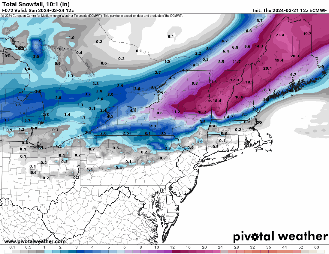
High pressure builds in for tonight and the first part of Friday with clear skies, diminishing winds, and chilly conditions. Clouds start to move back in late Friday ahead of a pair of systems. The first, a weak upper-level disturbance moving out of the Great Lakes will bring in some light precipitation before daybreak Saturday. With chilly weather in place, it may start as snow north and west of Boston, with rain to the south. The snow should change to rain before midday, but some minor accumulations are possible, mainly from the hills of Worcester county into the Monadnocks, but also across parts of Southern New Hampshire, where an inch or two is possible. The second system, a stronger low pressure area will move up the East Coast, bringing in some steadier and likely heavier rain late Saturday into Saturday night. Many of the models are showing the potential for 1-3 inches of rain, which could result in some areas of flooding. The storm pulls away early Sunday, but we need to keep an eye on a second area of low pressure that will develop off the Carolina coast on Sunday. It will likely stay too far offshore to have any appreciable impact on the region, but as it meanders around offshore, it could send in some clouds and possibly a few showers to Cape Cod and southeastern Massachusetts later Sunday into Monday. Otherwise, high pressure builds in with dry and cool conditions.
Thursday night: Clear skies, breezy during the evening, winds diminish overnight. Low 19-26.
Friday: Sunshine and some afternoon clouds. High 37-44.
Friday night: Becoming cloudy, light snow possible late at night north and west of Boston, light rain elsewhere. Low 28-35 during the evening, temperatures rise a little after midnight.
Saturday: Windy with snow changing to rain north and west of Boston, rain likely elsewhere, heavy at times in the afternoon. High 47-54 south of the Mass Pike, 39-46 north of the Pike.
Saturday night: Windy with rain ending by midnight, possibly mixed with a few wet snowflakes north and west of Boston. Low 25-32.
Sunday: Partly to mostly cloudy, windy, chance for a few snow or rain showers across parts of Cape Cod and the Islands. High 37-44.
Sunday night: Partly to mostly cloudy, windy, slight chance for a shower across the Outer Cape and Nantucket. Low 24-31.
Monday: Intervals of clouds and sun, windy. High 37-44.
