Weekly Outlook: March 16-22, 2026

The week is going to start off with a potent storm system heading our way.

A couple of batches of rain are likely today and tonight, maybe even some thunderstorms. Loop provided by Weathermodels.com

The low pressure system bringing blizzard conditions to the Great Lakes will impact us over the next 36 hours, but not with blizzard conditions. A warm front extending eastward from the system will cross the region today, with some rain ahead of it through the morning hours. Once the front moves through, gusty southerly winds will bring milder air back in, but the rain will taper off to some widely scattered showers. However, steadier and heavier rain will return by evening as a cold front begins to approach from the west. A line of thunderstorms may accompany the front tonight, though any severe weather will likely be well to our south. Rain ends by daybreak Tuesday as the front pushes offshore, with gusty west winds behind the front bringing much colder air back in. While we’ll start to clear out in the morning, a secondary cold front will bring some clouds back in during the afternoon, with a few stray flurries possible.

Temperatures will get into the 60s across much of the region Monday evening ahead of the cold front. Image provided by WeatherBell.

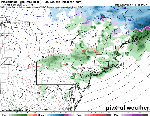
High pressure builds in with dry and chilly conditions for Wednesday, but as it slides off to the east, temperatures will start to moderate for Thursday and Friday. Another system may move in for the weekend, but there is a lot of uncertainty with this storm, with some rain or snow possible, depending on the eventual evolution of the system. We should have more clarity by the time we get to our Weekend Outlook on Thursday.

The models all have different ideas about a potential storm next weekend. Images provided by Pivotal Weather.

Monday: Cloudy and becoming windy with rain during the morning, tapering off to occasional showers during the afternoon. High 55-62.

Monday night: Windy with rain redeveloping, possibly heavy at times, some thunderstorms are possible. Rain ends before daybreak. Low 34-41.

Tuesday: Becoming partly sunny, breezy, chance for a few late-day flurries. Temperatures hold steady or drop during the daytime.

Tuesday night: Clear skies, diminishing winds. Low 19-26.

Wednesday: Morning sunshine with afternoon clouds. High 32-39.

Wednesday night: Cloudy during the evening, some clearing after midnight. Low 22-29.

Thursday: Partly sunny. High 38-45.

Thursday night: Partly cloudy. Low 27-34.

Friday: A mix of sun and clouds. High 44-51.

Saturday: More clouds than sunshine, breezy, chance for some snow or rain. High 43-50.

Sunday: Partly to mostly cloudy, breezy, some snow or rain is possible. High 38-45.

Weekend Outlook: December 19-22, 2025

Astronomical Winter begins at 10:03am Sunday, but until then, Mother Nature can’t decide which season we’ll get to experience.

Temperatures will get well into the 50s on Friday. Image provided by Weathermodels.com

A low pressure system that prompted blizzard warnings in the Dakotas today will quickly move into southeastern Canada by tomorrow. Don’t worry, we’re not expecting blizzard conditions around here, but some heavy rain and strong winds are a lot more likely. With the system passing to our north, we’ll be in the warm side, and southwest to southerly winds will increase ahead of a cold front trailing the system. As the clouds move in later today and tonight the increasing winds will allow temperatures to rise for much of the night, climbing well into the 50s. The rain moves in after midnight, and it could be briefly heavy Friday morning. South winds of 20-30 mph, gusting to 50 mph at times will bring in unseasonably warm air, with some places possibly reaching 60. The cold front comes marching through around midday, quickly bringing an end to the rain. As winds shift into the west they will diminish a little, but will also usher much cooler air in, with temperatures quickly dropping into the 40s and 30s by evening. There could be a few rain or snow showers as the colder air rushes in, but for the most part, once the front moves through we’ll dry out. The gusty winds will also help to dry out the roads, so black ice shouldn’t be a problem Friday night and early Saturday, but you should probably use some caution if you’re heading out.

Wind gusts of 40-50 mph are expected on Friday, a little stronger on Cape Cod. Image provided by WeatherBell.

We’ll clear out and turn colder for Friday night and Saturday, but clouds quickly stream back in Saturday afternoon and evening. Another weak system passes by to our north, but it doesn’t look like it’ll be accompanied by much, if any precipitation Saturday night and Sunday. It will bring in some milder weather once again, as temperatures get back into the 40s Sunday afternoon. Skies clear out behind that system later Sunday, with gusty west winds bringing cooler air back in for Sunday night and Monday as high pressure builds back in.

Temperatures Saturday morning will be 25-35 degrees colder than they were at the same time Friday morning. Image provided by WeatherBell.

Thursday night: Becoming mostly cloudy and breezy with rain developing after midnight. Low 33-40 during the evening, temperatures rise overnight.

Friday: Cloudy and windy with rain, possibly heavy in the morning, ending in the afternoon. High 52-59, temperatures start dropping quickly in the afternoon.

Friday night: Chance for a few rain or snow showers during the evening, gradual clearing overnight, breezy. Low 22-29.

Saturday: Sunny in the morning, clouds return in the afternoon. High 35-42.

Saturday night: Plenty of clouds, becoming breezy. Low 28-35 during the evening, temperatures hold steady or rise a little overnight.

Sunday: Becoming partly sunny and breezy. High 41-48.

Sunday night: Partly cloudy, breezy, colder. Low 18-25.

Monday: Mostly sunny, breezy in the morning. High 26-33.