Weekly Outlook: October 13-19, 2025

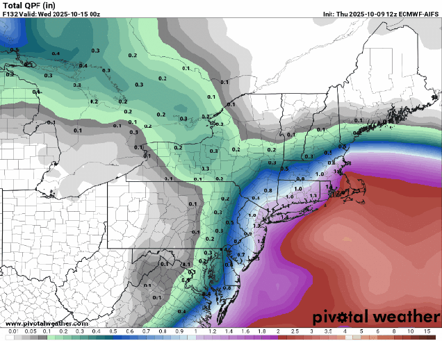
Some slow improvement is expected as the week goes on, but the start of the week will be rather nasty.

Low pressure will remain off the East Coast for much of the week. Loop provided by Tropical Tidbits.

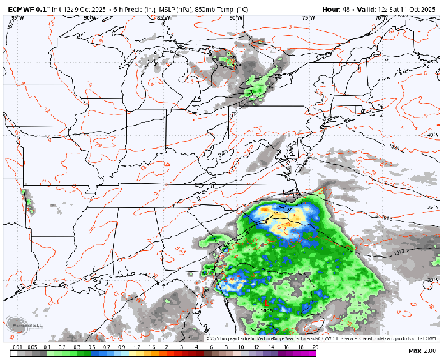
Low pressure continues to meander around off the Mid-Atlantic coast today, with more rain, some of it heavy, strong winds, especially near the coast, and coastal flooding around the time of high tide, especially along east and northeast-facing coastlines. The low will start to drift eastward on Tuesday, with rain tapering off to showers and eventually ending, and winds slowly dying down, but it still won’t be a great day. By Wednesday the system will be south of Nova Scotia, but an upper-level low will move into the Northeast, keeping the clouds and cool temperatures around, with a few showers or some drizzle possible, especially near the coast, as north to northeast winds will remain gusty off the Atlantic. Thursday won’t be that much different than Wednesday as the upper low only slowly moves eastward.

Much of the region will pick up another 1-2″ (or more) of much needed rain before it ends. Images provided by Pivotal Weather.

We finally start to see some improvement by Friday as high pressure continues to build in at the surface, but also aloft. Saturday looks to be the pick of the week with sunshine and milder temperatures with high pressure in control. Sunday will be a warmer day, but we won’t see as much sunshine. Low pressure moving into the Great Lakes will send some clouds into the region. Whether we see any showers before the end of the day is still a question mark, but for now, it looks like most of the day should remain dry.

Temperatures could approach or exceed 70 on Sunday. Image provided by WeatherBell.

Monday: Windy with rain, heavy at times. High 51-58, a little milder across southeastern Massachusetts and Cape Cod.

Monday night: Breezy, rain tapers off to showers. Low 46-53, a little milder across southeastern Massachusetts and Cape Cod.

Tuesday: Cloudy and breezy with more showers, tapering off during the afternoon from west to east. High 55-62.

Tuesday night: Partly to mostly cloudy, showers ending in the evening in eastern areas, winds diminish. Low 45-52.

Wednesday: More clouds than sun, breezy, chance for a few showers or drizzle near the coast. High 58-65.

Wednesday night: Partly cloudy, breezy, a few showers are drizzle along the coast. Low 37-44.

Thursday: Intervals of clouds and sun, breezy, another shower or some drizzle possible near the coast. High 51-58.

Thursday night: Partly cloudy, breezy. Low 36-43.

Friday: Mostly sunny, breezy in the morning. High 55-62.

Saturday: Sunshine and some afternoon clouds. High 58-65.

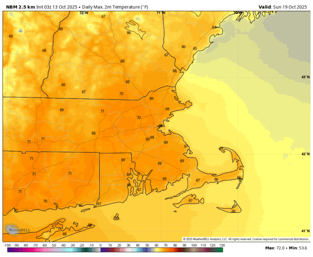
Sunday: Partly sunny, showers possible late in the day. High 64-71.

Weekend Outlook: October 10-13, 2025

We’ve had warm and dry weather for much of the past few months, but that is going to change this weekend.

Freeze Warnings (dark blue) and Frost Advisories (light blue) are in effect for much of the Northeast. Image provided by the National Weather Service.

A large area of high pressure will settle across the region tonight, bringing us clear skies and light winds – the ideal setup for radiational cooling. As a result, we’re looking at the coolest night so far this fall, with widespread frost away from the coast and urban areas, with a freeze expected in the normally colder locations. Friday will feature plenty of sunshine, but we’ll remain on the cool side. As the high starts to slide off to the south and east, winds will shift into the southwest Friday night, so we won’t be as chilly as tonight. Saturday should be a milder day, but we’ll see clouds starting to move in as moisture streams northward from a low pressure area developing off the Carolina coast. That system will drift northward Sunday and Monday, but won’t get this far north, though it will still have a significant impact on the region.

A developing low pressure will impact much of the East Coast this weekend. Loop provided by WeatherBell.

We’ll see rain spreading northward from the system, likely moving in from south to north Sunday afternoon and evening. How far north the rain gets is still a bit of a question mark, but it looks like most of the region should receive some much-needed rainfall. How much rainfall is also a question, but at this point it looks like the heaviest rain will be near the South Coast and also east-facing coastal areas, which some spots could see 1-2 inches of rain, possibly more, before everything starts to wind down on Tuesday.

Some models show the potential for very heavy rainfall with this system. Images provided by Pivotal Weather.

Rain isn’t the only impact from this system though. The pressure gradient between the developing low to the south and high pressure to the north will result in gusty east to northeast winds, especially near the coast, where some gusts in excess of 40 mph are possible, especially later Sunday into Monday. In addition, with tides still near the astronomical high for the month, persistent onshore gusty winds will result in some areas of coastal flooding, especially along east and northeast facing locations. Oh, and the combination of cloudcover, rainfall, and winds, will keep temperatures on the cool side again, especially on Monday.

Wind gusts in excess of 40 mph are possible, especially near the coast, Sunday night and Monday. Image provided by WeatherBell.

Thursday night: Clear and chilly. Low 29-36, milder along the coast and in urban areas.

Friday: Plenty of sunshine. High 56-63.

Friday night: Clear during the evening, some clouds start to filter in from south to north after midnight. Low 38-45, a little milder along the coast and in urban areas.

Saturday: Partly sunny, clouds start to thicken up late in the day. High 60-67.

Saturday night: Mostly cloudy. Low 44-51.

Sunday: Cloudy and becoming windy with rain developing from south to north. High 57-64.

Sunday night: Cloudy and windy with rain likely, possibly heavy at times. Low 48-55.

Monday: Cloudy and windy with more rain, possibly heavy at times. High 54-61, a little milder near the South Coast and Cape Cod.