Weekend Outlook: October 20-23, 2023

For a change, it’s going to rain this weekend. The forecast itself isn’t that simple though, so let us explain.

A cold front in the Midwest and a trough of low pressure off the South Carolina coast will be the main players in our weather for the next few days. Image provided by NOAA.

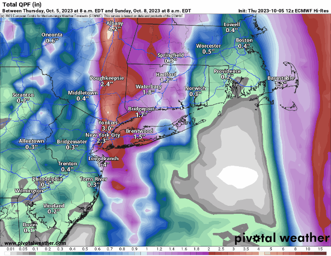
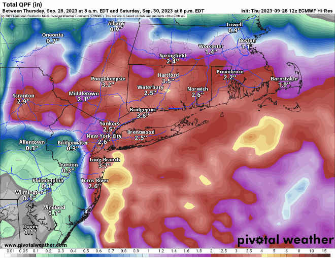
High pressure slides off to the east tonight and clouds start to stream in ahead of a cold front currently crossing the Great Lakes. Meanwhile, a weak area of low pressure will begin to develop off the Carolina coast tonight and head northward. Ahead of both of these, we’ll have a cloudy but mild day on Friday. Some showers are possible during the day, but the bulk of the activity should stay to our west. Showers will become more widespread by evening as the low pressure area to the south draws closer. The combination of the low and the approaching front will produce widespread showers with some bouts of steadier rain through Friday night and Saturday morning, tapering off during the afternoon. While the rain won’t be heavy, some places could see an inch or so by the time it winds down. By Saturday night, the cold front and the low pressure area move offshore, but an upper-level disturbance will move into the Northeast. This will allow the low to slow down or even stall out in the Gulf of Maine while intensifying. This may keep the showers around across parts of Southern Maine and Southern New Hampshire, possibly northern Massachusetts as well, but for most of us, it’ll just be a blustery and cool day with only a few showers around.

Sunday could end up as another damp day according to some of the models. Images provided by Pivotal Weather.

High pressure finally starts to build in for Monday with some clearing, but it will remain breezy and cool. In fact, as winds subside Monday night, and skies become clear, we’ve got a chance for our first widespread frost of the fall. So, if you’ve got some outdoor plants, you may want to prepare to bring them inside.

Monday night will be the coolest night we’ve had around here since the middle of May. Image provided by WeatherBell.

Thursday night: Increasing clouds. Low 46-53.

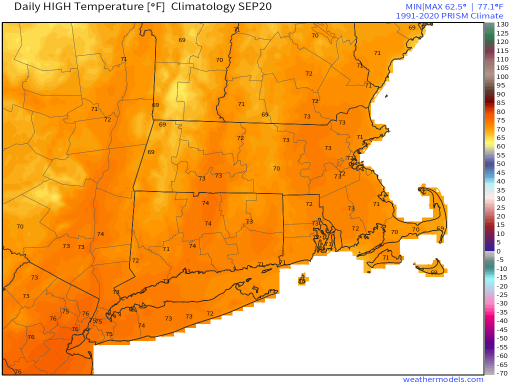
Friday: Mostly cloudy, chance for a few showers. High 60-67.

Friday night: Cloudy with showers likely. Low 52-59.

Saturday: Cloudy with occasional showers and some periods of steadier rain. High 57-64.

Saturday night: Partly to mostly cloudy, showers ending in the evening, becoming breezy. Low 45-52.

Sunday: More clouds than sun, windy, cooler, more showers possible, especially from the Merrimack Valley northward. High 52-59.

Sunday night: Becoming partly cloudy, breezy. Low 38-45.

Monday: A mix of sun and clouds, breezy, especially in the morning. High 53-60.

Weekly Outlook: October 16-22, 2023

There is some more rain in our future, probably on the weekend again, but at least we’re not talking about snow yet.

Another upper-level low will keep us cool and unsettled today. Image provided by Tropical Tidbits.

The week starts off with an upper-level low sitting over New England, keeping us cool and unsettled to start the week. A disturbance rotating around the low may trigger some showers today, but the day won’t be a washout. The upper low starts to lift out on Tuesday, but there will remain enough instability to produce plenty of clouds and possibly a few more showers. High pressure builds in for Wednesday and Thursday with drier and milder weather, but we’ll see more clouds streaming in Thursday night and Friday ahead of another low pressure system. The main storm system will head into the Great Lakes while a secondary low pressure area develops across the Mid-Atlantic states and lifts northward into the region on Saturday, bringing us another round of rain. Right now, the consensus among the models is to develop a rather potent low pressure system and move it up the Hudson Valley during the day Saturday. This would result in a breezy, mild, and showery day, rather than a complete washout. Obviously, there’s plenty of time for things to change, so we’ll be keeping a close eye on it. Another upper-level low moves in for Sunday with more clouds, some showers, and cooler temperatures.

Some mild weather by mid-October standards is expected later this week. Image provided by WeatherBell.

Monday: More clouds than sun, chance for a few popup showers. High 53-60.

Monday night: Partly to mostly cloudy, showers taper off in the evening. Low 42-49.

Tuesday: Partly sunny, chance for another shower or two. High 55-62.

Tuesday night: Partly cloudy. Low 42-49.

Wednesday: A mix of sun and clouds. High 57-64.

Thursday: Partly to mostly sunny, breezy. High 60-67.

Friday: Mostly cloudy, breezy, showers develop at night. High 61-68.

Saturday: Mostly cloudy, breezy, scattered showers likely. High 59-66.

Sunday: Partly sunny, windy, cooler, chance for a few showers. High 54-61.

Weekend Outlook: October 13-16, 2023

A weekend without rain? Those have been rare since June, but for many of us, it will be a reality this weekend.

Average high temperatures for mid-October are in the lower to middle 60s. Images provided by Weathermodels.com

A weak cold front will cross the region this evening with little fanfare. Behind it, northwest winds will usher some cooler air in for Friday, but we’ll also have a decent amount of sunshine, with seasonably cool temperatures. Low pressure will then start to move out of the Great Lakes and head toward the Mid-Atlantic states. That will send some clouds in for Saturday, but the low should be far enough to the south that most of the rain stays offshore as well. A few showers are possible later Saturday into early Sunday near the South Coast, and there could be a little drizzle near eastern coastal locations, but for the most part we’ll stay dry. We may see a bit more sunshine on Sunday, but clouds come back Monday as another system moves off the Mid-Atlantic coastline. This may bring in a few showers on Monday, but it looks like most of the rain from this system likely holds off until Tuesday.

Some models bring the rain to the South Coast Saturday evening, some don’t. Images provided by Pivotal Weather.

Thursday night: A few clouds and possibly a stray shower during the evening, otherwise clear. Low 40-47.

Friday: Mostly sunny, breezy. High 57-64.

Friday night: Clear during the evening, some clouds move in overnight. Low 41-48.

Saturday: Becoming partly to mostly cloudy, a late-day shower possible near the South Coast. High 57-64.

Saturday night: Partly to mostly cloudy, a shower or two possible near the South Coast. Low 41-48.

Sunday: More clouds than sunshine, breezy. High 56-63.

Sunday night: Partly to mostly cloudy. Low 43-50.

Monday: Mostly cloudy, breezy, chance for a shower or two. High 55-62.

Weekly Outlook: October 9-15, 2023

Yup, that same weather pattern is still in place that has been for a while now, and another rainy weekend could be coming.

An upper-level low pressure area will remain in place across southeastern Canada through a good chunk of the week, which means temperatures will be below normal, but it shouldn’t be as wet. Monday should be fairly dry, though northeast winds may result in a few ocean-effect rain showers, mainly across Cape Cod and the Islands. A weak frontal system may bring in a few more showers on Tuesday, then high pressure builds in for Wednesday. Another weather system brings in more clouds on Thursday, and possibly a few showers. High pressure noses back in from the north on Friday with some drier weather once again, which brings us to the weekend.

Temperatures will be below normal for the next few days. Image provided by WeatherBell.

Low pressure will move out of the Great Lakes and towards the region later Friday before a secondary low pressure area develops off the Mid-Atlantic coastline, passing south of the region over the weekend. There is some discrepancy among the models in regards to the timing of the system. Some modes have another rainy Saturday into parts of Sunday, some have the rain hold off until Saturday evening, but possibly continue into Monday. Hopefully, we’ll have a better idea of the timing as we get to our Weekend Outlook on Thursday.

The models don’t agree on the timing or placement of low pressure to our south next weekend. Images provided by Pivotal Weather.

Monday: Intervals of clouds and sun, slight chance for a shower across Cape Cod and the Islands. High 57-64.

Monday night: Partly cloudy. Low 40-47.

Tuesday: A mix of sun and clouds, a shower or two possible. High 59-66.

Tuesday night: Partly to mostly cloudy. Low 41-48.

Wednesday: Partly to mostly sunny. High 61-68.

Thursday: Partly to mostly cloudy, breezy with a chance of showers. High 60-67.

Friday: A mix of sun and clouds. High 58-65

Saturday: Cloudy and breezy with a chance of rain. High 55-62.

Sunday: Rain likely, breezy. High 52-59.

Weekend Outlook: October 6-9, 2023

Another rainy Saturday? Yup, we’ve got another rainy Saturday on the way.

Tropical Storm Philippe may have a role in our weather this weekend. Image provided by the National Hurricane Center.

We start off with another foggy night tonight, with plenty of moisture around and high pressure sliding off to the east. Once the fog burns off Friday morning, we’ll still have plenty of clouds ahead of a cold front slowing moving in from the west. A few showers are possible during the day, but they’ll become more likely at night, and through a good chunk of the day on Saturday. Complicating matters is Tropical Storm Philippe, or what’s left of it. It will be moving northward, passing east of the region, but some of the rain from it could move into eastern Massachusetts. Eventually, it’ll get tugged northwestward by an upper-level low (more on that in a minute), moving into Maine or New Brunswick this weekend, with some heavy rain and gusty winds for parts of northern New England. The cold front moves across the region Saturday evening, bringing an end to the rain, then much cooler air settles in behind it. However, that upper-level low over southeastern Canada will move southeastward, which means that despite high pressure building in at the surface, we’ll still have plenty of clouds around Sunday and Monday, with a few popup showers possible.

The heaviest rain will stay well to our west, but there is the potential for some heavy rain in eastern New England this weekend. Images provided by Pivotal Weather.

Thursday night: Becoming mostly cloudy with areas of fog, some of it dense. Low 54-61.

Friday: Partly to mostly cloudy with a chance for a shower or two. High 67-74.

Friday night: Cloudy with showers developing. Low 57-64.

Saturday: Periods of rain and showers. High 61-68.

Saturday night: Showers end, some clearing possible late at night, becoming breezy. Low 46-53.

Sunday: A mix of sun and clouds, windy, cooler. High 57-64.

Sunday night: Clear to partly cloudy, winds slowly diminish. Low 41-48.

Monday: Partly sunny, breezy. High 54-61.

Weekly Outlook: October 2-8, 2023

The first half of the week will feature some fantastic early fall weather, but the weekend isn’t looking as great.

Temperatures will average 5-10 degrees above normal between now and Friday. Image provided by WeatherBell.

High pressure will dominate the region for the next several days. The result will be sunshine and unseasonably warm temperatures through Wednesday, with clear skies, areas of fog, and mild temperatures at night. Thursday looks warm as well, but we’ll see clouds start to stream in as a cold front begins to approach from the west. Friday will feature a lot of clouds, but it will remain mild. We may see a few showers by late in the day, but most of them should hold off until after dark. Low pressure passes north of the region Friday night and Saturday, dragging the cold front through with some rain likely, but temperatures will turn cooler with the cloudcover and rain. The front moves through late Saturday, bringing an end to the rain, then high pressure builds in for Sunday with much cooler conditions. With an upper-level low also moving in, we’ll still see plenty of clouds, with a few pop-up showers possible.

The potential exists for another rather wet Saturday across the region. Images provided by Pivotal Weather.

Monday: Some clouds and a little fog to start the day, then mostly sunny. High 68-75, coolest near the coast.

Monday night: Clear skies, patchy fog develops. Low 47-54.

Tuesday: Plenty of sunshine. High 77-84.

Tuesday night: Clear skies, more fog developing. Low 55-62.

Wednesday: Sunshine with some afternoon clouds. High 75-82, a little cooler near the coast.

Thursday: A sunny start, clouds start to move in during the afternoon. High 71-78.

Friday: Mostly cloudy, not as warm, a few showers possible in the day, more likely at night. High 67-74.

Saturday: Cloudy and cooler with periods of rain and showers likely, ending overnight. High 64-71.

Sunday: Intervals of clouds and sun, breezy, much cooler, chance for a few showers. High 58-65.

Weekend Outlook: September 29 – October 2, 2023

We’ve got another complicated forecast coming up for the start of the weekend, but the end isn’t complicated at all.

In between the wildfire smoke to the north and east, and all the moisture to the south, we’ve actually got a rather nice day in progress. Loop provided by NOAA.

High pressure will remain in place across southeastern Canada through the weekend. An upper-level low will move from the Great Lakes toward the Northeast, keeping us on the cool side through Saturday. A disturbance rotating around that low will help spawn a low pressure system off the Mid-Atlantic coastline, where there is still plenty of moisture hanging around, some of it being the remains of Ophelia. While the low should stay well to our south, a trough extended from the low towards southern New England will help draw some of that moisture northward, generating plenty of clouds tonight and Friday. The question becomes, how far north does the rain get, and how heavy will it be. There is still a lot of disagreement among the models, but based on the trends in the models and their known biases, we’re thinking that most of the rain will be south of the Mass Pike, with the steadiest and likely heaviest rain mainly south of Route 44. It wouldn’t be a surprise if no rain falls at all from the Merrimack Valley into southern New Hampshire. The rain winds down Saturday morning, and we may see some clearing by late in the day. After that, high pressure builds back in for Sunday and Monday with sunshine and warmer temperatures.

The models still don’t agree on how much rain much of our area will see tomorrow and Saturday. Images provided by Pivotal Weather.

Thursday night: Becoming mostly cloudy, patchy fog may develop once again. Low 46-53.

Friday: Mostly cloudy with showers developing, mainly south of the Mass Pike. High 60-67.

Friday night: Cloudy with periods of rain and showers, mainly south of the Mass Pike. Some of the rain could be heavy near the South Coast. Low 50-57.

Saturday: Showers ending around midday, some breaks of sun possible by late afternoon, especially from the Merrimack Valley northward. High 62-69.

Saturday night: Clearing. Low 49-56.

Sunday: Plenty of sunshine. High 68-75.

Sunday night: Clear to partly cloudy. Low 52-59.

Monday: Sunshine and a few clouds. High 67-74.

Weekly Outlook: September 25-October 1, 2023

Drier weather is on the way, but the week will start off cool and wet.

Normal high temperatures for the end of September are in the upper 60s. Image provided by Weathermodels.com

The remains of Tropical Storm Ophelia will pass south of the region today, with more clouds, some rain showers, especially south of the Mass Pike, and mainly through early afternoon, and breezy conditions, due to the gradient between what’s left of Ophelia and the large high pressure area well to the north. An upper-level low swings through on Tuesday with more clouds, and possibly a few showers,, but most of us will remain dry. High pressure then builds in for the rest of the week and the weekend with dry and seasonably cool conditions. There will be some disturbed weather hanging around to the south during the end of the week and the weekend, but for now at least, it looks like the high pressure area should keep us dry.

We need to keep an eye on some moisture associated with a disturbance that should remain south of the region at the end of the week. Images provided by Pivotal Weather.

Monday: Cloudy breezy, and cool with more showers, mainly south of the Mass Pike, tapering off in the afternoon. Some sunny breaks may develop by late afternoon in southern New Hampshire. High 58-65.

Monday night: Partly to mostly cloudy, a few lingering showers near the South Coast. Low 48-55.

Tuesday: Intervals of clouds and sun, slight chance for a shower. High 58-65.

Tuesday night: Becoming clear to partly cloudy. Low 42-49, a little milder near the coast from Boston southward.

Wednesday: A mix of sun and clouds. High 61-68.

Thursday: Partly sunny. High 63-70.

Friday: Intervals of sun and clouds. High 63-70.

Saturday: Partly to mostly sunny. High 65-72.

Sunday: A mix of sun and clouds. High 67-74.

Weekend Outlook: September 22-25, 2023

We’ve got a rather complicated forecast coming up as we officially end astronomical summer and begin fall with the autumnal equinox at 2:50am Saturday.

Fall officially begins early Saturday morning. Image provided by CBS News.

High pressure to our north will keep us dry and seasonably cool into Friday. However, high clouds will begin to stream northward from what is currently being called “Potential Tropical Cyclone 16”, but will likely be named Ophelia soon. Whether it is tropical or subtropical doesn’t have much impact on the forecast. Future Ophelia will likely strengthen a bit before moving into eastern North Carolina early Saturday.

Forecast track for Potential Tropical Cyclone 16. Image provided by the National Hurricane Center.

As our high pressure system moves off to the east, southerly flow will send the rain up the East Coast. This is where things get tricky, because another high pressure area will also be trying to build in from the northwest. We’ve seen this setup many times before, and what usually happens is that the high wins out and keeps most of the rain (or snow in the winter) off to our south. However, anytime there’s been a chance for rain this summer, we’ve ended up with a lot of rain. So, taking both of those ideas into account, here’s what we think will happen:

The rain will move up the coast on Friday and Friday night, but will have a tough time moving in early Saturday with plenty of dry air in place. Eventually, the rain will win out, overspreading the region during the afternoon. How far north it gets is still a big question, and it wouldn’t be a surprise to us if the rain never made it across the MA/NH border. Some of the rain may be heavy during the late afternoon and evening, especially south of the Mass Pike. The rain may taper off for a while Saturday night and early Sunday as the second high tries to build in, and the low to the south moves up into the Mid-Atlantic states. A second batch of showers is possible later Sunday and Sunday night as the low starts to turn more toward the northeast, eventually passing out to sea south of New England on Monday, with some additional showers possible.

Heavy rain is likely across parts of the region this weekend, but how far north is still in doubt. Images provided by Pivotal Weather.

Thursday night: Clear skies, though some high clouds will start to move in. Low 47-54.

Friday: Sunshine filtered through high clouds in the morning, clouds thicken up in the afternoon. High 65-72.

Friday night: Mostly cloudy. Low 49-56.

Saturday: Showers developing from south to north during the late morning and early afternoon, becoming a steady and potentially heavy rain by late afternoon. High 58-65 during the morning, temperatures drop into the 50s during the afternoon.

Saturday night: Rain tapers off to showers during the evening, mostly cloudy overnight. Low 49-56.

Sunday: Plenty of clouds, some showers may redevelop during the afternoon. High 60-67.

Sunday night: Cloudy with showers likely. Low 50-57.

Monday: Mostly cloudy, more showers around, especially during the morning. High 61-68.

Weekly Outlook: September 18-24, 2023

Another rainy Monday is on the way, but much of the upcoming week will feature dry weather.

A frontal system will move into the region today while an area of low pressure develops off the Mid-Atlantic coastline. The low will ride up the front, passing close to or across southeastern New England later today. The result will be periods of rain and showers through the day today, some of which could be heavy at times. Some localized flooding is possible in spots, but we should have any flooding to the magnitude we saw last Monday. Everything winds down tonight as the system pulls away, then high pressure builds in with dry and seasonably mild conditions for Tuesday through Friday and probably Saturday as well.

The models are all forecasting heavy rain across the region today. Images provided by Pivotal Weather.

Late Saturday and Sunday is when things get complicated again. Low pressure will begin to develop off the Southeast coast later this week. As our high pressure system moves off to the east, moisture from the low to the south will start to head northward, and may result in some wet weather around here for Saturday night and Sunday. The forecast models don’t all have the same timing and evolution of this system, so we’ll likely be refining this part of the forecast when we get to our Weekend Outlook on Thursday.

Normal high temperatures for late-September are in the lower 70s.

Monday: Periods of rain and showers, some of the rain may be heavy at times. High 64-71.

Monday night: Showers ending, then areas of fog develop. Low 54-61.

Tuesday: Becoming mostly sunny and breezy. High 68-75.

Tuesday night: Clear skies. Low 50-57.

Wednesday: Plenty of sunshine. High 69-76.

Thursday: Sunshine and a few clouds. High 68-75.

Friday: A mix of sun and clouds. High 68-75.

Saturday: Intervals of clouds and sun, rain possible at night. High 65-72.

Sunday: Mostly cloudy with a chance of showers. High 65-72.