This week will be the coolest week we’ve had around here in the past six months.
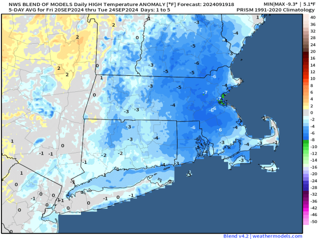
Temperatures will be below normal for much of the upcoming week. Image provided by Weathermodels.com
We’re starting the week off on a damp note with a low pressure system crossing the region, generating a few more showers, mainly during the morning hours today. We’ll start to clear out behind a cold front this afternoon, with gusty northwest winds developing. We may turn mild this afternoon, with parts of the region topping 60, especially south of Boston, but much cooler air will settle in behind the front tonight. High pressure builds in with dry and cool conditions for Tuesday into Thursday, but with an upper-level low moving across the Northeast, it will remain breezy, with a few clouds around at times. In addition, the onshore flow around the high pressure area may bring a few clouds and even a shower or two into coastal areas. To our north, this upper-level low will generate some snow showers across parts of Northern New England, especially in the mountains, but that’s not a concern around here. As the high slides off to the east, temperatures should start to moderate at the end of the week. Another frontal system may move in for the end of the weekend, but for now, it doesn’t look like it will have much moisture to work with.
It’s getting toward that time of year. Some snow is likely in the mountains this week. Image provided by WeatherBell.
Monday: Cloudy and becoming breezy with showers ending by early afternoon, skies start to clear out late in the day. High 52-59 north of the Mass Pike, 60-67 south of the Pike.
Monday night: Clear to partly cloudy. Low 34-41.
Tuesday: Sunshine with some afternoon clouds, breezy, and cooler, slight chance for an afternoon shower near the coast. High 49-56.
Tuesday night: Clear to partly cloudy. Low 34-41.
Wednesday: A mix of sun and clouds, slight chance for a shower along the coast. High 48-55.
Thursday: Partly to mostly sunny, another shower possible near the coastline. High 52-59.
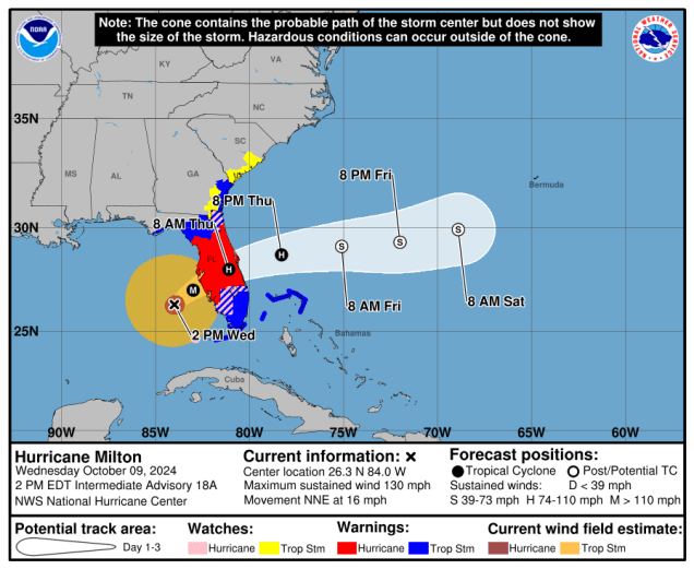
Hurricane Milton remains a Category 4 storm as it begins to close in on the Florida Gulf Coast.
Hurricane Milton is heading toward western Florida. Loop provided by Tropical Tidbits.
After peaking as a Category 5 hurricane twice over the past few days, Hurricane Milton is starting to weaken, and will continue to do so right up until landfall along the Florida Gulf Coast tonight. As of 3pm EDT Milton still had maximum sustained winds near 130 mph, and was centered about 110 miles west of Ft. Myers, Florida, moving toward the northeast at 16 mph. A variety of watches and warnings are in effect for most of Florida as well as parts of the Bahamas and Southeast coastline.
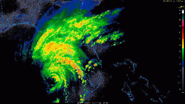
Milton’s eye shows up on the radar from Tampa. Loop provided by the College of DuPage.
At this point, the forecast for Milton is fairly straightforward. Upper-level conditions are becoming increasingly hostile, so Milton should continue to weaken, but will likely still be a Category 3 or Category 2 hurricane at landfall around or just after midnight tonight. It should turn a bit more toward the east-northeast this evening, with landfall likely south of Tampa Bay, probably somewhere in the vicinity of Sarasota. Once inland, it will move east-northeastward across Florida while continuing to weaken, likely emerging in the Atlantic Thursday morning as a Category 1 hurricane. It should then continue out into the open Atlantic. This track should keep the strongest winds south of Interstate 4, sparing the Tampa/Orlando/Daytona Beach areas from the worst of the conditions.
Milton should cross central Florida tonight then move into the Atlantic. Image provided by the National Hurricane Center.
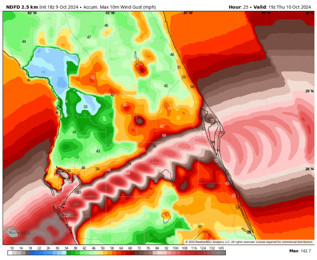
Milton has already begun to transition into an extratropical system, and by the time it moves into the Atlantic Thursday morning, that transition should be nearly complete. Unfortunately, this will result in Milton becoming and even larger storm, and the strong winds, albeit weaker than they are now, spread out over a much larger area. While the winds will result in widespread damage, especially near landfall, the strongest winds should stay south of Tampa, Orlando, and Daytona Beach. These areas may see gusts to hurricane strength, especially in Tampa, but wind will not be the biggest concern here.
The strongest winds are expected to stay just south of the Interstate-4 corridor. Image provided by WeatherBell.
Heavy rain has been falling across parts of Florida, especially central Florida for a few days now, and Milton will only worsen that. Much of the region has received 1-4 inches of rain already this week, and along and north of the track, additional rainfall totals of 10-15 inches or more are likely by Thursday morning, resulting in widespread significant flooding. This does include the metro areas of Tampa, Orlando, and Daytona.
Torrential rainfall is expected along and north of Milton’s track. Image provided by Weathermodels.com
The biggest concern is along the Florida Gulf Coast, where a large storm surge is expected near and south of where the center makes landfall. Milton has been piling up the water in the Gulf for a couple of days now, and even though it has begun weakening, the seas will not subside much, if at all, before landfall. A storm surge if 10-14 feet is expected from the mouth of Tampa Bay southward to the Charlotte Harbor area. With landfall expected near or just before high tide, it will exacerbate the storm surge a bit more. Much of the remainder of the Florida Gulf Coast can still expect a significant storm surge, especially southward, including the Naples and Fort Myers areas, but with the storm passing south of Tampa Bay, we were spared the worst-case scenario of a storm passing just to the north, sending a 15-foot storm surge right up the Bay and into downtown Tampa. Storm surge will also be a concern, but to a lesser degree along the Atlantic coast, mainly across central and northeastern Florida from Melbourne to Jacksonville, where a 3-5 foot storm surge is still expected.
Storm Surge is the biggest concern along the Florida Gulf Coast. Image provided by the National Hurricane Center.
If that wasn’t enough, Milton will also produce numerous tornadoes across parts of central and southern Florida today and tonight. There have already been more than half a dozen reports of tornadoes across parts of the area, and a Tornado Watch remains in effect through this evening for much of central and southern Florida. It will almost certainly be extended through the night.
Tornadoes are likely across central and southern Florida ahead of Milton. Image provided by the Storm Prediction Center.
Hurricane Milton peaked as a Category 5 storm on Monday with a central pressure of 897mb. The lower the pressure the stronger the storm. This made it the 5th strongest storm on record in the Atlantic Basin, and one of just 7 storms to have a central pressure of 900mb or lower. The last storm to do so was Hurricane Wilma in October of 2005. Wilma’s pressure bottomed out at 882mb, which is the lowest sea-level pressure recorded in the Atlantic, and second lowest in the western hemisphere (Hurricane Patricia in the Eastern Pacific had a pressure of 872mb in 2015).
Storm
Pressure
Year
Wilma
882mb
2005
Gilbert
888mb
1988
Labor Day
892mb
1935
Rita
895mb
2005
Milton
897mb
2024
Strongest hurricanes in the Atlantic Basin by pressure.
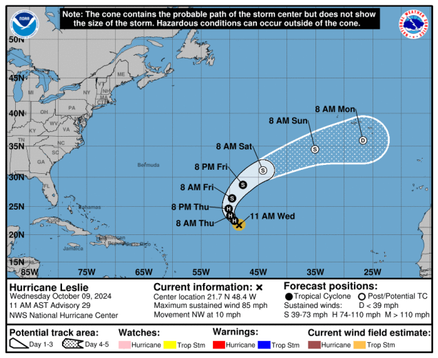
Milton isn’t the only active storm right now. We also have Hurricane Leslie, centered about 985 miles east-northeast of the Northern Leeward Islands, moving toward the northwest at 10 mph. Leslie weakened to a tropical storm on Tuesday, but has regained hurricane strength, with maximum sustained winds near 85 mph. Leslie may strengthen a little more tonight and Wednesday before a weakening trend commences. Leslie should turn more toward the north and northeast, remaining over open water while steadily weakening over the next few days, before becoming extratropical this weekend.
Forecast track for Hurricane Leslie. Image provided by the National Hurricane Center.
We’re also keeping an eye on an area of low pressure a few hundred miles west-southwest of Bermuda. It’s not tropical in origin, but it does have a small window over the next day or so where it could acquire some tropical characteristics, before upper-level conditions become unfavorable once again. Hurricane Season doesn’t officially end until November 30, so chances are, there will be more storms forming over the coming weeks.
A good portion of the upcoming week will feature cool and dry weather. Meanwhile, all eyes are turning to Hurricane Milton in the Gulf of Mexico.
Temperatures will be below normal for the next several days across the region. Image provided by Weathermodels.com.
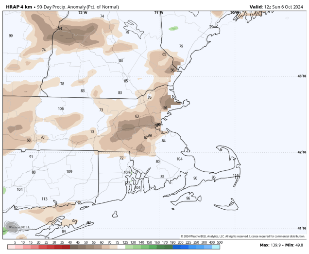
A cold front will cross the region today with some showers likely. While we need the rain, as we’re starting to slip into a drought, this will not be nearly enough rain to alleviate it. The front moves offshore late today, then we’ll clear out and turn cooler for Tuesday. With clear skies and light winds Tuesday night, some patchy frost is possible in the normally colder locations, especially well north and west of Boston. Another front moves through on Wednesday with little fanfare, but it will bring even cooler weather in for Thursday, when many locations likely won’t reach 60 for a high temperature. High pressure then slides offshore, allowing temperatures to moderate a little on Friday, and even more on Saturday, when many places may top 70 again. Another system may bring in some cooler and unsettled conditions for late Sunday and Columbus Day.
Rainfall has been well below normal for a few months now, and we’re not going to get much help this week. Image provided by WeatherBell.
Meanwhile, the tropics remain active with three hurricanes, but one of them is a significant threat to land. As of 5am, Hurricane Milton was centered about 750 miles west-southwest of Tampa, Florida, moving toward the east-southeast at 5 mph. Maximum sustained winds were near 100 mph. Hurricane Warnings are in effect for parts of the Yucatan Peninsula, and Hurricane Watches are in effect for much of western Florida. Milton is expected to continue to strengthen for the next day or so, likely reaching Category 4 intensity as it turns more toward the northeast. However, by later Tuesday, upper-level conditions will become more hostile, and Milton should start to weaken, and in fact, could weaken rather quickly. However, it will still likely make landfall along the Florida Gulf Coast late Wednesday or early Thursday, but exactly where landfall will happen is still a question mark, and a fairly significant one. The strongest winds and highest storm surge will be to the right of the center. Some models bring the storm in near or north of Tampa, others to the south. A track south of Tampa means offshore winds for Tampa Bay, and not only would the storm surge be a lot less, it could actually send much of the water out of the Bay. However, a track just to the north of Tampa sends all the surge into the Bay, which would be very bad for the Tampa area. No matter where it makes landfall, it will bring additional heavy rain to much of Florida, with strong winds well inland. Once it makes landfall, it should continue to steadily weaken, and become extratropical as it moves off the east coast of Florida and into the Atlantic.
Hurricane Milton continues to strengthen in the Gulf of Mexico. Loop provided by NOAA.
Well out in the Atlantic, we have Hurricanes Kirk and Leslie. As of 5am, Kirk still had maximum sustained winds near 75 mph, and was centered about 765 miles west-northwest of the Azores, moving toward the northeast at 30 mph. Kirk is expected to become extratropical later today as it heads eastward, and will bring strong winds and heavy rain to parts of northwestern Europe later this week. Meanwhile, Hurricane Leslie is centered about 1065 miles west of the Cabo Verde Islands, heading northwestward at 13 mph. Maximum sustained winds were near 90 mph. Leslie is expected to continue northwestward over open water this week while slowly weakening.
The tropics remain active today. Image provided by the Canadian Hurricane Centre.
Monday: Cloudy with showers likely, ending late in the day. High 60-67.
Monday night: Clearing. Low 43-50.
Tuesday: Sunshine and a few clouds. High 59-66.
Tuesday night: Clear to partly cloudy. Low 38-45.
Wednesday: Sunshine and some afternoon clouds. High 58-65.
Thursday: Mostly sunny, breezy, and cool. High 54-61.
Friday: Lots of sunshine. High 58-65.
Saturday: Partly to mostly sunny, breezy, and milder. High 66-73.
Sunday: A mix of sun and clouds, showers possible at night. High 61-68.
Columbus Day: Partly to mostly cloudy and breezy with a chance for showers. High 53-60.
Changes are on the way as we head through the weekend. Meanwhile, the tropics remain active.
Drought conditions are beginning to develop across our area. Image provided by the National Drought Mitigation Center.
High pressure remains in control into Friday with dry and mild conditions. A cold front will start to move our way on Friday, with clouds streaming in ahead of it in the afternoon. The front will produce a few showers late Friday night and early Saturday, then skies clear out in the afternoon behind the front. We’ll remain fairly mild behind the front on Saturday, but as high pressure slowly moves in, we’ll turn a little cooler on Sunday despite more sunshine. Clouds start to filter in later Sunday ahead of a stronger cold front. That front will bring in some rain late Sunday night and Monday, but its bigger impact will be even cooler weather moving in behind it for the middle part of next week.
Cooler than normal temperatures are expected across the region next week. Image provided by Weathermodels.com.
The Atlantic remains active with two named storms, though neither is expected to impact land over the next week or so. Hurricane Kirk is now a Category 3 hurricane with maximum sustained winds near 125 mph. It is centered about 1130 miles east of the Northern Leeward Islands, moving toward the northwest at 10 mph. Kirk may strengthen a bit more, likely reaching Category 4 strength, but it will turn more toward the north and then northeast, crossing the open waters of the North Atlantic. It should start to weaken over the weekend, and become extratropical early next week. It could impact parts of western Europe with strong winds and heavy rain toward the middle to latter part of next week. We also have Tropical Storm Leslie, which has maximum sustained winds near 45 mph. Leslie is centered about 540 miles southwest of the Cabo Verde Islands, moving toward the west at 5 mph. Forecasts call for Leslie to steadily strengthen, likely becoming a hurricane in the next day or two. Leslie could become a rather potent storm by early next week, but it should be turning more toward the northwest, and will likely not impact any land areas.
Both Kirk and Leslie should remain over open water for the next several days. Image provided by the Canadian Hurricane Centre.
Thursday night: Partly cloudy, areas of patchy fog may develop. Low 47-54.
Friday: Some morning sun, then clouds increase and thicken up in the afternoon. High 67-74.
Friday night: Mostly cloudy with some showers developing, mostly after midnight. Low 52-59.
Saturday: Showers end in the morning, skies clear out in the afternoon. High 67-74.
Saturday night: Clear skies, cooler. Low 44-51.
Sunday: Lots of sunshine, clouds start to move in by late in the day. High 62-69.
We’re flipping the calendar to October, but it will remain fairly mild around here this week and pretty active in the tropics.
Friday looks like the pick of the week with temperatures well into the 70s for much of the region. Image provided by WeatherBell.
The week starts off with high pressure in control, keeping us dry and seasonably cool, but sunshine will be limited. The combination of east to northeast winds off the Atlantic and high clouds streaming in from what’s left of Helene will result in gray skies for the most part, with a little fog developing each morning as well. A cold front moves in on Wednesday, but it will only be accompanied by a few showers, so much of the region may remain dry once again, but temperatures should turn milder with southwest winds ahead of the front. High pressure builds in behind the front with clearing and mild temperatures for Thursday and Friday. Another cold front will move early in the weekend with some more showers, then high pressure returns for the end of the weekend.
The tropics remain active to start the week. Images provided by the National Hurricane Center.
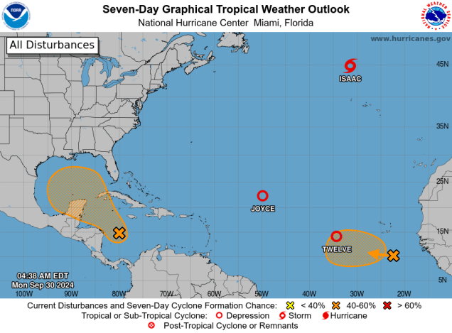
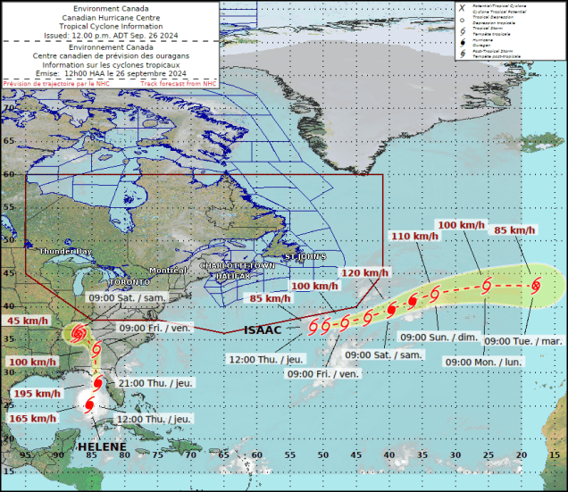
As for the tropics, we have three active systems right now, and another could be on the way. Tropical Storm Isaac was centered about 515 miles north-northwest of the Azores as of 5am Monday, moving toward the east-northeast at 15 mph. Maximum sustained winds were down to 65mph. Isaac should become extratropical later today while heading northeastward over the open waters of the North Atlantic. Tropical Depression Joyce is centered about 910 miles east-northeast of the Northern Leeward Islands, moving toward the west at 2mph. Maximum sustained winds were down to 35 mph, and the storm is expected to turn northward and dissipate over open water in the next day or two. Tropical Depression 12 is centered about 690 miles west of the Cabo Verde Islands, moving toward the west at 8 mph. Maximum sustained winds are near 35 mph. The system should quickly strengthen, becoming a tropical storm later today, and a hurricane in the next couple of days. It could become a rather potent storm later this week, but it should turn more toward the northwest, not impacting any land areas at all.
Tropical Depression 12 is getting better organized this morning. Loop provided by NOAA.
There are two other areas we’re keeping an eye on this week. The first is the western Caribbean, where there is a mass of disorganized showers and thunderstorms this morning, but forecast models show the potential for them to organize into a system over the next few days. Assuming it develops, it could move into the Gulf of Mexico later this week, but it’s far too early to speculate on where it may go beyond that, or how strong it might be, as there isn’t a system yet to track. The other area is a tropical wave that just moved off the west coast of Africa. There’s not much too it right now, but forecast models show the potential for it to develop as it moves westward across the Atlantic later this week.
The various members of the ECMWF Ensemble show the Atlantic remaining active over the next two weeks. Loop provided by Weathermodels.com.
Monday: Areas of morning fog, then intervals of clouds and sunshine. High 67-74.
Monday night: Mostly cloudy with some patchy fog. Low 51-58.
Tuesday: Partly to mostly cloudy. High 62-69.
Tuesday night: Mostly cloudy. Low 49-56.
Wednesday: Partly sunny, slight chance for a shower. High 62-69.
Thursday: A mix of sun and clouds. High 68-75.
Friday: Partly sunny, showers possible at night. High 71-78.
Saturday: Chance for morning showers, then becoming partly to mostly sunny. High 66-73.
Once the rain ends, we’ve got some rather nice weather coming up for the weekend. Meanwhile, the tropics are getting active again with Major Hurricane Helene heading for the Florida Panhandle, Tropical Storm Isaac in the North Atlantic, and potentially another system this weekend.
Some much-needed rainfall is expected across the region tonight. Image provided by WeatherBell.
A cold front will cross the region tonight, taking the rain with it by morning as it moves offshore. High pressure will then build in, and remain in control through Monday, keeping us dry and mild, but don’t expect bright sunshine the entire time. We’ll have some slow clearing behind the front on Friday, especially near the South Coast and the Cape. After that, some high-level moisture from Hurricane Helene and its remnants (more on that in a minute) will stream up here. This will result in filtered sunshine for Saturday and likely part of Sunday too. We’ll also have northeast winds around the high pressure area to our north bringing in some clouds at times from the Atlantic. Monday will probably feature the most sunshine, but there will still be some clouds around.
The tropics are getting active again with both Hurricane Helene and Tropical Storm Isaac. Image provided by the Canadian Hurricane Centre.
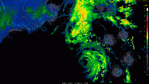
Hurricane Helene continues to strength as it moves across the eastern Gulf of Mexico. As of 4pm EDT, Helene was centered about 145 miles west-southwest of Tampa, Florida, moving toward the north-northeast at 21 mph. Maximum sustained winds were near 120 mph, making Helene at Category 3 Hurricane. Helene’s future is fairly simple at this point. It will continue north-northeastward, with a little more strengthening likely, then it will make landfall in the Florida Big Bend area tonight. This is a sparsely populated region of Florida, which is the only “good” news we have with this storm. A storm surge of 15-20 feet is likely near and to the right of where the center makes landfall. Helene is a very large storm, with tropical storm force winds up to 350 miles from the center of the storm. With this in mind, strong winds are likely well inland after landfall, likely into southern or central Georgia, with widespread wind damage expected.
Hurricane Helene is marching toward the Florida Big Bend. Loop provided by the College of DuPage.
The biggest threat will be heavy rain well inland. Much of the Southeast has already received 3-6 inches of rain in the past day or two from a frontal system, and Helene will add another 5-10 inches or more to that. While this region has been in a drought and needs rainfall, too much rainfall doesn’t help as much and creates widespread flooding. An upper-level low pressure system over the Mississippi Valley will capture the remains of Helene this weekend, slowing it down across the Tennessee Valley before it finally dissipates, bringing even more rain to this region as well.
Helene will produce heavy rain over a very large area over the next few days. Image provided by the National Hurricane Center.
Helene isn’t the only show in town though. We also have Tropical Storm Isaac, centered about 820 miles east-northeast of Bermuda as of 11am EDT, moving toward the east at 12 mph. Maximum sustained winds are near 50 mph. Isaac is expected to steadily strengthen, and could become a hurricane this weekend. It should continue eastward or east-northeastward over the open waters of the North Atlantic, becoming extratropical early next week, at which point it could be heading towards Europe.
Tropical Storm Isaac is gradually organizing in the North Atlantic. Loop provided by NOAA.
But wait, there’s more! Another area of low pressure in the central Atlantic, several hundred miles west of the Cabo Verde Islands continues to get better organized this afternoon, and conditions are favorable for it to become a tropical depression later today or Friday. The system could become a tropical storm over the weekend, but should eventually turn more toward the north and head out into the open Atlantic without impacting any land areas for the next week or so.
The next system should head out to sea without impacting land. Loop provided by Tomer Burg.
Thursday night: Cloudy with rain gradually ending, some clearing late at night, mainly from the Merrimack Valley northward, some patchy fog may also develop. Low 54-61.
Friday: A few lingering showers early across Cape Cod and the South Coast, otherwise, skies become mostly sunny in the morning, then high clouds stream back in during the afternoon. High 69-76.
Friday night: Partly to mostly cloudy. Low 51-58.
Saturday: Sunshine filtered through high clouds. High 66-73.
Saturday night: Partly to mostly cloudy. Low 50-57.
Sunday was the first day of fall, and we’ll have some fall weather for most of the upcoming week.
Temperatures will be a little cooler than normal over the next several days. Image provided by Weathermodels.com
The low pressure system that brought all the rain and cool weather to the region over the weekend has drifted off to the south, and high pressure has built in from the north, which will bring us some drier weather for the next few days. However, the flow in between the two systems will result in northeast winds, keeping us cool, while also keeping some clouds around. By Wednesday, we’ll see a frontal system start to approach from the west, bringing more clouds in. It looks like most of the rain should hold off until night time, so Wednesday should be another dry day. That system will be a slow mover though, so another wet day is likely on Thursday. High pressure builds in for Friday and the weekend with drier air, but it’s not as simple as that may sound.
The models are in good agreement that we should get some beneficial rainfall Wednesday night and Thursday. Image provided by Pivotal Weather.
A tropical system is likely to develop in the Gulf of Mexico over the next day or two, and forecast models show it becoming a formidable system before landfall somewhere between New Orleans and Tampa later this week. Once inland, it will rapidly weaken, but the moisture from it will stream northward. Some models have the high pressure area block that moisture from getting up here, while other models have it get close, possibly to the South Coast, before the high blocks any farther progress northward. So, for now, our forecast is for dry weather next weekend, but that could change by the time we get to our Weekend Outlook on Thursday.
Most of the Ensemble members are in good agreement on a track toward the Florida Panhandle later this week with a developing tropical system. Loop provided by Tomer Burg.
Monday: More clouds than sunshine, breezy near the coast. High 60-67.
Monday night: Partly to mostly cloudy. Low 48-55.
Tuesday: Intervals of clouds and sun, breezy near the coast. High 61-68.
Tuesday night: Mostly cloudy. Low 50-57.
Wednesday: Plenty of clouds, slight chance for a shower during the day, more likely at night. High 62-69.
Thursday: Cloudy with showers likely, ending late in the day. High 64-71.
Astronomical summer ends this weekend and so does our extended stretch of dry and warm weather.
Much cooler weather is expected for the weekend. Image provided by Weathermodels.com
In the big picture, the forecast for the next few days is fairly simple, but the details aren’t so simple. An area of low pressure will meander around south of New England for the next few days while high pressure remains in place to the north. In between the two, we’ll have increasing northeasterly winds, bringing cooler air into the region. The big question is in regards to the shield of rain around the low pressure system, and how far inland it penetrates. The computer models all have varying ideas on this, so they don’t provide a lot of help in this case, so we’re relying on past experience and gut feeling for the most part. The best chance for rain will obviously be closer to the system itself, which means Cape Cod, the Islands, and likely the South Coast and parts of southeastern Massachusetts. Farther north and west, chances decrease fairly rapidly, as dry air from the high pressure system will keep most of the moisture from reaching the ground. In fact, there’s a pretty good chance that it remains dry, especially once you get north and west of Interstate 495, and possibly Interstate 95. For the areas where we do expect rain, it will rain off and on at times from now into part of Saturday. None of the days will be a washout, and there will be extended periods of dry weather, especially as you head farther inland, but there will be some episodes of steadier and potentially heavier rain, especially on Cape Cod.
The models don’t agree on how far inland the rain will penetrate. Images provided by Pivotal Weather.
The system should start to pull away later Saturday, with gradual clearing on Sunday, which is the first day of Autumn. The Autumnal Equinox occurs at 8:43am Sunday, officially ending summer. While we should see some sunshine developing, temperatures will stay on the cool side, thanks to the northeast wind, with most of the region not getting out of the 60s. High pressure builds back in for Monday, with more dry and cool conditions.
Astronomical Fall begins with the Autumnal Equinox at 8:43am Sunday. Image provided by EarthSky.org
Thursday night: Mostly cloudy with showers likely, favoring areas south of Boston, breezy. Low 57-64.
Friday: Cloudy and breezy with occasional showers and some periods of steadier rain, especially south of Boston. High 63-70.
Friday night: Plenty of clouds with more showers, again, favoring areas south of Boston, still breezy. Low 54-61.
Saturday: Mostly cloudy, a few more showers around, mostly in the morning, and again, mostly south of Boston, breezy near the coast. High 61-68.
Saturday night: Partly to mostly cloudy. Low 50-57, a little milder across Cape Cod.
Sunday: Skies gradually become partly to mostly sunny, with the most sunshine north and west of Boston, breezy again. High 61-68.
Sunday night: Clear to partly cloudy. Low 46-53, a little milder across Cape Cod.
A couple more dry and warm days are coming up, but changes are coming later this week.
Much cooler weather is expected to move in by next weekend. Image provided by Weathermodels.com
High pressure remains in control to start the week with more sunshine and warm temperatures, though a seabreeze will keep coastal areas a little cooler. We’ll also see some high clouds start to filter the sunshine today as they stream northward from a low pressure system near the Carolinas. Clouds will continue to increase and thicken on Tuesday as that system pushes farther inland across the Carolinas, but we’ll remain dry and warm. On Wednesday, the high moves out, but it should keep enough dry air in place to prevent the rain from moving in as the low pressure system continues moving into the Mid-Atlantic states. That low will start to head eastward, spreading some rain in for Wednesday night and Thursday, but how far north the rain gets is still a big question mark. There’s a decent chance that areas north of the Mass Pike could remain dry the entire time, while there is the potential for some heavy rain as you get close to the South Coast. Exactly where this battlezone sets up will be the key to the forecast, as we’ll go from dry to very wet in just a short distance. How quickly the low pulls away is also a question mark, with the potential for rain to linger into early Friday near the South Coast. High pressure should build back in for the weekend with dry and much cooler conditions, but we could have another low pressure area lurking to the south, so we’ll need to keep an eye on that as well.
We’ll go from little to no rain to a lot over a short distance later this week. Exactly where remains to be seen. Images provided by Pivotal Weather.
Monday: Sunshine starts to get dimmed by some afternoon high clouds. High 77-84, cooler near the South Coast and Cape Cod.
Monday night: Partly cloudy. Low 50-57.
Tuesday: Increasing and thickening clouds. High 79-86, cooler near the South Coast and Cape Cod.
Tuesday night: Partly to mostly cloudy. Low 54-61.
Wednesday: More clouds than sun, showers possible at night, mainly near the South Coast. High 74-81.
Thursday: Mostly cloudy, showers likely, mainly south of the Mass Pike. High 70-77.
Friday: Partly to mostly cloudy, chance for more showers, mainly during the morning near the South Coast, breezy, cooler. High 66-73.
If you’re on vacation, you’ve got a nearly perfect weekend coming up.
Temperatures will remain above normal into early next week. Image provided by Weathermodels.com
For the most part, we’ve got dry weather through the early to middle of next week thanks to high pressure, but it’s a little more complicated than that. We’ll see a little fog developing tonight, but once it burns off, we’ll enjoy a warm day. A weak boundary dropping southward could trigger a stray shower or thunderstorm, favoring areas from northeastern Massachusetts into southern New Hampshire, but we’re not expecting any widespread showers. Fog may redevelop Friday night, then high pressure builds back in for the weekend with slightly cooler conditions as winds shift into the north. By Monday, the high will move offshore, winds will become southwesterly once again, and we’ll start to warm back up.
It’s been quite dry around here for a while now. That won’t change anytime soon. Image provided by the Northeast Regional Climate Center.
Thursday night: Partly cloudy, areas of fog develop. Low 53-60.
Friday: Mostly sunny, slight chance for a late-day shower or thunderstorm, mainly from northeastern Massachusetts into southern New Hampshire. High 79-86, little cooler near the South Coast and Cape Cod.
Friday night: Clear to partly cloudy, patchy fog may redevelop. Low 55-62.
Saturday: Sunshine and a few clouds. High 76-83, coolest along the coast.
Saturday night: Clear to partly cloudy, a little patchy fog possible again. Low 54-61.
Sunday: Plenty of sunshine. High 74-81, coolest along the coast.
Sunday night: Clear to partly cloudy. Low 51-58.
Monday: More sunshine. High 78-85, little cooler near the South Coast and Cape Cod.