If you’re happy that you had a White Christmas but want the snow gone now then you’re in luck because it will turn milder this weekend, but there’s also some rain on the way, and possibly some icing issues as well.
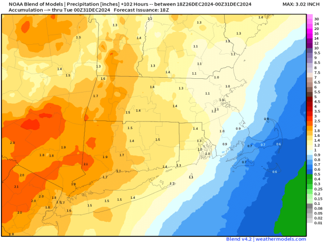
High pressure will keep us dry into Saturday, with temperatures gradually moderating, helping to melt a little bit of the snow, but we’ll see clouds start to move in Friday night and Saturday as low pressure begins to head our way. Showers will move in late Saturday and Saturday night ahead of a warm front, but across the interior, especially from central and northeastern Massachusetts into southern New Hampshire, temperatures may be near or just below freezing Saturday night, which could result in some freezing rain for a while. Keep this in mind if you are going to be out and about in those areas Saturday evening and night. Temperatures should slowly warm up Sunday morning allowing the precipitation to change to all rain, with occasional showers likely during the day on Sunday. The low pressure system itself moves in for Sunday night and Monday, bringing some steadier and heavier rain in, allowing us to put another dent into the ongoing drought. The rain moves out during the day on Monday, with some clearing possible by late in the day.

Thursday night: Gradual clearing across Cape Cod, clear to partly cloudy elsewhere. Low 12-19, milder across southeastern Massachusetts and Cape Cod.
Friday: Sunshine in the morning, clouds start to filter in during the afternoon. High 35-42.
Friday night: Becoming partly to mostly cloudy. Low 20-27, a little milder across Cape Cod.
Saturday: Mostly cloudy with a few showers around during the afternoon. High 32-39, except 40-47 across southeastern Massachusetts and Cape Cod.
Saturday night: Cloudy with some occasional showers, some freezing rain or freezing drizzle likely outside of I-495. Low 30-37 north of the Mass Pike, except 37-44 across southeastern Massachusetts and Cape Cod, with temperatures possibly rising after midnight.
Sunday: Cloudy with more showers, possibly some freezing drizzle or freezing rain across southern New Hampshire in the morning. Some steadier rain may move in late in the day. High 39-46 north of Route 2, 46-53 south of Route 2.
Sunday night: Periods of rain, some of it could be heavy. Low 37-44 during the evening, temperatures may rise overnight.
Monday: Rain ends in the morning, some clearing possible late in the day, breezy. High 48-55.