Weekend Outlook: January 17-20, 2025

We’ve got good news and bad news for the weekend forecast. Good: It’s going to turn milder and rain, to get rid of some of the snow on the ground. Bad: It’s going to turn colder and snow again.

A little “nuisance snow” is expected this evening. Image provided by the NWS office in Norton, MA.

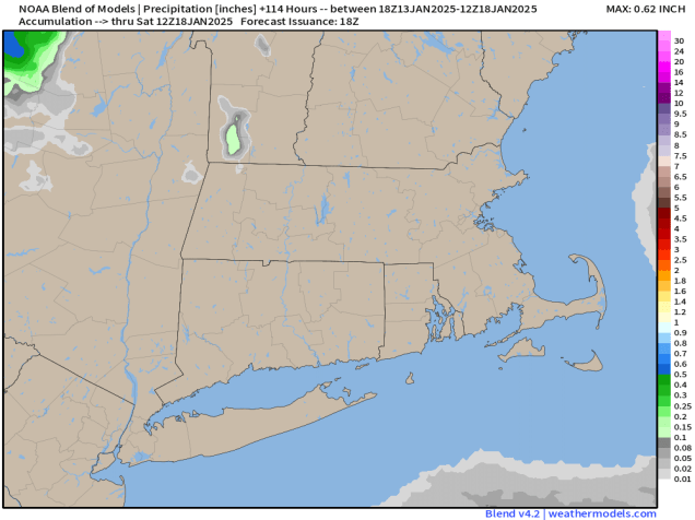
Lots of rapid changes will be happening over the next several days across the region. First, we have a weak system swing through tonight, producing some flurries and snow showers through the evening. They may coat the ground in some spots, with a little more than a coating near the South Coast and the Cape, but this is not a big deal. High pressure builds in for Friday with sunshine and seasonably chilly temperatures, but then the changes really begin. Clouds move in Friday night ahead of a strong cold front. Saturday looks to be a mild day ahead of that front, with much of the region topping 40 degrees in the afternoon. However, we’ll have some rain moving in, though it won’t be that heavy. The rain ends Saturday night as the front moves through, but that front will slow down or stall out just offshore. Sunday looks to be colder, but still near normal for mid-January with some breaks of sun in the morning, but we’ll quickly cloud back up in the afternoon.

Highs should top 40 across much of the region on Saturday. Image provided by Weathermodels.com

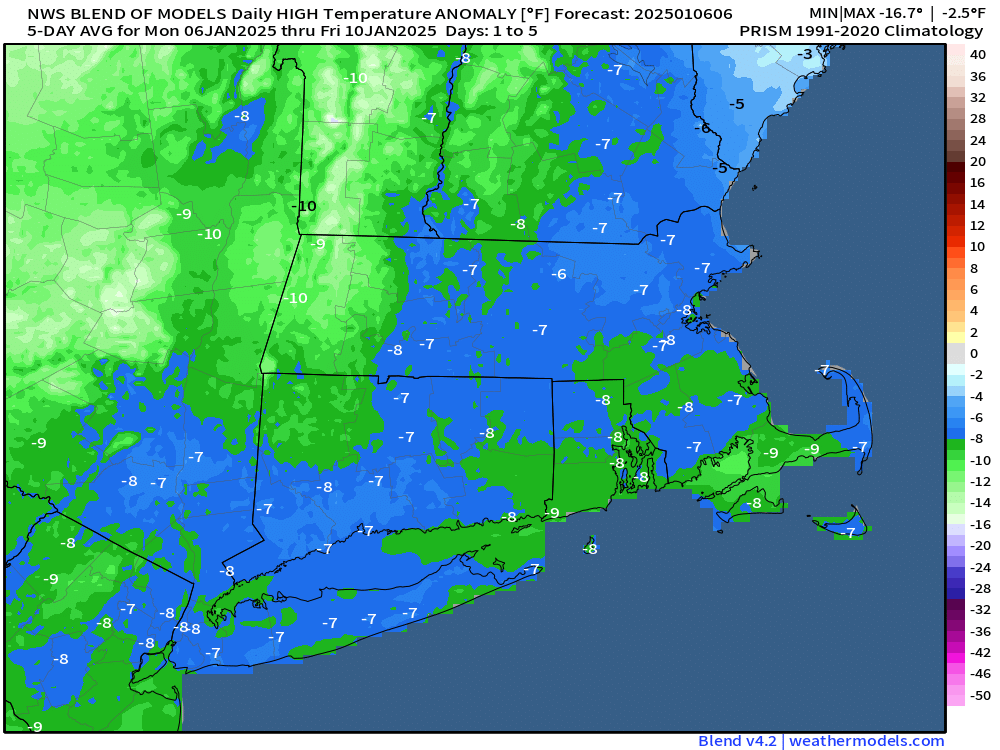
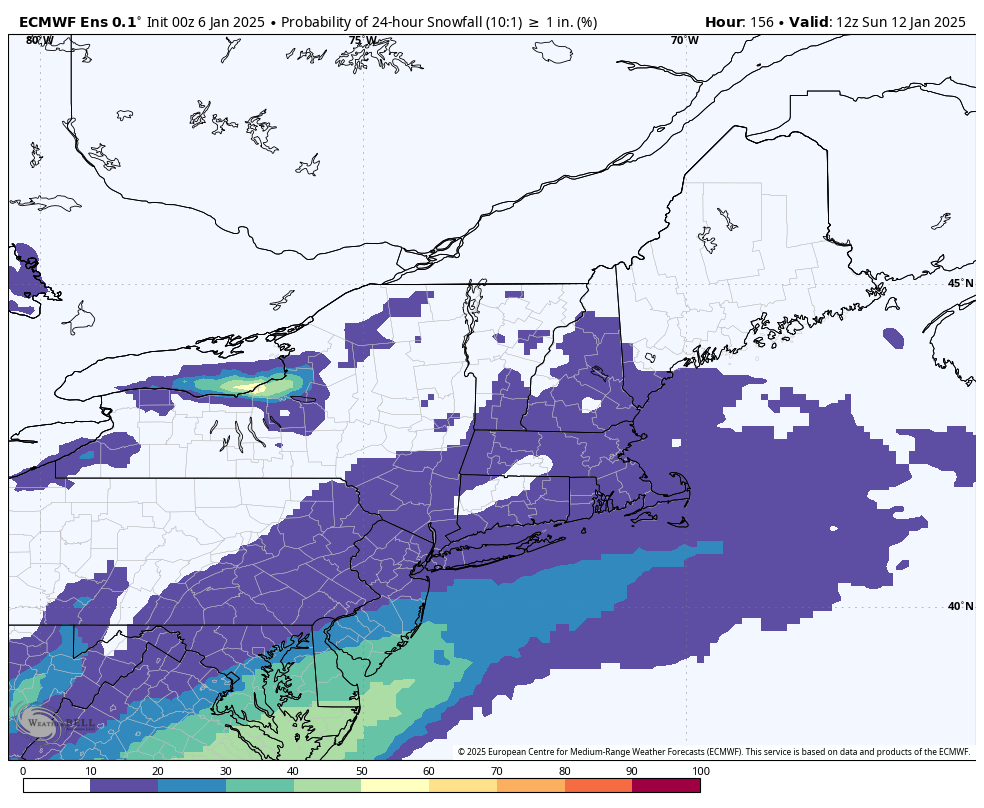
A wave of low pressure will ride along that front Sunday night, but exactly where the front stalls out will be a key part of this forecast. With that wave moving back, we’ll have a period of light snow Sunday night into early Monday. The farther offshore the front is, the lighter the amounts as you head farther inland. The closer to the coast, the better chance for some rain at the start late Sunday. In general, it’s not going to be a big storm, but many of us could see 2-4″ of new snow on the ground when you wake up Monday morning. There is the potential for a little more, especially south of Boston, but those are details we can iron out over the next couple of days. As the system pulls away on Monday, much colder air will flood into the region, with temperatures dropping during the day. Tuesday and Wednesday are going to be very cold days, with many places likely not reaching 20 for highs, and nighttime lows dropping into the single numbers or below zero. We’ll have much more detail on that in our Weekly Outlook early Monday.

You will probably need to do some shoveling Monday morning. Image provided by WeatherBell.

Thursday night: Some flurries or snow showers this evening, skies start to clear out late at night. Low 14-21.

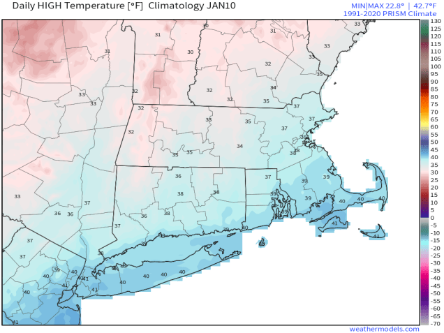
Friday: Becoming sunny. High 30-37.

Friday night: Clear during the evening, clouds start to move back in after midnight. Low 20-27 during the evening, temperatures may rise a little after midnight.

Saturday: Cloudy and breezy with rain showers developing in the afternoon. High 40-47.

Saturday night: Showers end in the evening, partial clearing after midnight. Low 27-34.

Sunday: Some morning sun, then clouds return with light snow developing before evening, some rain could be mixed in at the start across Cape Cod. High 36-43.

Sunday night: Light snow likely, ending by daybreak. Low 14-21.

Monday: A mix of sun and clouds, breezy, and turning colder. High 20-27, except 27-34 across Cape Cod and southeastern Massachusetts, but temperatures may start dropping in the afternoon.

Weekly Outlook: January 13-19, 2025

Dry weather is expected for much of the upcoming week.

Little to no precipitation is expected through Saturday morning. Image provided by Weathermodels.com

We’re starting the week off on a mild note, but that won’t last too long. A cold front moves through this evening, with some rain or snow showers accompanying it. Behind it, windy and colder weather moves back in for Tuesday and Wednesday, possibly Thursday as well. A couple of upper-level disturbances will move through over the next few days which may trigger a few widely scattered flurries, but for the most part it will be dry. Temperatures will start to moderate on Friday as high pressure moves offshore. A storm system moves through on Saturday with some rain or snow showers, then a second one follows late Sunday with some more rain or snow likely.

High temperatures may top 40 across most of the region on Saturday. Image provided by WeatherBell.

Monday: Mostly cloudy, a few rain or snow showers possible late in the day. High 36-43.

Monday night: A few rain or snow showers during the evening, clearing overnight. Low 19-26.

Tuesday: Sunshine and some afternoon clouds, breezy. High 27-34.

Tuesday night: Partly cloudy. Low 16-23.

Wednesday: Mostly sunny, breezy. High 24-31.

Thursday: Partly sunny. High 26-33.

Friday: Partly to mostly sunny. High 32-39.

Saturday: Mostly cloudy, showers likely late in the day and at night, possibly changing to snow well north and west of Boston. High 40-47.

Sunday: Intervals of clouds and sun, snow or rain possible at night. High 35-42.

Weekend Outlook: January 10-13, 2025

There is a little bit of snow in our future, but also a slight moderation in our temperatures as well.

High temperatures should be in the mid-to-upper 30s at this time of year. Image provided by Weathermodels.com
High temperatures should be in the middle-to-upper 30s at this time of year. Image provided by Weathermodels.com

The large storm system that has been sitting over Atlantic Canada for much of the week giving us gusty winds, cold temperatures, and occasional snow showers/flurries will finally loosen its grip on the region over the next day or so. Winds will finally start to diminish during the day on Friday, and temperatures will start to moderate, getting back to near to even a little normal for early January on Friday. On Saturday, the low pressure system that some of the models tried to develop into a blockbuster blizzard will pass well south of the region, with no impact at all here. However, an upper-level disturbance will move through, with some light snow or snow showers Saturday morning and into part of the afternoon. For most of the region, accumulations will be an inch or less, but a few spots could pick up 2 inches or so. Once that system pulls away, high pressure builds in with seasonably cold and dry conditions for Sunday and Monday.

Most places will receive less than 1″ of snow om Saturday. Image provided by WeatherBell.

Thursday night: Clear skies, still breezy. Low 18-25.

Friday: Lots of sunshine, winds diminish during the afternoon. High 33-40.

Friday night: Increasing and thickening clouds. Low 19-26.

Saturday: Light snow or snow showers develop in the morning, ending in the afternoon. A coating to 2 inches of accumulation is expected. High 29-36.

Saturday night: Clearing. Low 18-25.

Sunday: Mostly sunny. High 31-38.

Sunday night: Partly cloudy. Low 19-26.

Monday: Partly sunny. High 33-40.

Weekly Outlook: January 6-12, 2025

Some chilly weather, even by January standards, is expected for much of the week, but things could get complicated next weekend.

Low pressure will pass south of New England today, producing a snowstorm in Washington, DC. Loop provided by Tropical Tidbits.

A low pressure system will pass south of New England today. This is the same storm that brough blizzard conditions to Kansas City over the weekend, and a decent-sized snowstorm to Washington, DC today. Around here, it’ll just bring in clouds, and maybe a few flurries to the Cape and Islands. That storm will combine with another one over Newfoundland and remain in place for much of the week, resulting in generally dry but breezy and chilly conditions through Friday. Some weak upper-level disturbances may move through at times, generating a few snow showers here and there, but they’ll be on the light side.

Temperatures will be 5-10 degrees below normal this week. Image provided by Weathermodels.com

By the end of the week, a storm system will begin taking shape that could produce wintry weather from Texas into the Tennessee Valley at the end of the week. What it does next weekend is still a big question mark, and dependent on a few upper-level features that are still out over the Pacific Ocean, which makes things highly uncertain at this point. You may have seem some of the usual characters on social media (a.k.a. Facebook Forecasters) posting maps showing a massive blizzard impacting New England. Yes, some of the models have shown this, and yes it’s possible, but the odds of it happening at this point seem fairly low to us. There are two other scenarios shown on the models that seem more likely, at least for now. One scenario is that the system moves off the Carolina or Mid-Atlantic coastline and stays well to the south, with no impacts up here at all, similar to today’s system. A second scenario is that the storm does develop, and moves off the Mid-Atlantic coast, but stays just far enough offshore that we are only on the fringe of the storm, with some light snow for part of the region. For now, we’re going to lean towards these latter scenarios, while keeping a close eye on the development of the system, just in case, the initial scenario becomes more likely (though we don’t expect at that to be the coast). We’ll obviously have much more clarity when we publish our Weekend Outlook Thursday afternoon.

The ensembles only indicate a slight chance for a little snow next weekend. Image provided by WeatherBell.

Monday: More clouds than sun, slight chance for a flurry across Martha’s Vineyard and Nantucket, skies may start to clear out late in the day. High 23-30.

Monday night: Clouds hang around across the Outer Cape, clearing elsewhere, becoming breezy. Low 11-18.

Tuesday: A mix of sun and clouds, a stray snow shower is possible, breezy. High 22-29.

Tuesday night: Clear to partly cloudy, breezy. Low 12-19.

Wednesday: Sunshine and some afternoon clouds, maybe a snow shower, windy. High 21-28.

Thursday: Partly sunny, slight chance for a flurry, breezy. High 24-31.

Friday: Mostly sunny, not as chilly. High 31-38.

Saturday: Intervals of clouds and sun, slight chance for some light snow at night, favoring areas south of Boston. High 30-37.

Sunday: Intervals of clouds and sun with a slight chance for some light snow, mainly south of Boston. High 30-37.

Weekend Outlook: January 3-6, 2025

Colder weather is on the way as get to the first weekend of the year.

Temperatures will be below normal through the weekend. Image provided by Weathermodels.com

The forecast through Sunday is pretty straightforward. High pressure builds in with progressively colder weather through Sunday, exacerbated by gusty winds at times, but it will remain dry. Things could get a little complicated on Monday. Low pressure will move off the Mid-Atlantic coastline, producing a decent-sized snowstorm for Washington, D.C. and nearby locations. The storm will pass south of New England, but could get close enough to produce a little light snow or some snow showers near the South Coast, but this is far from a lock.

There is a very low chance for some light snow near the South Coast on Monday. Image provided by WeatherBell.

Thursday night: Clear to partly cloudy, breezy. Low 24-31.

Friday: Mostly sunny, breezy. High 32-39.

Friday night: Clear to partly cloudy. Low 18-25.

Saturday: A mix of sun and clouds, breezy. High 26-33.

Saturday night: Partly cloudy. Low 15-22.

Sunday: Partly sunny, breezy. High 25-32.

Sunday night: Partly cloudy. Low 14-21.

Monday: Intervals of clouds and sun, slight chance for a few snow showers near the South Coast. High 25-32.

Weekly Outlook: December 30, 2024 – January 5, 2025

We’re going to end 2024 on a stormy note, but 2025 begins with colder weather.

We’re starting the week off on a warm but wet note as a cold front makes its way across the region. Rain should end before midday, with gusty southerly winds keeping us mild ahead of the front. Once the front moves through, we’ll quickly clear out, but temperatures won’t drop that quickly. High pressure builds in for Tuesday with some sunshine and temperatures remaining fairly mild for late-December, but that won’t last long. Another low pressure system quickly follows, with another round of rain likely Tuesday night into Wednesday, so if you’ve got outdoor plans for New Year’s Eve make sure you bring an umbrella. This will help put another dent into the ongoing drought, but it will take a lot more rain to end that. Once that system moves out, high pressure builds in for Thursday through the weekend with breezy and colder weather, though a few flurries are possible at times.

Much of the region could pick up half an inch to an inch of rain on Wednesday. Image provided by Weathermodels.com

Normally, we don’t forecast more than a week out, but we felt that it was worth mentioning what is going to happen during the following week. You’ll see in our forecast that temperatures gradually get colder as we go through the end of this week and the weekend, but all indications are that starting next week, a much colder airmass is going to settle in, and it may remain in place for a good chunk of January. Temperatures will be below to perhaps well below normal, and there may be some days, especially toward mid-month, where high temperatures struggle to reach 20, and low temperatures could drop below zero in parts of the region. There are also some indications that next week could be stormy, with the potential for one or two storms impacting the region, but this is far less certain. It’s way too early for any details on any potential storm systems, but the cold air seems far more likely, so we figured a heads up was warranted at this point.

Temperatures could be well below normal during the first full week of January. Image provided by WeatherBell.

Monday: Rain ending in the morning, skies start to clear out in the afternoon, breezy, especially in the morning. High 50-57.

Monday night: Mostly clear. Low 32-39.

Tuesday: Morning sun gives way to increasing afternoon clouds. High 44-51.

Tuesday night: Becoming cloudy with rain likely, possibly heavy at times. Low 34-41 during the evening, temperatures start rising after midnight.

Wednesday: Cloudy and breezy with rain tapering off to showers ending in the afternoon. High 43-50.

Thursday: A mix of sun and clouds, windy, and colder. High 34-41.

Friday: Partly to mostly sunny, breezy. High 30-37.

Saturday: Partly sunny, breezy. High 28-35.

Sunday: A mix of sun and clouds, breezy. High 25-32.

Weekend Outlook: December 27-30, 2024

If you’re happy that you had a White Christmas but want the snow gone now then you’re in luck because it will turn milder this weekend, but there’s also some rain on the way, and possibly some icing issues as well.

Much of the region could pick up an inch or more of rain between now and Monday evening. Image provided by Weathermodels.com

High pressure will keep us dry into Saturday, with temperatures gradually moderating, helping to melt a little bit of the snow, but we’ll see clouds start to move in Friday night and Saturday as low pressure begins to head our way. Showers will move in late Saturday and Saturday night ahead of a warm front, but across the interior, especially from central and northeastern Massachusetts into southern New Hampshire, temperatures may be near or just below freezing Saturday night, which could result in some freezing rain for a while. Keep this in mind if you are going to be out and about in those areas Saturday evening and night. Temperatures should slowly warm up Sunday morning allowing the precipitation to change to all rain, with occasional showers likely during the day on Sunday. The low pressure system itself moves in for Sunday night and Monday, bringing some steadier and heavier rain in, allowing us to put another dent into the ongoing drought. The rain moves out during the day on Monday, with some clearing possible by late in the day.

Freezing rain could be an issue north and west of Boston Saturday night. Image provided by WeatherBell.

Thursday night: Gradual clearing across Cape Cod, clear to partly cloudy elsewhere. Low 12-19, milder across southeastern Massachusetts and Cape Cod.

Friday: Sunshine in the morning, clouds start to filter in during the afternoon. High 35-42.

Friday night: Becoming partly to mostly cloudy. Low 20-27, a little milder across Cape Cod.

Saturday: Mostly cloudy with a few showers around during the afternoon. High 32-39, except 40-47 across southeastern Massachusetts and Cape Cod.

Saturday night: Cloudy with some occasional showers, some freezing rain or freezing drizzle likely outside of I-495. Low 30-37 north of the Mass Pike, except 37-44 across southeastern Massachusetts and Cape Cod, with temperatures possibly rising after midnight.

Sunday: Cloudy with more showers, possibly some freezing drizzle or freezing rain across southern New Hampshire in the morning. Some steadier rain may move in late in the day. High 39-46 north of Route 2, 46-53 south of Route 2.

Sunday night: Periods of rain, some of it could be heavy. Low 37-44 during the evening, temperatures may rise overnight.

Monday: Rain ends in the morning, some clearing possible late in the day, breezy. High 48-55.

Weekly Outlook: December 23-29, 2024

With a little more snow on the way Tuesday morning, it looks like much of the region is going to have a White Christmas.

Tuesday’s snow shouldn’t amount to much for most of the region. Image provided by WeatherBell.

High pressure hangs on today with sunshine, but clouds start to move in later today as another Alberta Clipper moves into the Great Lakes, passing north of the region early Tuesday. We’ll see some snow showers develop tonight as a warm front ahead of the system moves in, but most of these will be north of the Mass Pike and on the light side. There may be a bit of a lull after these initial snow showers, and temperatures will start rising overnight as winds shift into the southwest. Light snow and snow showers redevelop before daybreak and continue through the morning before a cold front moves through. Across parts of the Cape Cod and possibly southeastern Massachusetts, temperatures will be near or even above freezing, so the precipitation may fall as rain or a mix of snow and rain. By the time everything winds down by early afternoon, accumulations will be on the order a coating to an inch in most places, mainly north of the Mass Pike, with the possibility for a few spots from the Merrimack Valley into southern New Hampshire seeing a little more As you head into central New Hampshire (north of Concord), some heavier amounts are possible. We’ll start to clear out later Tuesday, then a large area of high pressure builds in and remains in control right into the weekend with generally dry weather and temperatures near or a little above where they should be in late December. We’ll turn cloudy for Sunday as another low pressure system heads this way, but whether any precipitation from it makes it in on Sunday or waits until Monday remains to be seen.

The end of the weekend is a big question mark at this point. Images provided by Pivotal Weather.

Monday: Morning clouds and a few more snow showers across the Outer Cape, a mix of sun and clouds elsewhere. High 23-30.

Monday night: Becoming cloudy with some snow showers likely around midnight. Light snow and snow showers may redevelop near daybreak. Low 17-24 during the evening, temperatures start rising after midnight.

Tuesday: Morning clouds with light snow or snow showers, possibly mixed with rain across Cape Cod, some clearing develops in the afternoon. High 31-38, a little warmer across Cape Cod.

Tuesday night: Clouds hang around across Cape Cod, becoming clear to partly cloudy elsewhere. Low 15-22, milder across Cape Cod.

Christmas Day: Partly to mostly cloudy across Cape Cod with a few snow showers possible, partly sunny elsewhere. High 29-36.

Thursday: A mix of sun and clouds. High 33-40.

Friday: Partly to mostly sunny. High 35-42.

Saturday: Intervals of sun and clouds. High 37-44.

Sunday: More clouds than sunshine with a chance for showers. High 37-44.

Weekend Outlook: December 20-23, 2024

The winter solstice takes place at 4:20am Saturday, marking the official start of astronomical winter. Mother Nature is going to be sure you know that winter has arrived this weekend.

The winter solstice occurs at 4:20am Saturday. Days start getting longer from Saturday until June. Images provided by the Farmer’s Almanac.

An Alberta Clipper moves across the Great Lakes tonight, sending clouds back into the region. That system will head toward the Mid-Atlantic states and then offshore, becoming a rather potent system as it passes south and east of the region later Friday into Saturday. It may be just close enough to bring some rain or snow showers to Cape Cod, but with the counter-clockwise flow around the system, northeast winds blowing over the still relatively mild Atlantic will bring some ocean-effect snow showers to parts of our area later Friday into Friday night. This won’t be a big deal, but it may slow-down the Friday evening commute a little. Right now, it looks like most places will see less than 2 inches of snow from this system. Rain will eventually change to snow across Cape Cod, with 1-2 inches possible there as well.

A little snow is expected across the region Friday and Friday night. Image provided by Weathermodels.com

The storm pulls away on Saturday and high pressure builds in, with northerly winds ushering in some of the coldest air so far this season from later Saturday into Monday. While most of the region will be sunny and cold Sunday, the northerly winds will bring clouds back into the Outer Cape, with some additional snow showers likely that could produce additional accumulations. Monday looks dry and cold, with clouds starting to move back in late in the day ahead of the next storm system.

Wind chills will be near or below zero if you’re heading out the door early Sunday. Image provided by WeatherBell.

Thursday night: Becoming mostly cloudy. Low 24-31, little milder across Cape Cod.

Friday: Cloudy and becoming breezy with snow showers developing, except rain showers across southeastern Massachusetts and Cape Cod, changing to snow showers late in the day. High 32-39, a little milder across southeastern Massachusetts and Cape Cod.

Friday night: Mostly cloudy with scattered snow showers, breezy along the coast. Low 21-28, little milder across Cape Cod.

Saturday: More clouds than sunshine, snow showers continue across Cape Cod, but end early elsewhere, breezy. High 28-35.

Saturday night: Becoming clear and cold, except across the Outer Cape where it will remain cloudy with some additional snow showers. Low 9-16, a little milder across the Outer Cape.

Sunday: Partly to mostly cloudy with snow showers across the Outer Cape, mostly sunny, breezy, and cold elsewhere. High 19-26.

Sunday night: Plenty of clouds with a few more snow showers across the Outer Cape, clear elsewhere. Low 6-13, a little milder across the Outer Cape.

Monday: Partly to mostly sunny, clouds start to move in late in the day. High 24-31.

Weekly Outlook: December 16-22, 2024

As we head into the final week before Christmas, Hanukkah, Kwanzaa, or whatever else you celebrate, we’ve got some active weather ahead. We also will officially enter astronomical winter this week, with the Winter Solstice at 4:20am on Saturday (Meteorological Winter started on December 1).

Tuesday looks like a mild day ahead of a cold front. Image provided by Weathermodels.com.

A weak low pressure system will pass south of the region today, but with plenty of dry air in place, most of the precipitation associated with that system will dry up before it gets here, with only a few flurries or freezing drizzle possible this morning. However, another system quickly follows that one. As it heads across southern Canada, it will drag a warm front across the region this evening, with some rain expected ahead of the front tonight into Tuesday morning. Temperatures will rise behind the warm front tonight, setting up a mild day on Tuesday, though a cold front will move through in the afternoon. We’ll clear out behind that front later Tuesday, but clouds quickly return on Wednesday as yet another system heads our way. This one will bring in some more rain Wednesday night into early Thursday, however, it may be cold enough for some snow across parts of southern New Hampshire and the Merrimack Valley at the start. Everything winds down Thursday morning as the system pulls away, with clearing Thursday afternoon.

Rain may start as a little snow Wednesday night, mainly north and west of I-495. Images provided by Pivotal Weather.

Another weak system moves through on Friday with a few snow showers possible. For the weekend, we’re watching high pressure build in across southern Canada, and low pressure develop off the Mid-Atlantic states. Right now, it looks like the high will be the dominant force around here, with dry and very chilly weather, but that’s far from a lock at this point, so we’ll keep a close watch on it, in case things start to change.

At least one model shows the potential for a brutally cold day on Sunday. Image provided by WeatherBell.

Monday: Morning clouds with a flurry or some freezing drizzle possible, some afternoon sunny breaks develop. High 37-44.

Monday night: Partly to mostly cloudy with some light rain developing, becoming breezy after midnight. Low 34-41 during the evening, temperatures rise overnight.

Tuesday: Rain ends early, then a mix of sun and clouds with diminishing winds for the afternoon. High 50-57.

Tuesday night: Clear to partly cloudy. Low 30-37.

Wednesday: Becoming mostly cloudy, rain develops at night, possibly starting as snow north and west of I-495. High 42-49.

Thursday: Rain or snow ends early, skies clear out in the afternoon, breezy. High 39-46.

Friday: More clouds than sun with a few snow showers possible. High 29-36, a little warmer across southeastern Massachusetts and Cape Cod.

Saturday: A mix of sun and clouds, chance for some snow showers, mainly across Cape Cod. High 27-34, a little warmer across southeastern Massachusetts and Cape Cod.

Sunday: Partly to mostly sunny, quite chilly. High 17-24, a little milder across southeastern Massachusetts and Cape Cod.