An active weather pattern will provide us with a little bit of everything this week.
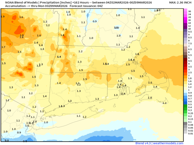
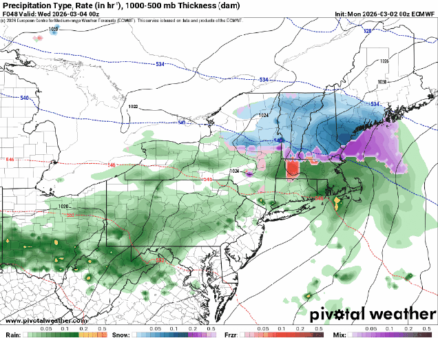
The week starts off quiet with high pressure in control giving us a rather chilly day, but that won’t last too long. A wavy frontal system will start to lift northward on Tuesday as a wave of low pressure rides along it. With cold air in place, we’ll see snow moving in Tuesday afternoon, but it will quickly change to rain south of the Mass Pike as warmer air moves in. North of the Pike, the colder air will take a little longer to scour out, but warmer air will move in aloft, so we’ll likely see a period of freezing rain Tuesday evening before a change to plain rain at night before the precipitation comes to an end. Wednesday looks like a calmer day, and likely a bit milder, with some sunshine. That front will lift northward as a warm front on Thursday, bringing us a mild day with more rain. While this will help melt some of the glacier that we still have in place, it may also cause some problems, as the ground remains frozen, so that water will have nowhere to go. While we’re not going to have widespread flooding, there could be some issues, especially along some of the rivers as the ice breaks up and starts to flow downstream, with ice jams possibly resulting in some flooding issues. The front drops southward as a backdoor cold front late Thursday and Friday, with another wave of low pressure moving along it. As the colder air moves back in, we could see a period of sleet or freezing rain across the interior once again. The front may lift back northward as a warm front on Saturday, before a stronger cold front moves in from the northwest on Sunday.
Monday: Sunshine and a few clouds. High 21-28.
Monday night: Clear and cold, clouds start to drift in late at night. Low 8-15.
Tuesday: Becoming mostly cloudy, light snow developing in the afternoon, quickly changing to rain south of the Mass Pike. High 34-41.
Tuesday night: Cloudy with rain likely south of the Mass Pike, snow changing to freezing rain and possibly plain rain north of the Mass Pike, ending before daybreak. Low 27-34 during the evening, temperatures hold steady or slowly rise overnight.
Wednesday: Clouds give way to some sunshine, chance for a few showers. High 43-50, cooler along the coast and across Cape Cod.
Wednesday night: Becoming mostly cloudy, showers developing late at night. Low 28-35.
Thursday: Cloudy with some showers likely. High 43-50.
Thursday night: Rain likely, possibly changing to sleet or freezing rain across southern New Hampshire and interior northern Massachusetts. Low 29-36.
Friday: Cloudy with some areas of freezing drizzle or sleet across the interior, plain drizzle elsewhere. High 35-42.
Saturday: Plenty of clouds with more showers, possibly some freezing rain well inland in the morning. High 47-54.
Sunday: Mostly cloudy with more showers possible. High 51-58, cooler across Cape Cod.
