The blizzard rages on today, but there are still two more chances for snow this week.
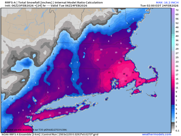
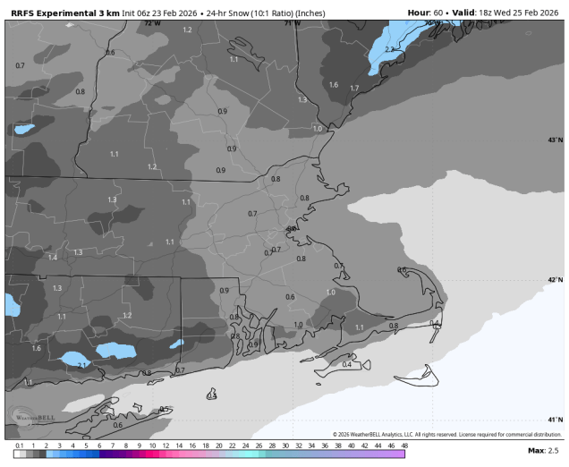
Intensifying low pressure passes south and east of New England today with heavy snow, strong winds, and coastal flooding likely. The snow will be heavy through the morning, then start to taper off in the afternoon, ending during the evening. We’re looking at 10-18 inches across much of the region, a little less across southern New Hampshire, on the order of 6-10 inches. Winds will gust to 30-50 mph inland, and 50 to perhaps 70 mph along the coast, with significant blowing and drifting snow likely. Temperatures will slowly fall during the day, so the snow will become a little fluffier, allowing the blowing and drifting to become more of an issue. Winds will start to diminish later today as the storm pulls away, but it will remain breezy into Tuesday morning. High pressure builds in with some sunshine returning on Tuesday, but it won’t last too long. Clouds come right back at night as an Alberta Clipper heads our way. Some light snow will develop towards daybreak on Wednesday, ending by early afternoon. Temperatures may be marginally warm enough for the snow to mix with or change to rain south of the Mass Pike. Overall, with it being a weak and fast-moving storm, we’re not expecting more than 1-2 inches of snow anywhere.
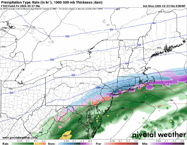
We’ll clear out at night and to start the day Thursday, but then another system quickly heads our way for Thursday night and early Friday. There’s a bit more uncertainty with this one – some models have a change to rain with the storm passing to the north, some keep the storm farther south with less rain, but a shift southward where the snow falls. Some models show light accumulations, some heavier. For now, it doesn’t look like a big storm, but we’ll see how things progress as the week goes on. High pressure brings in drier weather for later Friday and the weekend.
Monday: Windy with snow, heavy at times through the morning, tapering off during the afternoon. High 26-33, temperatures start to drop by late morning.
Monday night: Snow showers end during the evening, some late-night clearing, still breezy. Low 15-22.
Tuesday: Partly to mostly sunny, breezy. High 24-31.
Tuesday night: Clouds stream in, snow showers possible towards daybreak. Low 5-12, temperatures start to rise after midnight.
Wednesday: Light snow or snow showers, possibly mixed with rain south of the Mass Pike, ending in the afternoon. Accumulations of a coating to 2 inches possible. High 32-39.
Wednesday night: Becoming clear to partly cloudy. Low 19-26.
Thursday: Morning sun, then increasing clouds, snow possible by evening. High 33-40.
Thursday night: Cloudy with some snow or rain likely. Low 22-29.
Friday: Snow or rain ends early, skies start to clear out in the afternoon. High 34-41.
Saturday: Mostly sunny. High 39-46.
Sunday: Partly sunny. High 35-42.
