Before we get to the bad news (i.e. the rest of this blog post), we’d like to remind you that Red Sox Opening Day is just 33 days away.
Unless you’ve been unconscious for the past several days, you may have heard that we’ve got a storm on our way that the media has been going off the deep end about. As a result, we at Storm HQ are issuing an Extreme Hype Warning. When an Extreme Hype Warning has been issued, that means you’ll see blanket coverage from the network stations around here, hourly updates even when they go to regular programming, and of course, obligatory live shots from (take your pick):
- The side of an Interstate
- Logan Airport
- A local DPW salt pile
- A beach showing the rough surf and coastal flooding
- A Dunkin Donuts where they are talking to a plow operator
- All of the above
You’ll also get network reports about how the snow is creating chaos in New York City, and in some cases, but likely not this one, how it put Washington at a standstill, and possibly how it dumped heavy snow on the Midwest. The latter is debatable, because anything west of the Appalachians is considered “flyover country” to the media around here.
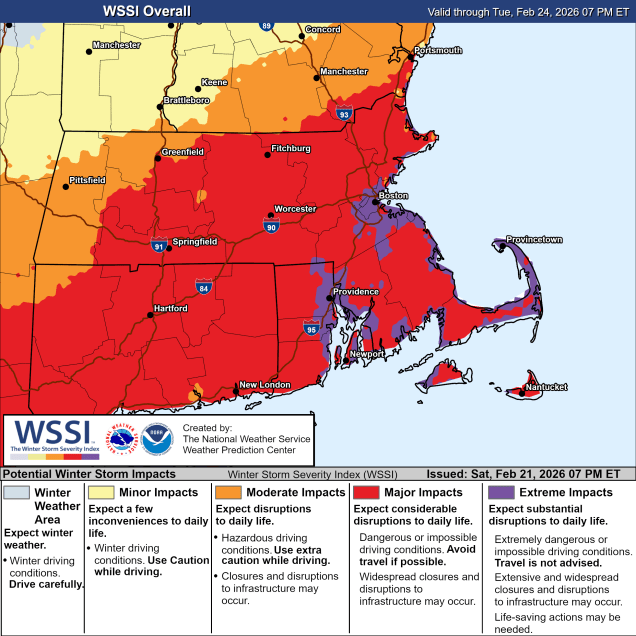
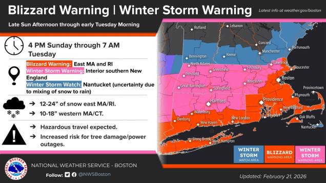
Having said that, let’s get to the details. Low pressure will move off the Carolina coastline early Sunday, then head northeastward while rapidly strengthening later Sunday into Monday, passing south and east of Nantucket late Monday. This storm will have 3 main impacts on our region: Strong winds, coastal flooding, and heavy snow. We’ll address those in order.
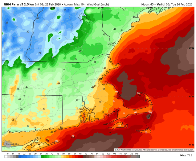
Our low pressure system, which isn’t that strong at the moment (central pressure around 1012mb – 29.88″), will quickly strengthen late Sunday and Monday, with its lowest pressure dropping to around or even under 970mb (28.64″), which is equivalent to a Category 2 Hurricane. There’s a term that sounds scary (and is overused by the media) to describe this called “bombogenesis”. All that means is that the central pressure of the storm dropped by at least 24mb over a 24-hour span – the storm “bombed out”. As the pressure drops in the storm, the gradient between it and high pressure to the north increases, which is what generates wind. The larger the difference in pressure over a smaller area, the tighter the gradient and thus the stronger the wind. The winds will start to pick up Sunday afternoon, but the strong winds are likely Sunday night into Monday morning. We’re looking at sustained winds of 20-30 mph inland, and 30-40 mph along the coast, especially from Boston southward, with sustained winds of 40-50 mph possibly across parts of Cape Cod and the South Coast. In terms of wind gusts, we’re looking at 40 to 50 mph north and west of Boston, 50-70 mph south of Boston, and perhaps to hurricane force on Cape Cod and the Islands. This will also certainly result in trees and powerlines down along with other wind damage, so be prepared for the power to go out.
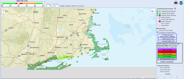
Coastal flooding is our next concern, and the wind is the primary driver of that. Tides are not astronomically high (we lucked out there!), but persistent east to northeasterly winds will continue push the ocean towards east-facing shorelines. As a result, some minor to perhaps moderate coastal flooding is expected with the high tides by Monday morning and Monday afternoon along the coast of eastern Massachusetts, especially the usually vulnerable locations. As winds shift into the north behind the storm later Monday, the threat will diminish across eastern Massachusetts, but will increase across places with north-facing coastline, like Cape Cod, Martha’s Vineyard, and Nantucket.
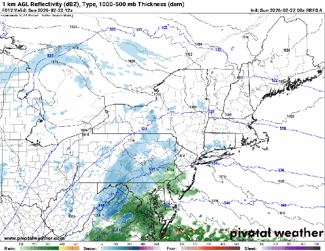
This brings us to the part most of you want to hear about – snow. There may be a few flurries around during the afternoon along the coast as northeast winds start to increase and pick up a little moisture from the ocean, but the steady snow associated with the storm itself will move in from southwest to northeast as early as 5pm in parts of southern Rhode Island, and as late as 10pm or so into southern New Hampshire. The intensity will quickly pick up, with moderate to occasionally heavy snow overnight. Right now the heaviest snow, possibly falling at a rate of 1-3 inches per hour, looks to be during what would normally be the morning commute, 5-10am. After that, it will taper off a little, but light to occasionally moderate snow will continue through the afternoon, likely ending from west to east between 6 and 8pm.
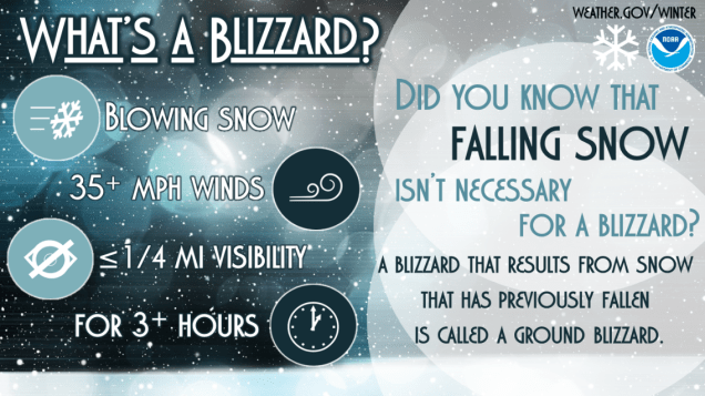
When you factor in the wind, we’ll have blizzard conditions, especially near the coast, where Blizzard Warnings have been issued. The amount of snow a storm produces has nothing to do with whether it is a blizzard or not. In fact, you can have Blizzard conditions without any snow falling at all! To qualify as a blizzard, you must have sustained winds of 35 mph or frequent gusts to 35 mph or more AND visibility of 1/4 mile or less for 3 consecutive hours. We could very well get this combination, especially along the coast, Monday morning. Travel is not recommended on Monday at all, at least until conditions start to improve late in the day.
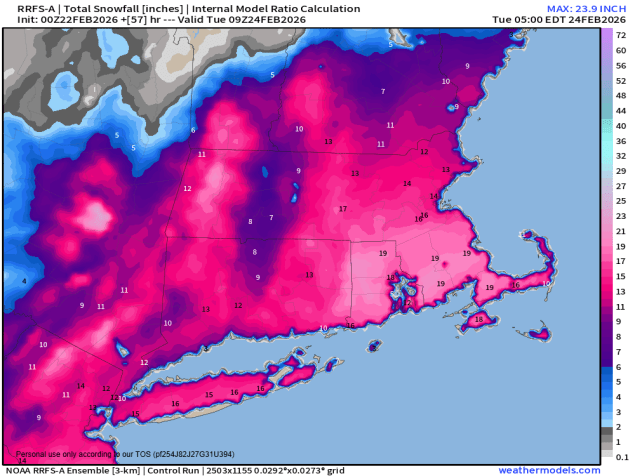
So, how much snow are we expecting? There are plenty of people out there more than willing to share model forecast maps showing widespread 20-30 inch amounts, but we’re not buying that. As a colleague of ours pointed out online earlier, this will be a heavy, wet snow, so it won’t pile up as quickly (but will be a huge pain to shovel!), plus, there probably won’t be enough precipitation to generate that much snow. Could it happen? Sure, it could, but right now, we’re not expecting. What we are expecting is widespread 10-18″ across most of eastern Massachusetts and Rhode Island, with 8-14″ across southern New Hampshire. As is usually the case, there will be some isolated heavier amounts in these regions where bands of heavy snow stick around a little longer.
While you’re digging out from this storm, other systems may produce a little more snow Wednesday and again Friday. We’ll detail those in our Weekly Outlook early Monday morning.
