This weekend will be something of a rarity for this winter – no big snowstorms and no bitterly cold temperatures.
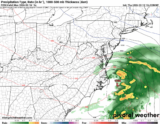
High pressure will build in, keeping us dry and seasonably cool into Friday night. A weak system will move across the region early on Saturday, but it won’t have much moisture to work with. It could produce a few flurries, but for the most part, we’ll stay dry. High pressure returns later Saturday into Sunday, then we’re going to be watching a storm system moving out of the Mid-Atlantic states. This storm was the subject of plenty of hype earlier this week, but that hype seems to have gone away. Perhaps because most of the models keep the storm well south of New England now, with little to no impact other than some clouds later Sunday into Monday? Sure, there are still 1 or 2 outlier models that bring a little snow to parts of Southern New England, but they are just that – outliers. Unless something radically changes in the next day or two, our forecast will show it staying dry.
Thursday night: A few clouds around. Low 10-17.
Friday: Mostly sunny. High 30-37.
Friday night: Becoming partly to mostly cloudy, chance for a few late-night flurries. Low 14-21.
Saturday: Morning clouds, maybe a flurry, then becoming partly to mostly sunny in the afternoon. High 33-40.
Saturday night: Clear to partly cloudy. Low 15-22.
Sunday: Mostly sunny in the morning, then increasing afternoon clouds. High 31-38.
Sunday night: Partly to mostly cloudy. Low 15-22.
Monday: Intervals of clouds and sun. High 34-41.
