Once the snow finally winds down today, chilly weather will move back in for much of the week.
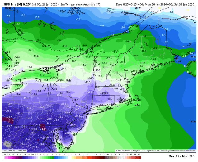
Low pressure will slowly pull away from the region today, with occasional light snow or snow showers for a good chunk of the day, especially north of the Mass Pike, where additional accumulations of 2-4 inches are possible (less is expected to the south). We’ll see some clearing tonight, but clouds will fill back in on Tuesday as an upper-level disturbance crosses the region, keeping temperatures on the chilly side. Another disturbance moves in on Wednesday, which may produce a few snow showers late in the day and at night. High pressure then builds in with dry and cold conditions for the latter half of the week and into the weekend. We are keeping an eye on an ocean storm late in the weekend. It’s too early to tell whether it will stay offshore with no impact or pass close enough to bring us more snow on Sunday.
Monday: Cloudy with occasional light snow and snow showers, ending by evening, breezy along the coast. Additional accumulation 2-4″ north of the Mass Pike, less than 2″ south of the Pike. High 19-26 north and west of Boston, 27-34 in the morning south of Boston with temperatures falling through the day.
Monday night: Any lingering snow showers end in the evening, becoming clear after midnight, breezy. Low 4-11.
Tuesday: Sunny in the morning, becoming partly to mostly cloudy in the afternoon. High 17-24.
Tuesday night: Becoming clear. Low -1 to +6, warmer across Cape Cod.
Wednesday: Morning sun, then clouds return. High 16-23.
Wednesday night: Partly to mostly cloudy, slight chance for a snow shower. Low -1 to +6, warmer across Cape Cod.
Thursday: Intervals of clouds and sun. High 16-23.
Thursday night: Becoming clear. Low -3 to +4.
Friday: A mix of sun and clouds. High 13-20.
Saturday: Mostly sunny. High 19-26.
Sunday: Intervals of clouds and sun, chance for snow. High 24-31.
