You may have heard that there’s a little storm on the way. Well, before that happens, it’s also going to get ridiculously cold. We’ll get to all of that in this blog, but we’ll tell you right now, you won’t find a forecast for snow amounts. It’s too early for that, and there’s too much uncertainty still. We’ll tell you how we think the storm will evolve and its likely impacts around here, how cold it will get Before the Storm (and how that will impact things), and lots of musical references, but we’re not going to give you a snowfall forecast. We may do that in another blog post tomorrow, but for now, we’ll leave the hype to all of the TV meteorologists and Facebook Forecasters of the world.
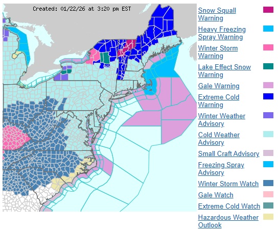
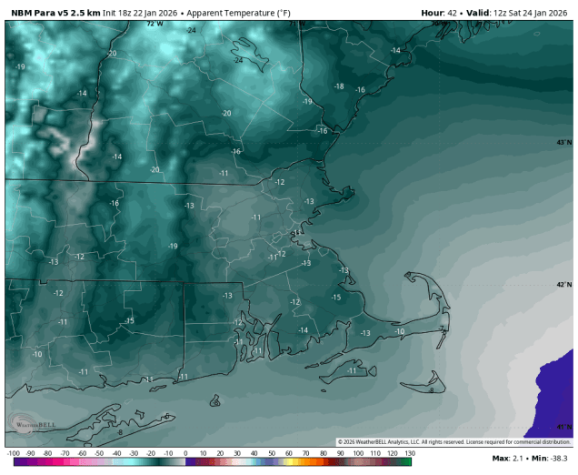
After a somewhat mild day today, a cold front will move through this evening, possibly accompanied by a few snow showers, but the more noticeable effect will be cooler air moving in tonight. On Friday, an arctic cold front will cross the region, possibly with some additional snow showers or squalls, and that is what will start the Change in the Weather. Bitterly cold air will flood into the region behind that front. Temperatures will plunge into the single numbers and below zero across the region, with wind chills well below zero thanks to gusty northwest winds, making you dream about those Hot Summer Nights. A Cold Weather Advisory is in effect for much of the region. On Saturday, sunshine will start to fade as high Clouds Race Across the Sky, but it will remain Stone Cold, with high temperatures only getting into the teens at best, with wind chills still near or below zero before winds die down in the afternoon. Clouds will continue to stream in Saturday night, but it will remain chilly. This brings us to Sunday.
Low pressure moving into the Southwest will run into the arctic airmass covering much of the eastern two-thirds of the nation over the next few days. Moderate to heavy snow is expected from the Southern Plains across to the Tennessee Valley and parts of the Southeast and Mid-Atlantic states. To the south of these areas, a significant sleet and freezing rain storm is likely from parts of Texas into the Deep South. Places like Dallas, Little Rock and perhaps Nashville and Atlanta could be Trapped Under Ice by the end of the weekend. By Sunday, that system will move off the Carolina coast and head northeastward, developing as it passes south and east of Cape Cod early Monday. Sunday will start off cloudy and cold, with snow likely moving in by mid-to-late afternoon from southwest to northeast. With some very cold air in place, it will be more of a fluffy snow, easier to clean up, but it also piles up a lot more quickly. Snow will continue through the night, possibly heavy at times, slowly winding down during the day on Monday. The questions now are:
- How much does the very dry air in place slow down the start of the snow on Sunday?
- How heavy does the snow fall at times Sunday night into Monday?
- When will the snow actually end?
- How close will the system actually track to the coast?
- Will temperatures get up close to freezing across parts of southeastern Massachusetts behind a coastal front?
- Could there be some sleet and/or rain near the South Coast and Cape Cod?
With this many questions that we don’t have answers to at this point, it would be irresponsible to try and forecast snowfall totals, so we won’t do that. We will say that it is likely that much of the region gets 6 inches or more, but beyond that, we won’t commit to anything else.
Thursday night: Partly to mostly cloudy, chance for a few snow showers, skies start to clear out late at night. Low 16-23.
Friday: A mix of sun and clouds, chance for some snow showers or squalls, breezy. High 27-34.
Friday night: Becoming clear, breezy, and bitterly cold. Low -3 to +4, a little milder across Cape Cod.
Saturday: Sunny and breezy in the morning, high clouds stream in during the afternoon. High 10-17.
Saturday night: Becoming mostly cloudy. Low -1 to +6.
Sunday: Cloudy with snow developing by mid-to-late afternoon. High 13-20 north and west of I-95, 21-28 south and east.
Sunday night: Snow likely, possibly mixed with a little sleet or rain near the South Coast and Cape Cod, becoming breezy. Low 8-15 north and west of I-95, 16-23 south and east.
Monday: Snow gradually ending, breezy. High 16-23 north and west of I-95, 24-31 south and east.

a sensible approach unlike the TV panic mongers…! I like that…
LikeLike