Warmer weather is on the way, but first we’ll have to deal with some wintry weather.
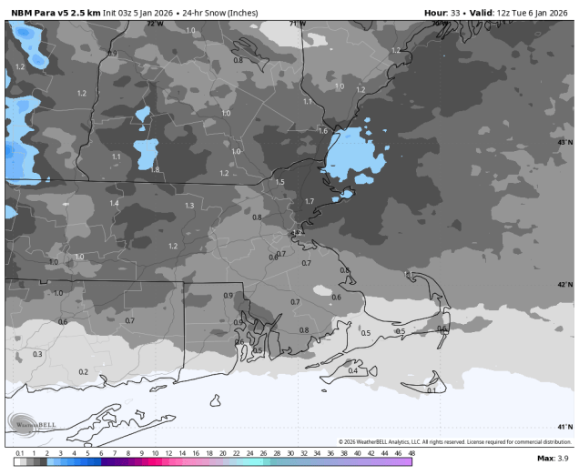
The week starts off on a chilly note, but a weak low pressure system heading our way will bring in some light snow this evening and overnight. Accumulations of a coating to 2″ are likely north of the Mass Pike, with less than 1″ south. The system moves offshore, but another one quickly follows by late Tuesday. Warmer air will be moving in aloft, which may result in some freezing rain developing Tuesday night north and west of Boston, with just rain showers elsewhere. The warmer air may take its time to move inland at the surface, so freezing rain may continue into the morning hours, before everything winds down towards early afternoon. High pressure briefly builds in for Thursday with milder conditions, then another system heads our way for the end of the week. This one should be just rain for most of the region, starting Friday afternoon, but probably not ending until a cold front moves through Saturday evening. It probably won’t be raining the entire time from Friday afternoon through Saturday evening, but there probably won’t be extended dry periods either. High pressure returns with colder weather for Sunday. An early look at the weather for kickoff of the Pats/Chargers playoff game Sunday evening shows dry weather with breezy conditions, temperatures in the middle to upper 30s, and wind chills in the upper 20s to lower 30s.
Monday: Some morning sun, then becoming cloudy with light snow developing late in the day. High 22-29.
Monday night: Mostly cloudy with light snow ending. Up to 2″ expected north of the Mass Pike, 1″ or less to the south. Low 17-24.
Tuesday: Partly to mostly cloudy, some rain possible by evening, freezing rain north and west of Boston. High 31-38, a little milder near the South Coast and Cape Cod.
Tuesday night: Freezing rain likely north and west of Boston, rain showers elsewhere. Low 27-34 during the evening, temperatures hold steady or rise a little overnight.
Wednesday: Freezing rain changing to rain showers before ending north and west, rain showers elsewhere ending in the afternoon. Some late-day clearing possible. High 38-45, a little warmer near the South Coast and Cape Cod.
Wednesday night: Becoming partly cloudy to clear. Low 26-33.
Thursday: Mostly sunny. High 39-46.
Thursday night: Increasing clouds. Low 25-32.
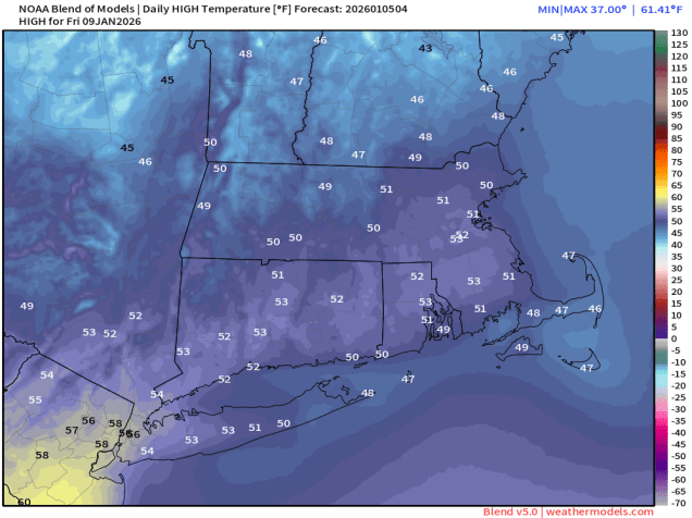
Friday: Mostly cloudy with showers developing. High 43-50.
Saturday: Cloudy with occasional showers, ending at night. High 44-51.
Sunday: A mix of sun and clouds, breezy. High 39-46.
