An active weather pattern will remain in place, but big changes are on the way in the temperature department.

High pressure builds in tonight with skies clearing out and winds diminishing, resulting in a rather chilly night, with much of the region likely dropping below freezing. Clouds quickly return on Friday as a frontal system heads our way. Winds shift into the southwest ahead of the system, so it’ll be a milder day. The front brings in some showers Friday night, ending early Saturday morning, with some clearing in the afternoon. Once again, temperatures could top 60 in many places if we can get enough sun during the afternoon.
Clouds quickly return on Sunday as another system heads into the Great Lakes. We’ll see rain developing Sunday afternoon, continuing into Sunday night as a secondary area of low pressure develops and passes close to or across Cape Cod. As that system moves into the Gulf of Maine on Monday it will intensify, bringing an end to rain. Gusty northwest winds behind the system will usher much cooler air into the region for the first part of next week.

Thursday night: Becoming clear with diminishing winds this evening, a few clouds move back in late at night. Low 26-33.
Friday: Becoming partly to mostly cloudy, breezy in the afternoon. High 51-58.
Friday night: Cloudy, breezy during the evening, showers developing. Low 45-52 during the evening, temperatures rise a little overnight.
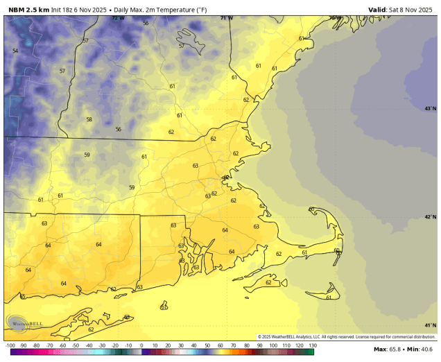
Saturday: Morning showers, then becoming partly to perhaps mostly sunny in the afternoon. High 56-63.
Saturday night: Partly cloudy. Low 36-43.
Sunday: Becoming mostly cloudy, rain develops in the afternoon. High 52-59.
Sunday night: Cloudy with showers likely. Low 41-48.
Monday: Mostly cloudy with showers gradually ending. High 52-59.
