Some unsettled weather is on the way for the 2nd half of the week for our region. Meanwhile, Jamaica is going to get walloped by Hurricane Melissa.

We start the week off with dry and cool conditions thanks to a large area of high pressure of eastern Canada. However, with an upper-level low still overhead we’ll see clouds popping up today with just a slight chance for a shower, mainly across Cape Cod where northerly winds could generate a few ocean-effect showers. As we head into Tuesday, low pressure will move off the Carolina coast and head out to sea well south of New England. However, the gradient between the developing low and the high to our north will result in northeast winds, bringing some moisture in from the Atlantic. This will result in some clouds, and possibly a few showers or some drizzle across eastern Massachusetts from late Tuesday into Wednesday.

By late Wednesday, we’ll start to watch a low pressure area developing in the Tennessee Valley. It should head northeastward, but there is still quite a bit of uncertainty with this system. We’ll likely see some rain move in from this system on Thursday, ending Friday morning, which would result in dry weather for trick-or-treating Friday evening. But that’s not the entire story. It’ll likely be rather breezy with this storm, taking down a lot of the remaining leaves on the trees. As a result, if we get enough rain, it’ll result in some slick roads with the wet leaves covering them, as well as areas of poor drainage flooding. But wait, there’s more! We’ll also be keeping an eye on what remains of Hurricane Melissa (more on that in a moment). The system should be heading well out to sea, but it could be just close enough to the East Coast for our developing system to tap into it, and infuse some tropical moisture, which would result in much heavier rain from this system. This scenario is not looking that likely at this time, but it is a possibility, so we felt the need to mention it. An upper-level low pressure area will then move in for the weekend with breezy and cooler conditions.

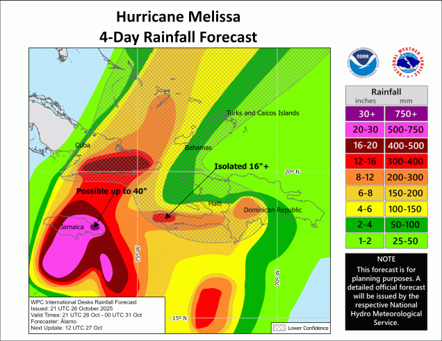
In the Caribbean, Hurricane Melissa is assaulting Jamaica and nearby portions of Cuba and Haiti, and this will continue for another day or two. As of 2am, Melissa was centered about 130 miles south-southwest of Kingston, Jamaica, drifting toward the west at 5 mph. Maximum sustained winds were near 150 mph, making Melissa a Category 4 storm. Unfortunately, the forecast for Jamaica is rather grim. Melissa will drift westward for another day or so, with some additional strengthening expected. That means rain and strong winds will continue to increase across Jamaica. By Monday night, the storm will start to turn more toward the north as a trough of low pressure off the Southeast begins to pick the storm up. That means it will likely cut right across the island, possibly as a Category 5 storm. In addition to sustained winds possibly in excess of 150 mph, a storm surge of up to 15-20 feet east of the center will likely result in widespread damage, including the capital city of Kingston. On top of that, rainfall totals of 20-40 inches (or higher) will result in catastrophic flooding and mudslides. Torrential rain and strong winds are also likely across portions of Haiti and eastern Cuba, especially as Melissa turns northward towards these areas. It will then cross the Turks and Caicos and parts of the Bahamas as it continues to slowly weaken. By mid-week, it could be a threat to Bermuda as well, possibly still at hurricane strength.
Monday: Morning sun with some afternoon clouds, slight chance for a shower or two, especially across Cape Cod. High 48-55.
Monday night: Clear skies north and west of Boston, partly to mostly cloudy south with a few showers or drizzle possible. Low 34-41, a little milder across Cape Cod.
Tuesday: Intervals of clouds and sun, breezy, chance for a few showers or some drizzle near the coast. High 49-56.
Tuesday night: Partly to mostly cloudy with some showers or drizzle around. Low 36-43, a little milder across southeastern Massachusetts and Cape Cod.
Wednesday: More clouds than sun, breezy, some additional showers or drizzle near the coast. High 49-56.
Wednesday night: Mostly cloudy, chance for a few showers. Low 38-45, a little milder across Cape Cod.
Thursday: Plenty of clouds, breezy, rain developing. High 54-61.
Thursday night: Periods of rain, breezy. Low 44-51.
Friday: Cloudy and breezy with rain ending. High 54-61.
Saturday: A mix of sun and clouds, breezy. High 51-58.
Sunday: Partly sunny. High 52-59.
