It’s going to feel like summer for a few more days, but you’ll be trading the flip-flops for sweatshirts later this week.
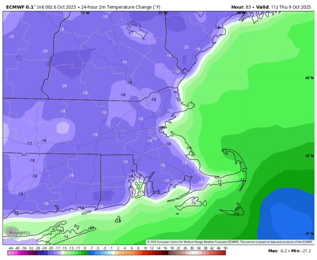
High pressure remains on control to start the week with more sunshine and unseasonably warm temperatures. Many locations away from the South Coast will top 80 again today, with a seabreeze keeping the South Coast and Cape Cod in the 70s. Tuesday looks like another warm day with gusty southwest winds, but clouds will be on the increase ahead of an approaching cold front. That front will bring in some much-needed rain late Tuesday night into Wednesday, with temperatures getting back closer to normal for early October thanks to the cloudcover and rain. The front settles offshore later Wednesday and high pressure starts to build back in. Much cooler air moves in for Thursday, with many spots likely staying in the 50s all day.
We’ll stay on the cooler side for Friday and Saturday, but temperatures will be a little closer to normal, as winds shift back into the southwest with the high sliding offshore. Sunday is a bit of a question mark at this point. A low pressure area will be developing off the Mid-Atlantic coastline. Some models try and bring it northward, bringing in some additional much-needed rain, while other models have it stay off to the south with the high to the north blocking it. We’re going to lean toward the latter scenario for now (“When in drought, leave it out”), but this is something we’ll be keeping an eye on as the week progresses.

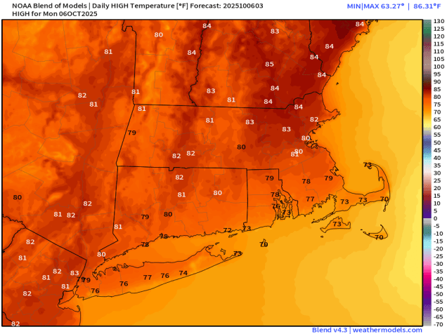
Monday: Patchy morning fog, otherwise plenty of sunshine with a few afternoon clouds. High 79-86, except 71-78 across the South Coast and Cape Cod.
Monday night: Clear to partly cloudy with a little patchy fog again. Low 53-60.
Tuesday: Mostly sunny in the morning, increasing and thickening clouds in the afternoon, breezy. High 74-81, a little cooler near the South Coast and Cape Cod.
Tuesday night: Mostly cloudy, showers developing after midnight. Low 57-64.
Wednesday: Rain likely during the morning, tapering off from northwest to southeast during the afternoon, some clearing late in the day, especially north and west of Boston, breezy. High 63-70 in the morning, temperatures start dropping in the afternoon.
Wednesday night: Becoming clear. Low 38-45, a little milder across Cape Cod.
Thursday: Lots of sunshine. High 54-61.
Thursday night: Clear skies. Low 33-40, a little milder in urban areas and across Cape Cod.
Friday: Mostly sunny. High 57-64.
Saturday: A mix of sun and clouds. High 60-67.
Sunday: More clouds than sun with a chance for showers, especially late in the day, becoming breezy. High 58-65.
