Quieter weather is on the way for the weekend around here, but the Atlantic is anything but quiet right now.

A cold front will push offshore tonight, with the much-needed rain finally coming to an end. However, that front is going to stall out south of New England, so skies will only slowly start to clear out on Friday as high pressure builds in. Saturday looks to be a pretty nice day with sunshine and mild temperatures, however, another wave riding along that stalled out front will send some clouds back in by late in the day. While most of the rain associated with that wave will stay offshore, there is the chance that some showers could reach the South Coast Saturday night and early Sunday. As that wave starts to pull away on Sunday skies will only slowly clear out. High pressure returns on Monday with more sunshine and mild temperatures.

Meanwhile, in the Atlantic, we have two named storms and a third that likely will be named in the next few days. We’ll start with Hurricane Gabrielle, which still has maximum sustained winds near 75 mph. It is centered about 385 miles west of the Azores, moving toward the east at 31 mph. A Hurricane Warning is in effect for the Azores at this time. Gabrielle will cross the Azores tonight and early Friday, then will likely become extratropical and weaken over cooler waters as it approaches the coast of Portugal this weekend.

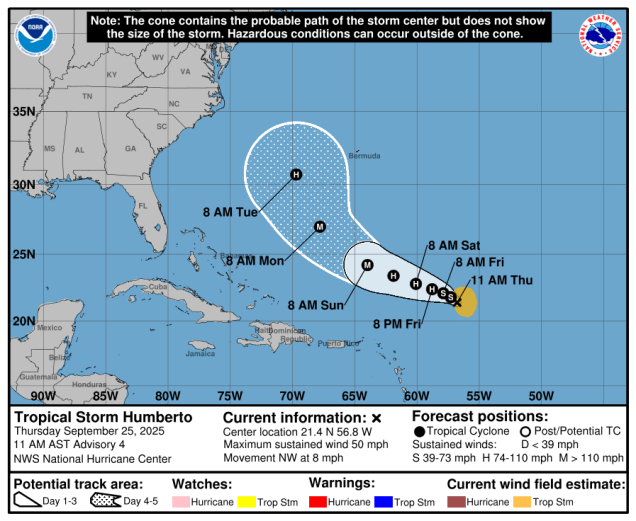
A little closer to home is Tropical Storm Humberto, which now has maximum sustained winds near 50 mph. It is centered about 465 miles east-northeast of the Northern Leeward Islands, moving toward the northwest at 8 mph. Humberto is expected to strengthen into a hurricane on Friday, and could become a pretty potent storm this weekend as it passes well north of the Greater Antilles. The current forecast shows that it should turn more toward the northwest and eventually north as it reaches the western edge of a ridge of high pressure, passing west of Bermuda early next week. However, Humberto’s future isn’t quite that simple. We’ll get into that a bit more later.
The more immediate concern is with a tropical wave crossing Hispaniola and the Turks and Caicos this afternoon. This system has been producing squally conditions across the northeastern Caribbean for the past day or two, and will continue to do so as it moves northwestward over the next few days. The system could consolidate into an area of low pressure tonight or Friday as it moves into the Bahamas. The storm may become a tropical depression or tropical storm this weekend, and if it does, it would be named Imelda. The future of this system is a lot murkier than the others. It will be traversing the very warm waters of the Gulf Stream, and upper-level conditions should be favorable, so the system could intensify pretty rapidly, but where it goes is still a giant question mark. Forecast models always struggle with systems that haven’t developed yet, and they already have a wide range of solutions for this system. Complicating that is the fact the Humberto will not be that far away, and there is the potential for the storms to interact with each other. This could alter the tracks of both storms,, making for even higher uncertainty that usual.

While the track will obviously dictate what effects this system would have on land, there are bigger concerns. A frontal system will stall out near the region, bringing some heavy rain into parts of the Mid-Atlantic states and the Carolinas. With this system likely to be at least nearby for a couple of days to start the week, there is the potential for some very heavy rain across parts of the Carolinas and Mid-Atlantic states. In fact, some models show the potential for as much as 5-10 inches (or more) of rain over the next week. While the region has been in a drought, that much rain at once will likely lead to widespread significant flooding. Parts of this region experienced devastating flooding just one year ago from Hurricane Helene, and still have not recovered. This would be a significant setback to those recovery efforts.

Thursday night: Rain ending, remaining cloudy overnight. Low 60-67.
Friday: Morning clouds give way to some afternoon sunshine. High 74-81.
Friday night: Clear to partly cloudy. Low 55-62.
Saturday: Morning sun, then clouds return in the afternoon. High 71-78, coolest along the coast.
Saturday night: Mostly cloudy, chance for a few showers, mainly near the South Coast. Low 55-62.
Sunday: Any linger showers near the South Coast end early, otherwise plenty of clouds with some afternoon sun developing, especially north of the Mass Pike. High 73-80.
Sunday night: Partly cloudy. Low 54-61.
Monday: A mix of sun and clouds. High 74-81.
