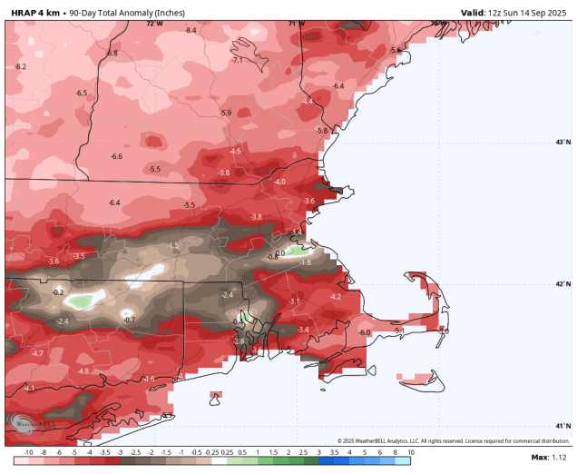
We’re not going to get much, if any, relief for the drought this week across the majority of the region, but temperatures should remain comfortable.
We start the week off with high pressure in control, giving us a couple of dry and warm days for Monday and Tuesday, with a seabreeze keeping coastal areas a little cooler, especially today. Wednesday and Thursday are the days with the most uncertainty at this point. We’ll still have high pressure to the north, but a low pressure area will be passing offshore. This will send in some clouds, but similar to last week’s system the question is how far north the rain shield will get. Some models keep it all offshore, several bring it up to the South Coast, some bring in farther inland. Given then the models overestimated how far inland it would get with the system last week, we’re inclined to think that the rain probably won’t get much farther inland than the South Coast, with most of it falling Wednesday night into early Thursday. The system pulls away later Thursday, then a cold front drops down from the north on Friday. The models show most of the rain with the front drying up before it gets here, so the front should move through with little fanfare on Friday. Behind it, high pressure returns with much cooler air on Saturday, though temperatures should start to moderate a bit on Sunday.

Monday: Areas of morning fog, otherwise partly to mostly sunny. High 71-78, a little cooler along the coast.
Monday night: Partly cloudy, areas of fog developing. Low 50-57.
Tuesday: A mix of sun and clouds. High 70-77, a little cooler along the coast.
Tuesday night: Partly to mostly cloudy. Low 50-57.
Wednesday: More clouds than sun, chance for a few showers, mainly near the South Coast. High 69-76.
Wednesday night: Partly to mostly cloudy, chance for a few showers near the South Coast. Low 54-61.
Thursday: Morning clouds, maybe a shower near the South Coast, becoming mostly sunny during the afternoon. High 75-82, a little cooler across Cape Cod.
Thursday night: Mostly clear. Low 55-62.
Friday: Partly to mostly sunny. High 76-83.
Saturday: Plenty of sunshine, cooler. High 63-70.
Sunday: Mostly sunny. High 65-72.
