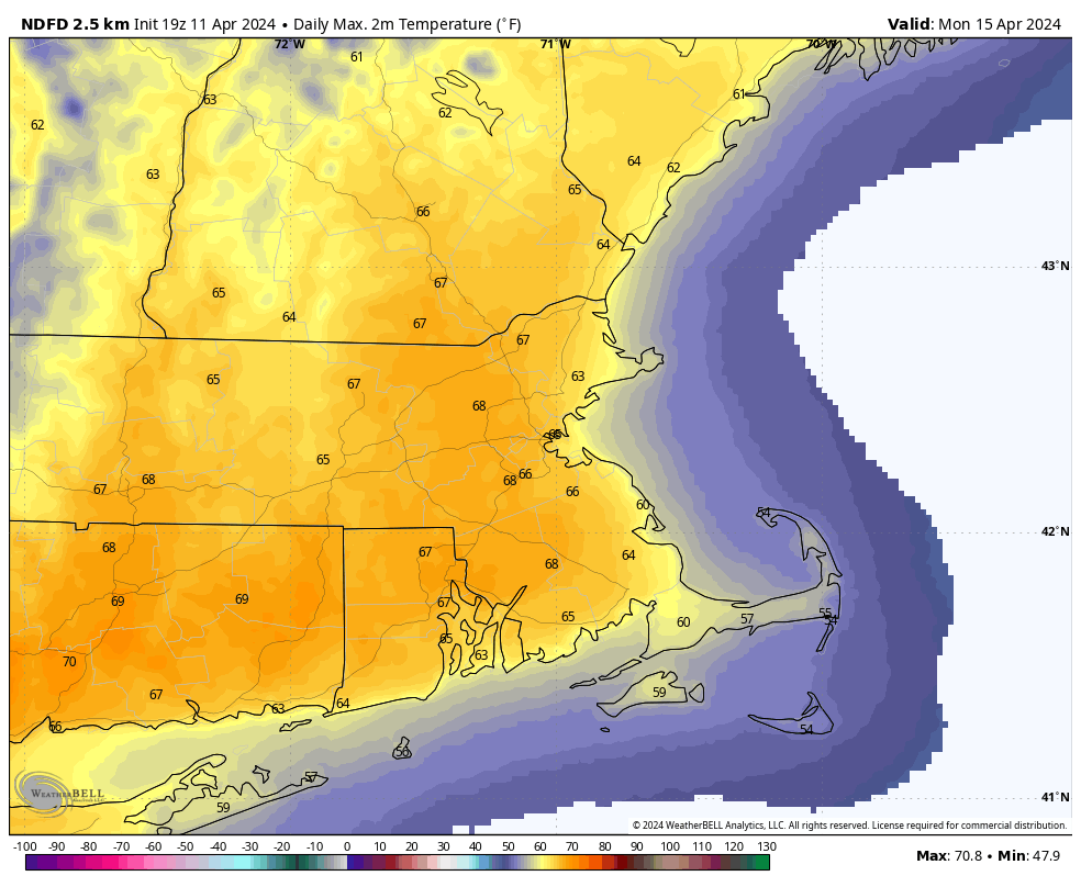
Our last sign that winter is over arrives this weekend – Marathon Monday, and we’ll have some rather nice weather for it as well.
The weather won’t be so nice for the few days leading up to it this weekend, but that’s typical of Spring in New England. A strong low pressure system is heading for the Ohio Valley this afternoon, sending a warm front our way. Some showers will accompany that front this evening, with temperatures rising overnight behind it. We’ll also have some gusty southerly winds ushering that warmer air in. Showers will become a steadier and heavier rain overnight, which will renew flooding concerns once again for much of the region. The low pressure system will send a cold front through Friday morning. Ahead of it, there could be a line of thunderstorms developing, with some more heavy rain and gusty winds. Everything should wind down during the afternoon, with some clearing possible late in the day. However, an upper-level low will move across the Northeast on Saturday, keeping plenty of clouds and gusty winds around with a few more showers possible, especially during the morning. We’ll see some clearing for Saturday night, but clouds quickly return on Sunday as yet another weak system heads our way. This one will bring in another round of rain showers late Sunday and Sunday night, mainly south of the Mass Pike. That system pulls away late at night, and high pressure builds in for Patriots Day on Monday with sunshine, breezy conditions, and mild temperatures. Normal high temperatures for mid-April are in the middle to upper 50s, but we should be about 5-10 degrees warmer than that.
Thursday night: Showers redevelop, becoming a steady rain after midnight, becoming windy. Low 48-55 this evening, temperatures may rise a bit after midnight.
Friday: Rain, possibly a thunderstorm, during the morning, taper off to showers and ending early afternoon with some late-day sunny breaks possible, windy. High 57-64.
Friday night: Becoming partly cloudy, breezy. Low 41-48.
Saturday: Partly to mostly cloudy, windy, chance for a few showers, mainly in the morning. High 50-57.
Saturday night: Becoming partly cloudy, breezy. Low 38-45.
Sunday: Morning sun, then clouds return, with some showers possible late in the day, breezy. High 56-63.
Sunday night: Showers likely during the evening, skies start to clear out late at night. Low 41-48.
Monday: Plenty of sunshine, breezy. High 60-67.
