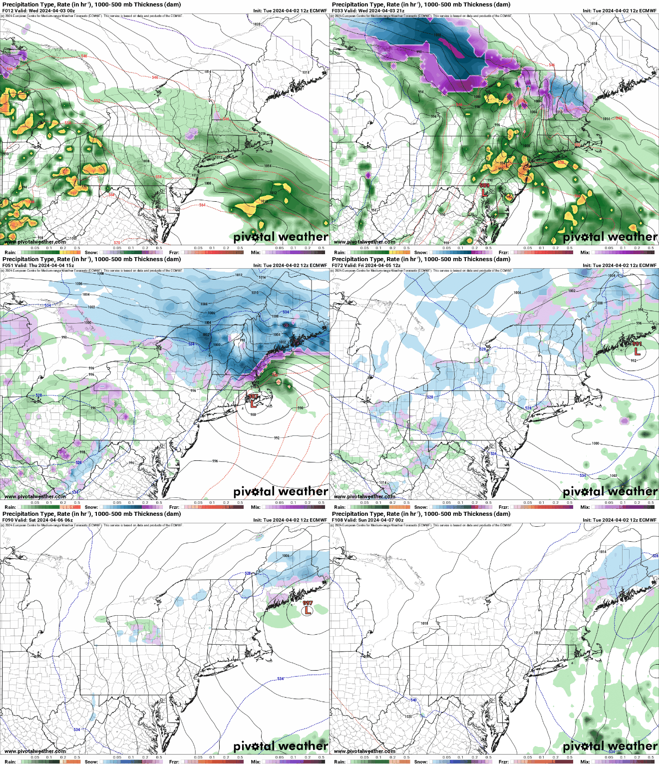
A long-duration late-season storm is headed our way, but despite the hype, it will not be a big “winter” storm for most of the region.

Low pressure is heading towards the Great Lakes this afternoon, producing severe weather across the Ohio and Tennessee Valleys. Rain was overspreading southwestern New England this afternoon and will continue do to so this evening, but aside from some brief bursts of steady rain, we’re just looking at some scattered showers through the evening, mainly south of the MA/NH border, with little precipitation expected overnight. Some snow may mix in across the hills of Worcester County, but little, if any, accumulation is expected. As we get into Wednesday, a secondary area of low pressure will develop over the Mid-Atlantic states and head northeastward. This will be the big weather-maker around here. Rain will redevelop, and temperatures will drop into the lower 40s and 30s, while east to northeast winds start to increase, resulting in a rather miserable early April day. Across the interior, especially in the hills of Worcester County and into the Monadnocks, the rain may be mixed with sleet. By evening, steadier and heavier precipitation will move in, with sleet changing to snow in the hills, and sleet and/or snow mixing in across areas north and west if I-495. By Thursday morning, the heaviest precipitation will move offshore, but showers will continue off and on, mixing with snow at times across the interior. As the system stalls out and an upper-level low moves in, the storm will meander around in the Gulf of Maine, keeping the shower activity going off and on into Friday and likely Saturday as well, before conditions improve on Sunday.

OK, that’s the general overview, here’s the details of what the impacts will be. First and foremost – heavy rain. Much of the region can expect 1-3 inches of liquid precipitation, which will be nearly all rain across the I-95 corridor and points south and east. Many rivers and streams are already running high, and this will only worsen the situation. The ground remains saturated, so there will be lots of people whose backyards become ponds, which could also result in flooded basements.

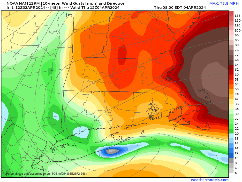
In addition to the rain, strong winds are likely. Sustained winds of 15-30 mph, with gusts of 40-50 mph or higher, especially along the coast, could result in some wind damage in spots. It will also produce some coastal flooding along east and northeast facing shorelines around the time of high tide on Wednesday and especially Wednesday night.

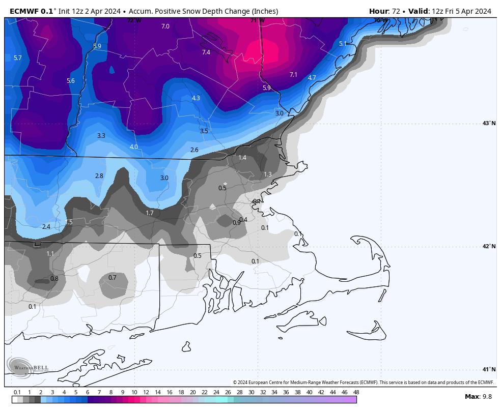
Now, to the “winter” part of this storm. By now, you’ve probably seen everyone sharing model snow maps showing unbelievable amounts of snow from this storm, especially across the interior. Don’t believe them, at all. They do not tell the story of what will happen. Allow us to explain. Under normal circumstances, 1 inch of liquid will result in 10 inches of snow, all other things being equal. That’s what these maps show, and you can usually see a reference to “10:1” on these maps. Things are not equal with this storm. For one, for most of the region, temperatures may not even get down to freezing, let alone below freezing. This changes the ratio closer to 5:1, instead of 10:1, so right off the bat, you need to cut the snow totals from those maps in half. Secondly, the sun angle is much higher now than in the middle of winter, roughly the equivalent of the sun angle around Labor Day. So, during the daytime, despite the cloudcover, the sun angle is high enough to prevent snow from accumulating unless it is coming down fairly hard. In this case, the heaviest precipitation is likely after dark. So, most of the snow that those maps show falling during the day, likely won’t accumulate. Third, many of the models show of layer of warmer air about 8000 feet above ground, especially during the late afternoon and evening. As snow falls into the warmer layer it will melt, then start to refreeze in a colder layer below it – that results in sleet. So, that cuts even more into those snow amounts. The farther north you go, as well as the higher up you go (in the hills), the better chance for some snow accumulation, but for the vast majority of people reading this post, you do not need to be concerned about snow. So, after all that, how much are we actually expecting?
Areas south and east of Interstate 495: Less than 1″
Northern MA/Southern NH (including the Seacoast): 1-3″
Areas north of Concord, NH and the hills of Worcester County/Monadnocks: 4-8″, with heavier amounts likely, especially the farther north you go.

The good news is that it is still looking like good weather for the eclipse on Monday. We’ll update you on that again in our Weekend Outlook on Thursday.