An active weather pattern means you won’t see the sun much this week.

High pressure is in control to start the week, but with plenty of low-level moisture around we’ll have plenty of clouds, along with some spotty drizzle. If we can get any sunshine, especially well inland, temperatures could get well into the 50s again, otherwise, places closer to the coast will stay in the 40s. A weak low pressure area moves up the coast for Tuesday, spreading some showers in, and keeping temperatures in the 40s, but that is still above normal for early March. We’ll turn much milder on Wednesday, with some spots possibly topping 60 degrees, despite plenty of clouds once again as another system begins to head toward the region. This one will bring in more rain for late Wednesday into Thursday, and some of it could be heavy. We’ll turn cooler on Thursday as system moves through, and there’s a chance that the rain could mix with snow before ending Thursday evening, especially north and west of Boston. Friday looks to be the pick of the week with some sunshine developing as high pressure builds in briefly.

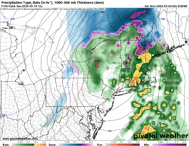
Next weekend is a bit uncertain at this point. Most of the models show a system impacting the region, but they don’t agree on the timing or the details of the system. Temperatures look to be colder, and there is a chance that we could see some snow from the system across parts of the region. It is still early March, so this is not an uncommon occurrence. We should have a better idea of what to expect and when to expect it by the time we get to our Weekend Outlook Thursday afternoon.
Also, don’t forget – Daylight Saving Time begins next Sunday at 2am, when we “Spring Ahead”, and you lose an hour of sleep. The good news? Sunset next Sunday is at 6:45pm.
Monday: Patchy morning fog, otherwise plenty of clouds with some spotty drizzle, a few sunny breaks possible, especially inland. High 47-54, coolest along the coast.
Monday night: Cloudy with a chance for a few late-night showers. Low 36-43.
Tuesday: Plenty of clouds with showers likely, especially in the afternoon. High 45-52.
Tuesday night: Overcast with showers ending in the evening. Low 38-45 during the evening, temperatures hold steady or rise a bit overnight.
Wednesday: Cloudy and milder with rain developing in the afternoon, possibly heavy at night. High 55-62, cooler across the South Coast and Cape Cod.
Thursday: Windy with showers gradually ending. High 42-49.
Friday: A mix of sun and clouds, breezy. High 42-49.
Saturday: Cloudy and breezy with some rain or snow possible. High 39-46.
Sunday: Cloudy and breezy with a chance for rain or snow. High 43-50.
