New year, new weather pattern? Well, sort of. We’ll still have above normal temperatures to start, but things could be changing significantly by next weekend.

We start the week (and year) off with some clouds thanks to a weak system passing offshore, but we’ll start to clear out this afternoon. High pressure builds in for tonight and Tuesday with seasonably cool and dry conditions. Wednesday remains dry as well, but we’ll see clouds start to filter in by late in the day. As we head into Thursday is when things start to change. Low pressure passes offshore while a cold front moves in from the north and west. Neither system will be particularly potent, but they will both bring in some rain or snow showers- the offshore system to coastal areas, especially southeastern Massachusetts, and the cold front produces some scattered rain or snow showers across the region. High pressure builds in behind these systems with cooler conditions for Friday. Another front tries to drop down from the north on Saturday, but stalls out nearby with just some cloudcover accompanying it. This brings us to Sunday, and you may want to sit down for this part (if you’re not sitting already).

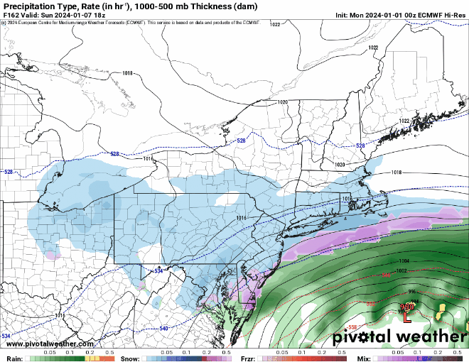
Low pressure moving out of the Tennessee Valley will redevelop near the Mid-Atlantic coastline, while high pressure builds into southeastern Canada. The developing low pressure system should pass south of New England while strengthening. Obviously, this is a week away, and we don’t want to get too detailed at this point, but things can and likely will change between now and then. but the potential exists for our first significant snowstorm of the winter on Sunday. There’s lots to iron out, such as where (if?) the rain/snow line will be? Will there be strong winds? How much of an impact will this storm have along the coast? Where will the heaviest snow fall (Or will there be any heavy snow?) There are too many questions, right now, and it’s just too early to answer them. However, consider this an early warning that there could be an impactful storm next Sunday. We’ll obviously have a much more detailed look at this potential storm in our Weekend Outlook on Thursday.
Monday: Morning clouds, then becoming partly to mostly sunny in the afternoon. High 33-40.
Monday night: Clear skies. Low 20-27.
Tuesday: Plenty of sunshine. High 33-40.
Tuesday night: Clear skies, some clouds start to move in late at night. Low 24-31.
Wednesday: Sunshine and a few clouds. High 37-44.
Thursday: Mostly cloudy, breezy, chance for a few rain or snow showers. High 36-43.
Friday: Mostly sunny, breezy, cooler. High 32-39.
Saturday: Morning sun, then increasing afternoon clouds. High 34-41.
Sunday: Cloudy and becoming windy with snow or rain possible. High 31-38.
