Uh oh. It’s that time. You might want to sit down. Yup. We’ve got some bad news for you. That word is in the forecast. You know which one we’re talking about. The one that you really don’t like. At all. It’s 4 letters, begins with “s” and ends with “w” and it rhymes with “no”. Yeah, that word. You knew it was coming eventually, but you still didn’t want to hear (or read) it. Well, it’s too late. You’ve been warned.
We start the week off with high pressure in control for Monday. The result is plenty of sunshine, but rather chilly temperatures, a stark contrast to what we had over the weekend. But, it is November, and the nice weather can’t last forever, because this is New England, not Miami or San Diego or St. Croix. Tuesday looks dry and chilly too, but we’ll have clouds streaming in ahead of a low pressure system moving toward the region.
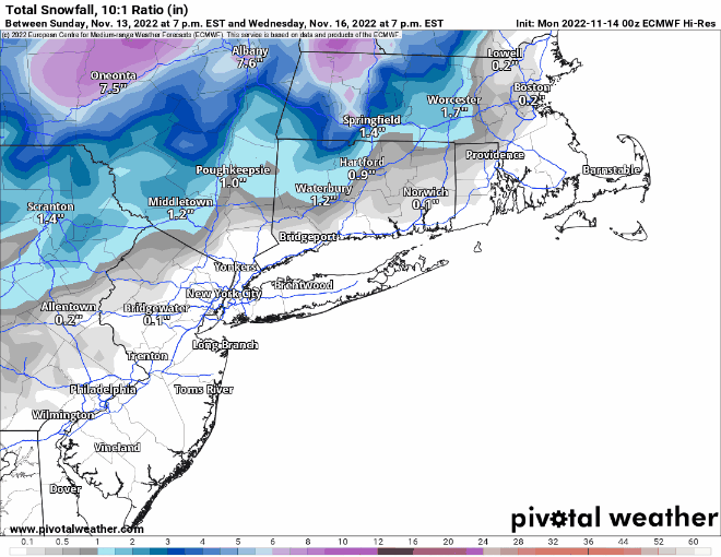
Tuesday night, some moisture will start streaming in ahead of that storm, and with temperatures likely near or below freezing, we may see some (WARNING: BAD WORD INCOMING) “snow” developing across the area. For areas from Boston southward, it may be just a few flurries or sprinkles Tuesday evening. The more substantial moisture moves in overnight, with most rain in the I-95 corridor and points south and east. North and west of there, especially outside of I-495, some wet snow may develop, but even here, it should change to rain by daybreak. The pavement remains far too warm for any accumulations (except for bridges and overpasses), but grassy surfaces, and car windshields could see some slushy accumulation, perhaps up to an inch as you head into southern New Hampshire. Across the Worcester Hills and up into the Monadnocks, there could even be a little more than that. Everything changes over to rain during the morning, and rain continues into the afternoon before winding down. There could be some gusty winds along the coast as well, but all in all, this is not a big deal. Across parts of Cape Cod and potentially southeastern Massachusetts, temperatures could briefly spike into the 50s or even 60s if the low tracks across the area, but for the rest of, Wednesday will feature temperatures in the 40s or even 30s.
An upper-level trough of low pressure crosses the Northeast of Thursday with some clouds and possibly a few sprinkles or flurries. High pressure then builds in for the end of the week and the weekend with generally dry and chilly conditions.

Monday: Plenty of sunshine, breezy at times. High 40-47.
Monday night: Mostly clear skies. Low 21-28.
Tuesday: Some morning sun, then clouds stream in. High 39-46.
Tuesday night: Cloudy with light rain developing at night, starting as light snow or a wintry mix north and west of Boston, gradually changing to all rain by daybreak. Up to an inch of slushy accumulation is possible on grassy surfaces north and west of I-495. Low 27-34, temperatures slowly rise after midnight.
Wednesday: Any lingering wintry mix changing to all rain, ending during the afternoon. High 40-47 north and west of Boston, 48-55 south, potentially warmer across Cape Cod.
Thursday: Partly sunny, breezy, chance for a rain or snow shower. High 40-47.
Friday: Partly to mostly sunny, breezy. High 39-46.
Saturday: Sunshine and a few clouds. High 37-44.
Sunday: Partly to mostly sunny. High 38-45.
