Quiet weather is expected for much of the upcoming weekend.
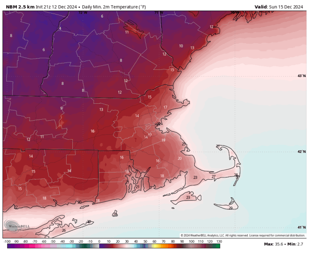
Sunday morning is looking rather chilly. Image provided by WeatherBell.
High pressure will build in and remain in control of our weather into Saturday, with dry and chilly conditions expected. As the high moves off to the east on Sunday, we’ll start to moderate, but also see clouds start to stream in ahead of a weak system. That system may bring in some rain showers on Monday, though it could start as some snow across the interior, mainly north and west of Interstate 495.
Some unsettled weather may move in on Monday, but it’s not definite at this point. Images provided by Pivotal Weather.
Thursday night: Clear to partly cloudy with diminishing winds. Low 19-26.
Friday: Sunshine and a few clouds. High 28-35.
Friday night: Clear skies, a few clouds across parts of Cape Cod. Low 15-22.
Saturday: Plenty of sunshine. High 29-36.
Saturday night: Clear to partly cloudy. Low 14-21, a little milder across Cape Cod.
Sunday: Increasing and thickening clouds. High 32-39.
Sunday night: Becoming mostly cloudy. Low 24-31.
Monday: Plenty of clouds with some showers possible, maybe starting as some snow outside of I-495. High 40-47.
The first half of the week is looking quite active, with all sorts of hazardous weather for the region.
Some much-needed rainfall is expected today and Wednesday, Image provided by WeatherBell.
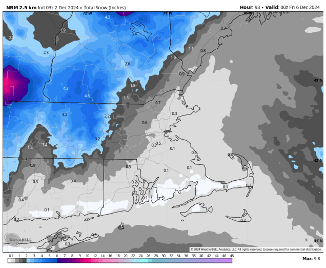
The week starts off with high pressure over Quebec keeping us dry, but that won’t last long. Low pressure heading into the Great Lakes sends some clouds our way, then a secondary low pressure system will develop, passing across southern New England tonight and early Tuesday. The result will be a period of rain for much of the region, starting late this afternoon, and ending shortly after midnight, but that’s not the entire story. Across southern New Hampshire, temperatures may be cold enough for the precipitation to start as snow, with some accumulation expected, mainly from Manchester northward. By evening, warmer air will move in aloft, but cold air may get trapped at the surface, so we could be looking some freezing rain, again, mostly from Manchester northward. Precipitation tapers off to drizzle or freezing drizzle after midnight as the system pulls away. Tuesday looks to be a cloudy day with some patchy drizzle at times, and temperatures holding steady or only very slowly rising as we head through much of the day.
Most of the snow we’re expecting tonight will be across southern and central New Hampshire. Image provided by Weathermodels.com
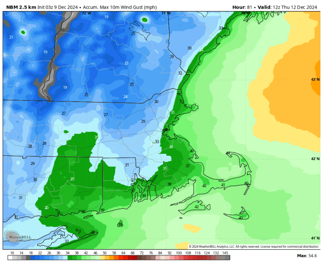
Another low pressure will start to make its way toward us Tuesday night into Wednesday, and this one will have some significant impacts on the region. We’ll see rain developing Tuesday night, continuing into Wednesday and it could be heavy at times. Many models are showing the potential for 1-2 inches of rain (or more), which would help put a dent in the ongoing drought. Accompanying the rain will be gusty south to southwest winds. Many models are showing the potential for wind gusts in excess of 40 mph across the region, with several showing even stronger winds, especially across eastern and southeastern Massachusetts. We’re skeptical that winds could be as strong as some of the models are showing, but it will be a windy day for sure. Those winds will also bring unseasonably warm air in, with temperatures likely getting well into the 50s across much of the region, with some places possibly topping 60. As the system passes by Wednesday night, it will drag a strong cold front through near or just after midnight. This will bring a quick end to the rainfall, but will also usher much colder air into the region. Many places could still be in the 50s or warmer at midnight, but will drop into the 30s by daybreak, and then hold steady or drop some more during the daytime hours despite clearing skies.
Gusty winds are likely on Tuesday, with the potential for wind gusts over 40 mph. Image provided by WeatherBell.
High pressure builds in for later Thursday into Saturday with mainly dry and cool conditions. Sunday is a bit of a question mark at this point. Some models show the potential for another system to move in with unsettled weather, some delay that storm until Monday, and some have it stay well to our south. At this point, it’s just too early to determine which, if any, solution is correct, so we’ll worry more about that in our Weekend Outlook on Thursday.
Sunday’s weather is a big question mark at this point. Images provided by Pivotal Weather.
Monday: Some morning sun, then becoming mostly cloudy with rain developing late in the day, except snow developing in southern New Hampshire. High 40-47.
Monday night: Cloudy, snow changing to freezing rain and potentially plain rain across southern New Hampshire, showers across the rest of the region, with everything winding down shortly after midnight, but a little drizzle or freezing drizzle may linger late at night. Low 28-35 north and west of I-95, 36-43 south and east of I-95.
Tuesday: Plenty of clouds with some spotty drizzle, maybe some freezing drizzle across southern New Hampshire. High 33-40 north of the Mass Pike 41-48 south of the Pike, a little warmer across Cape Cod and the South Coast.
Tuesday night: Cloudy with showers developing, possibly starting as a little freezing rain across central New Hampshire. Low 32-39 during the evening north and west of I-95, 40-47 south and east of I-95, temperatures slowly rise overnight.
Wednesday: Cloudy with periods of rain, some of it could be heavy, becoming windy. Rain ends shortly after midnight. High 56-63.
Thursday: Becoming partly sunny, breezy, especially in the morning. High 36-43 early, temperatures hold steady or drop during the day.
Friday: Sunshine and some afternoon clouds. High 30-37.
Saturday: Mostly sunny in the morning, clouds start to move in during the afternoon. High 34-41.
Sunday: Partly to mostly cloudy with a chance of rain, especially late in the day. High 38-45.
We’ve got a couple of chilly days coming up, but a warmup is in store for the end of the weekend.
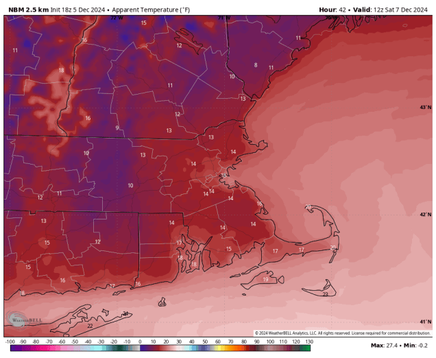
Wind chills will be in the teens Saturday morning. Image provided by WeatherBell.
The storm system that brought us snow earlier today continues to pull away and a cold front moves through this evening with a few snow showers or squalls, setting the stage for a couple of chilly days across the region. Gusty west to northwest winds usher much cooler air in for tonight and Friday as skies clear out with high pressure building in. Many places may not reach freezing on Friday, and wind chills will be in the teens in spots. Saturday looks fairly chilly as well, but we’ll see some clouds stream in ahead of another fast-moving storm system. That system passes north of the region Saturday night and early Sunday, with a few snow showers possible, mainly north of the Mass Pike. We’ll start to turn milder on Sunday as winds become southwesterly. Monday will see more clouds move in ahead of another storm system, which brings in some showers during the afternoon, but south to southwest winds will send temperatures back up well into the 40s.
Some places could make a run at 50 on Monday. Image provided by Weathernodels.com
Thursday night: Any lingering snow showers end in the evening, becoming clear to partly cloudy, breezy. Low 21-28.
Friday: Sunshine and some afternoon clouds, breezy. High 28-35.
Friday night: Clear to partly cloudy. Low 17-24.
Saturday: Sunny in the morning, then clouds move in during the afternoon. High 31-38.
Saturday night: Becoming mostly cloudy, chance for some late-night snow showers, mainly north of the Mass Pike. Low 20-27.
Sunday: Morning clouds and a few snow showers north of the Mass Pike, some clearing late in the day. High 38-45.
Sunday night: Partly cloudy. Low 27-34.
Monday: Becoming mostly cloudy, showers develop in the afternoon. High 43-50.
The coldest air so far this season will move in this week and there’s a chance for some snow as well.
We’re looking at wind chills in the teens later this week. Image provided by Weathermodels.com
We start the week off with high pressure in control, keeping us dry and cool for the most part. The exception will be across parts of Cape Cod and the Islands, where colder air flowing over the still relatively mild Atlantic may result in some ocean effect rain or snow showers during the next few days. Clouds start to move in on Wednesday ahead of a storm system moving across Southern Canada. This system have just enough moisture accompanying it to produce some snow or rain showers across the region Wednesday night into part of Thursday. Any accumulating snow will likely be confined to the interior, and even there we’re only talking about the potential for a couple of inches, mainly across the hills. Behind that system, some of the coldest air so far this season settles in for Friday into Saturday. Another weak system may produce some snow showers Saturday night into part of Sunday.
Most of the accumulating snow Wednesday night and Thursday will be across the interior. Image provided by WeatherBell.
Monday: Partly to mostly sunny, chance for a rain or snow shower across the Outer Cape and Islands. High 33-40.
Monday night: Clear skies, except partly cloudy with a chance for a rain or snow shower across the Outer Cape and Islands. Low 19-26, a little milder across the Outer Cape and Islands.
Tuesday: Sunshine and some afternoon clouds, again a chance for a rain or snow shower across the Outer Cape and Islands. High 33-40.
Tuesday night: Clear to partly cloudy. Low 17-24, a little milder across the Outer Cape and Islands.
Wednesday: Increasing clouds, snow or rain showers likely at night. High 37-44.
Thursday: Snow or rain showers end, some late-day clearing, breezy. High 39-46.
Friday: Mostly sunny, breezy, and chilly. High 29-36.
Saturday: Morning sun, then increasing clouds, chance for some snow showers at night. High 29-36.
Sunday: Chance for some morning snow showers, becoming partly sunny. High 35-42.
Turkey Day is looking wet, but after that things will turn colder around here.
Below normal temperatures are expected through the holiday weekend. Image provided by Weathermodels.com.
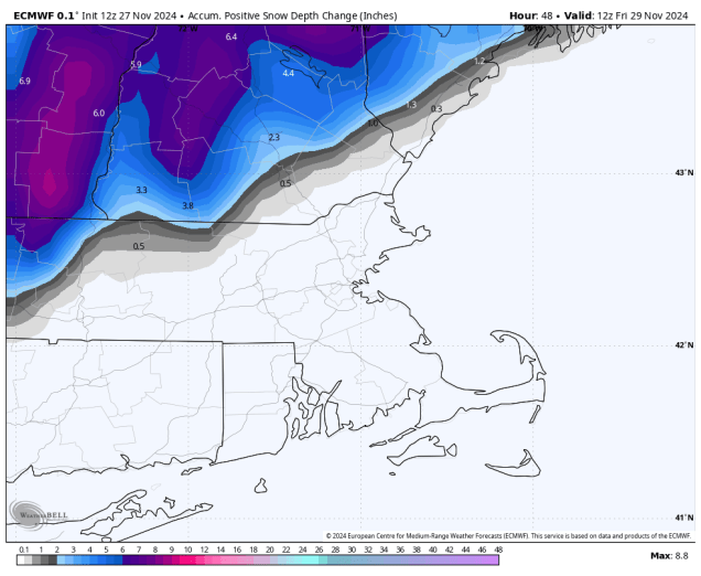
Low pressure will move out of the Tennessee Valley tonight and head towards Southern New England, passing near or just south of the South Coast on Thanksgiving Day. For most of us, we’ll see rain developing around daybreak, and ending in the evening, but across the hills from Worcester County into the Monadnocks of southwestern New Hampshire, some snow is likely, with a few inches possible. Across the rest of southern New Hampshire, we may see the rain start as snow in the morning, but it should quickly change to rain, with little to no accumulation. Farther north, especially north of Concord, NH, a few inches may accumulate, before a change to rain occurs. The system starts to pull away Thursday evening, with the rain ending before midnight, though we could see some flakes mix in as the rain winds down.
Any accumulating snow should stay well north and west of Boston on Thursday. Image provided by WeatherBell.
As the storm moves into Atlantic Canada, we’ll clear out for Friday with breezy and colder conditions. A few stray rain or snow showers are possible, especially across Cape Cod where the winds blowing over the still relatively mild water may generate some ocean-effect showers. Another weak disturbance moves through Friday night with just a few flurries, then even colder air settles in for the weekend and Monday. With an upper-level low over the Northeast and disturbances rotating around it, we could see a few widely scattered flurries or snow showers each day.
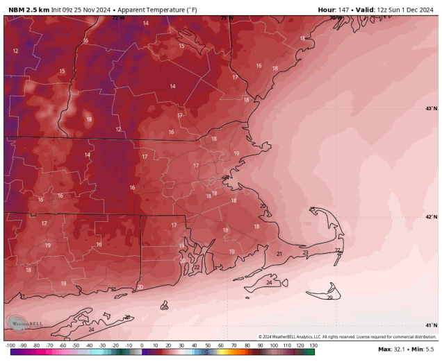
Wind chills will be in the teens Sunday morning. Image provided by Weathermodels.com
Wednesday night: Becoming cloudy, rain may develop towards daybreak, mixed with snow well north and west of Boston. Low 29-36, temperatures may start to rise after midnight.
Thursday: Periods of rain, mixed with snow in the morning, especially from the hills of Worcester County into southern New Hampshire, becoming breezy along the coast. High 39-46 north and west of I-95 47-54 south and east of I-95.
Thursday night: Rain ending before midnight, possibly mixed with some wet snow, some clearing late at night, breezy along the coast during the evening. Low 30-37.
Friday: Partly to mostly sunny. High 40-47.
Friday night: Clear to partly cloudy, chance for a few rain or snow showers across Cape Cod. Low 25-32.
Saturday: Sunshine and some afternoon clouds, slight chance for a few flurries, especially across the Outer Cape, breezy, colder. High 37-44.
Saturday night: Partly cloudy. Low 22-29.
Sunday: A mix of sun and clouds, chance for a few flurries, breezy, chilly. High 35-42.
We’ll get right to the point – despite the hype over the past several days, the vast majority of the region will NOT be having a White Thanksgiving. However, we are expecting more much-needed rainfall this week.
Another 1/4-1/2 inch of much-needed rain is expected on Tuesday. Image provided by Weathermodels.com
We start the week off with high pressure in control, providing us with sunshine and seasonably cool temperatures. Clouds start to move in tonight as low pressure moves from the Great Lakes towards Northern New England. This system will bring us some rain Tuesday morning and afternoon, but we’re a little concerned about Tuesday morning in particular. Temperatures will cool off pretty quickly Monday evening before the clouds arrive, and by the time the rain moves in near or just after daybreak, temperatures may be near freezing across parts of southern New Hampshire. The ground remains fairly warm, but if it’s near 32 and starts to rain, there could be a little icing, especially on elevated surfaces like bridges and overpasses. Temperatures should quickly rise above 32 after daybreak, but if you’re going to be out in southern New Hampshire around daybreak Tuesday, use a little extra caution, especially if the rain moves in a little earlier than currently expected. Rain ends Tuesday afternoon and we clear out at night as high pressure builds in Tuesday night. Wednesday starts off with sunshine, but clouds stream right back in during the afternoon as low pressure begins to move out of the Tennessee Valley.
The models agree the Thanksgiving will be stormy, but don’t agree on the details. Images provided by Pivotal Weather.
The latest indications are that this low pressure system will pass south of New England or possibly across Cape Cod during Thanksgiving and into Friday morning. The result will likely be a rainy Turkey Day, so keep this in mind if you are traveling for the holiday. Of course, this is far from locked in, as there is still some uncertainty in the models. Some show the storm passing far enough south that it misses the region entirely. Some bring in a period of heavier rain, and some have enough cold air in place at the start that the rain may start as snow across the interior on Thanksgiving Day, before quickly changing to rain. None of the models show a major snowstorm around here any more, despite a couple of runs of the models doing so last week. One or two show some decent accumulations for ski country, but even that is far from certain at this point. We’ll have much more detail in our Weekend Outlook which will be published on Wednesday this week with the holiday on Thursday. The storm pulls away Friday morning, and there’s the possibility that the rain could change over to snow before ending across areas north and west of Boston, but again, this is far from certain at this point. Blustery and colder weather moves in behind that storm for the weekend, with a few flurries possible at times.
Bundle up if you’ll be out early Sunday morning, with wind chills in the teens. Image provided by WeatherBell.
Monday: Mostly sunny, clouds start to filter in towards evening, breezy. High 44-51.
Monday night: Becoming mostly cloudy, showers developing late at night, possibly as some freezing rain across southern New Hampshire. Low 30-37.
Tuesday: Rain likely, ending during the afternoon, some clearing late in the day. High 42-49 north of the Mass Pike, 50-57 south of the Pike.
Tuesday night: Becoming clear. Low 31-38.
Wednesday: Breezy with sunshine during the morning, then clouds start to move back in during the afternoon. High 43-50.
Thanksgiving Day: Cloudy with rain developing, possibly starting as a little wet snow across the interior. High 42-49 north and west of I-95, 50-57 south and east of I-95.
Friday: Showers ending in the morning, possibly changing to snow before ending across the interior, some clearing may develop in the afternoon. High 41-48.
Saturday: Partly sunny, breezy, colder, chance for a few flurries. High 37-44.
Sunday: A mix of sun and clouds, breezy, chilly, chance for a few flurries. High 35-42.
Much-needed rain has finally made its way to the region, and more is coming.
Much of the region could pick up an inch or more of rain by the end of the weekend. Image provided by Weathermodels.com
After weeks without significant rainfall, we finally had some move in today as low pressure moved south of New England. An upper-level low pressure system will move out of the Great Lakes and into the Northeast, pulling that system into New York and Pennsylvania tonight, which means the steady rain this evening will taper off to showers overnight. The upper low then moves in for Friday, and while there could be some sunny breaks in the morning, for the most part we’ll have plenty of clouds with a few showers around. With some cold air aloft, there could be a few snowflakes mixed in, especially across the higher terrain of central Massachusetts and southwestern New Hampshire. A disturbance rotating around that upper-level low will trigger a new storm system south and east of New England, bringing rain and gusty winds back in for late Friday into early Saturday, mainly across eastern Massachusetts and Rhode Island. If the precipitation shield can extend far enough west, the rain may change to snow across the hills of Worcester County and the Monadnocks of southern New Hampshire. That low pulls away on Saturday, but we’ll be slow to clear out, with a gusty northwest breeze keeping us on the cool side. High pressure builds in for Sunday with more sunshine, but there will still be some clouds around with the upper-level low nearby. Monday starts off with some sun, but then clouds start to move back in during the afternoon as another storm system heads this way from the Great Lakes. This will likely bring in more rain showers for Monday night and Tuesday.
Wind gusts of 30-40 mph are possible this weekend. Image provided by WeatherBell.
Thursday night: Rain tapers off to showers, ending overnight, some partial clearing possible late at night, breezy. Low 38-45.
Friday: Some sunshine in the morning, then clouds return with a few showers around, becoming a steadier rain late in the day across eastern Massachusetts and Rhode Island, possibly mixed with some wet snow across the higher terrain from central Massachusetts into southern New Hampshire. High 46-53.
Friday night: Periods of rain, mainly across eastern Massachusetts and southern New Hampshire, possibly mixed with some wet snow across the higher terrain from central Massachusetts into southern New Hampshire. Low 34-41.
Saturday: Cloudy and breezy with showers (or wet snow) ending in the morning, though there could be a few more showers around in the afternoon. High 43-50.
Saturday night: Partly to mostly cloudy, breezy. Low 35-42.
Sunday: A mix of sun and clouds, windy. High 44-51.
Sunday night: Clear to partly cloudy. Low 30-37.
Monday: Morning sun, clouds start to move back in during the afternoon. High 47-54.
Finally, since the hype train already left the station yesterday, we’ll address the possibility of a “White Thanksgiving”. Yes, a couple of models have occasionally shown the potential for a storm system next weekend. However, these models have been highly inconsistent at that range, and they vary widely on the track, strength, and timing of the potential system, and what, if any, impact it might have here. Anything from wind-swept rain to heavy snow, to a sunny but cool weekend is on tap. It’s just WAY too early to even speculate on what might happen a week from now. We’ll address it a little more in our Weekly Outlook early Monday, but even then, the details will probably still be a fuzzy. Bottom line: don’t worry about it, don’t go cancelling any Thanksgiving weekend plans, and stay tuned for further updates. If there is anything to worry about, we’ll let you know well in advance.
The models all have very different solutions for Thanksgiving Day. Images provided by Pivotal Weather,
It looks like we may finally get some rain this week.
Rainfall totals over the past 6 months are only 1/2 to 3/4 of normal across the region. Image provided by WeatherBell.
We start the week off with some clouds this morning as a weak system moves through, but as has been the case for a while now, it will be accompanied by little, if any, rainfall. We’ll clear out this afternoon with breezy conditions, increasing the fire danger once again. Tuesday and Wednesday look dry and mild with high pressure in control once again, so we’ll remain in a high fire danger situation. Things begin to change for the second half of the week though.
Another very mild day is expected across the region today. Image provided by Weathermodels.com
A low pressure system that will bring a significant storm system to the nation’s mid-section to start the week will head into central Canada while an upper-level low pressure system moves from the Plains into the Great Lakes, and by the end of the week into the Northeast. A disturbance rotating around that upper-low will trigger a new low pressure system at the surface by mid-week in the Ohio Valley, which should bring in some much-needed rain around here for Thursday. There is still a lot of uncertainty with this storm, as it may draw in some of the remnants of Sara, adding some additional juice to the system. However, the track the storm takes will determine if we just get some occasional showers and a brief period of steady rain, or some prolonged heavier rain. Recent history would suggest the former, but the latter can’t be ruled out yet. We’ll update you on this during the week if needed. By the end of the week, that upper-level low moves in, with some occasional showers and much cooler weather for Friday and likely Saturday as well. In fact, those showers may fall as snow showers across the higher terrain from Worcester County into the Monadnocks of southern New Hampshire, and we could see some snowflakes mixed in at the lower elevations as well. High pressure then builds back in for Sunday with drier and cool conditions.
The models all have different ideas on where the storm system will be on Thursday and how much rain it will bring in. Images provided by Pivotal Weather.
Monday: Morning clouds and a slight chance for a sprinkle, then becoming partly to mostly sunny, a little breezy in the afternoon, quite mild. High 55-62.
Monday night: Clear to partly cloudy. Low 36-43.
Tuesday: Sunshine and a few clouds, breezy. High 51-58.
Tuesday night: Clear to partly cloudy. Low 32-39.
Wednesday: Mostly sunny, clouds start to filter in during the afternoon. High 50-57.
Thursday: Cloudy and breezy with showers developing, possibly some steadier rain. High 47-54.
Friday: Mostly cloudy with more showers around, possibly mixed with some wet snow, especially across the higher terrain. High 44-51.
Saturday: More clouds than sunshine, breezy, chance for a few more showers. High 44-51.
After a few chilly days, a warmup is in store for the weekend.
Temperatures will be above normal again this weekend. Image provided by Weathermodels.com
High pressure will keep us dry for the next few days, but that doesn’t mean it’s a simple forecast. A weak system passing well to our south and west tonight will spread some high clouds in, which will be just enough to keep us from getting as cold as last night. As that system pulls away on Friday, a bigger storm moving into Atlantic Canada will start to drift westward, sending more clouds our way during the afternoon, and these will be a little thicker, especially along the coast. However, we’ll also start to warm up as the airmass begins to moderate. The clouds start to move out on Saturday as upper-level high pressure builds in, with developing sunshine and milder temperatures. On Sunday, we flip things around with sunshine in the morning, then clouds start to move back in during the afternoon as a weak disturbance approaches from the west. It may produce a few widely scattered showers as it moves through on Monday, but this is far from the drought-buster that we desperately need.
The drought continues to worsen across the region. Image provided by the National Drought Mitigation Center.
Thursday night: Partly cloudy. Low 24-31, a little milder across Cape Cod.
Friday: Becoming sunny in the morning, clouds start to move back in by late in the day. High 49-56.
Friday night: Partly cloudy. Low 35-42.
Saturday: Morning clouds, especially near the coast, then becoming sunny again, breezy. High 54-61.
Saturday night: Clear skies. Low 36-43.
Sunday: Sunny through the morning, clouds start to move back in during the afternoon. High 54-61.
Sunday night: Becoming mostly cloudy. Low 36-43.
Monday: Morning clouds, possibly a shower, some afternoon clearing. High 56-63.
Although today will be mild, much of this week will be cooler than we have been for a while.
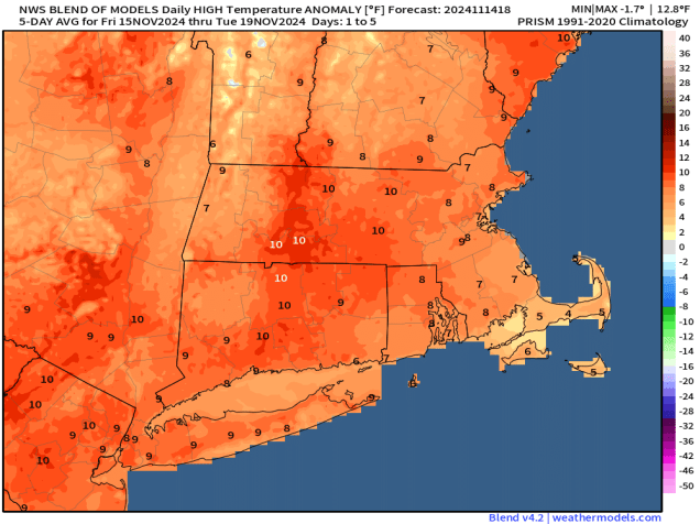
Today will be the warmest day of the week by a large margin. Image provided by WeatherBell.
A warm front moved through overnight, setting us up for a mild day today, with some spots possibly making a run at 70 degrees. Any lingering showers will end this morning as a cold front moves through, with rapid clearing behind the front this afternoon. However, the airmass behind the front isn’t that cold, which is one reason why we’ll be some warm today. A second cold front moves through late tonight or early Tuesday with little moisture accompanying it. Behind it, gusty northwest winds will usher some cooler air in during the day. As high pressure moves right overhead on Wednesday we’ll have sunshine but temperatures will be quite cool, even below normal for mid-November. That high pressure area will settle into eastern Canada for the end of the week, keeping us dry and cool. A weak low pressure system moving out of the Great Lakes will spread some clouds in on Thursday, but it looks like that system will slide off to our south, so we’re not expecting any rainfall from it.
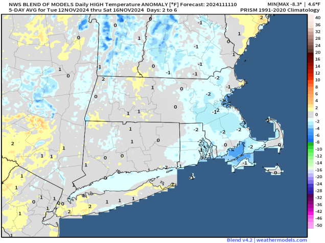
Temperatures will be a little below normal for much of this week. Image provided by Weathermodels.com.
The end of the week and the weekend becomes a little more complicated, but the end result is that we should remain dry and seasonably cool. We’ll have an ocean storm moving into Atlantic Canada that is going to try and back in from the east, and a big high pressure centered to our west. The high should win out, keeping us dry and seasonably cool, but there may be clouds and a few showers at times, and possibly some gusty winds, especially near the coast, thanks to the ocean storm. We’ll keep a close eye on how this actually evolves later this week, and will update things in our Weekend Outlook on Thursday.
The weekend forecast is a battle between low pressure to our east and high pressure to our west. Images provided by Pivotal Weather.
Monday: Showers ending early, then skies become mostly sunny in the afternoon, breezy. High 61-68.
Monday night: Clear to partly cloudy, becoming breezy again late at night. Low 40-47.
Tuesday: Sunshine and a few clouds, breezy, cooler. High 48-55.
Tuesday night: Partly cloudy across Cape Cod and the Islands, clear elsewhere. Low 25-32, a little milder across Cape Cod and the Islands.
Wednesday: Plenty of sunshine with a few clouds across Cape Cod and the Islands, chilly. High 41-48.
Thursday: Intervals of clouds and sun. High 41-48.
Friday: Partly sunny, clouds may become a little more prevalent late in the day with just a slight chance for a few showers, especially near the coast. High 46-53.
Saturday: A mix of sun and clouds, breezy. High 49-56.